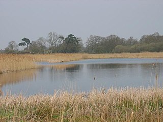
Redgrave and Lopham Fens is a 127 hectare biological Site of Special Scientific Interest between Thelnetham in Suffolk and Diss in Norfolk. It is a national nature reserve, a Ramsar internationally important wetland site, a Nature Conservation Review site, Grade I, and part of the Waveney and Little Ouse Valley Fens Special Area of Conservation. It is managed by the Suffolk Wildlife Trust.

A marsh is - according to ecological definitions - a wetland that is dominated by herbaceous rather than woody plant species. More in general, the word can be used for any low-lying and seasonally waterlogged terrain. In Europe and in agricultural literature low-lying meadows that require draining and embanked polderlands are also referred to as marshes or marshland.

Reed is a common name for several tall, grass-like plants of wetlands.

Phragmites is a genus of four species of large perennial reed grasses found in wetlands throughout temperate and tropical regions of the world.

Phalaris arundinacea, or reed canary grass, is a tall, perennial bunchgrass that commonly forms extensive single-species stands along the margins of lakes and streams and in wet open areas, with a wide distribution in Europe, Asia, northern Africa and North America. Other common names for the plant include gardener's-garters and ribbon grass in English, alpiste roseau in French, Rohrglanzgras in German, kusa-yoshi in Japanese, caniço-malhado in Portuguese, and hierba cinta and pasto cinto in Spanish.

Lake Neusiedl, or Fertő, is the largest endorheic lake in Central Europe, straddling the Austrian–Hungarian border. The lake covers 315 km2 (122 sq mi), of which 240 km2 (93 sq mi) is on the Austrian side and 75 km2 (29 sq mi) on the Hungarian side. The lake's drainage basin has an area of about 1,120 km2 (430 sq mi). From north to south, the lake is about 36 km (22 mi) long, and it is between 6 km and 12 km wide from east to west. On average, the lake's surface is 115.45 m (378.8 ft) above the Adriatic Sea and the lake is no more than 1.8 m deep.

The Manawatū River is a major river of the lower North Island of New Zealand. The river flows from the Ruahine Ranges, through both the Manawatū Gorge and the city of Palmerston North, and across the Manawatū Plains to the Tasman Sea at Foxton.

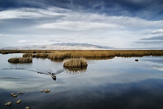
The Uru or Uros are an indigenous people of Bolivia. They live on a still growing group of about 120 self-fashioned floating islands in Lake Titicaca near Puno. They form three main groups: the Uru-Chipaya, Uru-Murato, and Uru-Iruito. The Uru-Iruito still inhabit the Bolivian side of Lake Titicaca and the Desaguadero River.

A reedbed or reed bed is a natural habitat found in floodplains, waterlogged depressions and estuaries. Reedbeds are part of a succession from young reeds colonising open water or wet ground through a gradation of increasingly dry ground. As reedbeds age, they build up a considerable litter layer that eventually rises above the water level and that ultimately provides opportunities in the form of new areas for larger terrestrial plants such as shrubs and trees to colonise.

A marine transgression is a geologic event during which sea level rises relative to the land and the shoreline moves toward higher ground, which results in flooding. Transgressions can be caused by the land sinking or by the ocean basins filling with water or decreasing in capacity. Transgressions and regressions may be caused by tectonic events such as orogenies, severe climate change such as ice ages or isostatic adjustments following removal of ice or sediment load.

The Lang Lang River is a perennial river of the Western Port catchment, located in the West Gippsland region of the Australian state of Victoria.

Fowlmere is a Royal Society for the Protection of Birds nature reserve between Fowlmere and Melbourn in Cambridgeshire. It is designated a 39.9-hectare (99-acre) biological Site of Special Scientific Interest called Fowlmere Watercress Beds.

A hydrosere is a plant succession which occurs in an area of fresh water such as in oxbow lakes and kettle lakes. In time, an area of open freshwater will naturally dry out, ultimately becoming woodland. During this change, a range of different landtypes such as swamp and marsh will succeed each other.

Camley Street Natural Park is an urban nature reserve in St Pancras in central London and within the London Borough of Camden. It is a local nature reserve.

The southwestern water vole or southern water vole is a large amphibious vole native to most of France and southwestwards through Spain and Portugal. It is listed on the IUCN Red List as vulnerable. Although historically considered to be a member of the same species as the European water vole, Musser and Carleton (2005) considered it distinct enough to warrant full species status. It is threatened for many of the same reasons as the European water vole, and a campaign is currently underway to seek protection for the species, both at a national level and at European Union level.

Ingrebourne Marshes are a 74.8 hectare biological Site of Special Scientific Interest in Hornchurch in the London Borough of Havering. Ingrebourne Valley Local Nature Reserve includes a small part of the SSSI west of the River Ingrebourne. The site is managed by the Essex Wildlife Trust

Ham Wall is an English wetland National Nature Reserve (NNR) 4 kilometres (2.5 mi) west of Glastonbury on the Somerset Levels. It is managed by the Royal Society for the Protection of Birds (RSPB). Since the last Ice Age, decomposing plants in the marshes of the Brue valley in Somerset have accumulated as deep layers of peat that were commercially exploited on a large scale in the twentieth century. Consumer demand eventually declined, and in 1994 the landowners, Fisons, gave their old workings to what is now Natural England, who passed the management of the 260 hectares Ham Wall section to the RSPB.
Lake Eber is a freshwater lake in Afyon Province, Turkey. The lake used to be connected with nearby Lake Akşehir and was named Tessarakonta Martyron, the Forty Martyr's lake, in premodern times.

The Obersee is the smaller of the two parts of Zürichsee in the cantons of St. Gallen and Schwyz in Switzerland.

Woodberry Wetlands is a nature reserve and designated Site of Metropolitan Importance on the site of the East Reservoir in the Manor House area in the London Borough of Hackney. The site opened to the public for the first time in 200 years on 1 May 2016. Covering 4.5 ha and situated close to the Lee Valley, Woodberry Wetlands was acquired as a nature reserve in 2014. The site is owned by Thames Water and run by London Wildlife Trust.
