
The Grave Creek Mound in the Ohio River Valley in West Virginia is one of the largest conical-type burial mounds in the United States, now standing 62 feet (19 m) high and 240 feet (73 m) in diameter. The builders of the site, members of the Adena culture, moved more than 60,000 tons of dirt to create it about 250–150 BC.

The Dravo Gravel Site (33HA377) is an archaeological site located above the Great Miami River in Miami Township, Hamilton County, Ohio, United States. Discovered in the middle of a gravel pit, the site is a leading example of the local manifestation of the Archaic period.

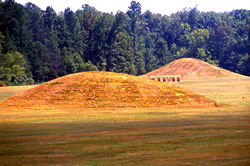
Town Creek Indian Mound is a prehistoric Native American archaeological site located near present-day Mount Gilead, Montgomery County, North Carolina, in the United States. The site, whose main features are a platform mound with a surrounding village and wooden defensive palisade, was built by the Pee Dee, a South Appalachian Mississippian culture people that developed in the region as early as 980 CE. They thrived in the Pee Dee River region of North and South Carolina during the Pre-Columbian era. The Town Creek site was an important ceremonial site occupied from about 1150—1400 CE. It was abandoned for unknown reasons. It is the only ceremonial mound and village center of the Pee Dee located within North Carolina.

The Nodena site is an archeological site east of Wilson, Arkansas, and northeast of Reverie, Tennessee, in Mississippi County, Arkansas, United States. Around 1400–1650 CE an aboriginal palisaded village existed in the Nodena area on a meander bend of the Mississippi River. The Nodena site was discovered and first documented by Dr. James K. Hampson, archaeologist and owner of the plantation on which the Nodena site is located. Artifacts from this site are on display in the Hampson Museum State Park in Wilson, Arkansas. The Nodena site is the type site for the Nodena phase, believed by many archaeologists to be the province of Pacaha visited by Spanish explorer Hernando de Soto in 1542.

The Eaker site (3MS105) is an archaeological site on Eaker Air Force Base near Blytheville, Arkansas, that was declared a National Historic Landmark in 1996. The site is the largest and most intact Late Mississippian Nodena phase village site within the Central Mississippi Valley, with archaeological evidence indicating a palisaded village some 50 acres (20 ha) in size, with hundreds of structures. The site's major period of occupation was 1350–1450 CE, although evidence of occupation dates back to 600 CE. The site is also hypothesized to have been occupied by the Quapaw prior to a migration further south, after which they made contact with Europeans in the late 17th century.

The Kincaid Mounds Historic Site c. 1050–1400 CE, is a Mississippian culture archaeological site located at the southern tip of present-day U.S. state of Illinois, along the Ohio River. Kincaid Mounds has been notable for both its significant role in native North American prehistory and for the central role the site has played in the development of modern archaeological techniques. The site had at least 11 substructure platform mounds, and 8 other monuments.

The Boyd Mounds Site (22MD512) is an archaeological site from the Late Woodland and Early Mississippian period located in Madison County, Mississippi near Ridgeland. Many of the mounds were excavated by The National Park Service in 1964. It is located at mile 106.9 on the old Natchez Trace, now the Natchez Trace Parkway. It was added to the NRHP on July 14, 1989 as NRIS number 89000784.

Old Town is an archaeological site in Williamson County, Tennessee near Franklin. The site includes the remnants of a Native American village and mound complex of the Mississippian culture, and is listed on the National Register of Historic Places (NRHP) as Old Town Archaeological Site (40WM2).
Pharr Mounds is a Middle Woodland period archaeological site located near Tupelo in parts of Itawamba and Prentiss counties in northern Mississippi. This complex was made of earthwork mounds.
The Beasley Mounds Site (40SM43) is a Mississippian culture archaeological site located at the confluence of Dixon Creek and the Cumberland River near the unincorporated community of Dixon Springs in Smith County, Tennessee. The site was first excavated by amateur archaeologists in the 1890s. More examples of Mississippian stone statuary have been found at the site than any other in the Middle Tennessee area. The site was listed on the National Register of Historic Places in 2010.
Potomac Creek, or 44ST2, is a late Native American village located on the Potomac River in Stafford County, Virginia. It is from the Woodland Period and dates from 1300 to 1550. There is another Potomac Creek site, 44ST1 or Indian Point, which was occupied by the Patawomeck during the historic period and is where Captain John Smith visited. This site no longer exists, as it eroded away into the river. Site 44ST2 has five ossuaries, one individual burial, and one multiple burial. Other names for the site are Potowemeke and Patawomeke. The defining features include distinctive ceramics, ossuary burials, and palisade villages.

The Younge site is an archeological site located in Goodland Township, Lapeer County, Michigan. It is classified as a prehistoric Late Woodland site and was designated as a Michigan State Historic Site on October 29, 1971. It was added to the National Register of Historic Places on October 29, 1976.

The Juntunen site, also known as 20MK1, is a stratified prehistoric Late Woodland fishing village located on the western tip of Bois Blanc Island. It was listed on the National Register of Historic Places in 1978.

The Otter Creek Archaeological Site is a prehistoric Native American site in rural Franklin County, Virginia. Located in the uplands of the Blue Ridge Mountains near Ferrum, the site encompasses a settlement that has been dated to the Late Woodland Period. Finds at the site included fired lumps of clay, suggestive of the idea that clay pipes and other artifacts were made here.

The Martin Site (44WY13) is a prehistoric Native American village site in Wythe County, Virginia, United States. It is located on the banks of the New River near the community of Fosters Falls. The site has clear evidence of occupation during the Late Woodland period, and offers evidence of older occupation. Finds at the site include pottery sherds, stone tools, ceramic and shell trade items, and grave sites.

The Moccasin Bluff site is an archaeological site located along the Red Bud Trail and the St. Joseph River north of Buchanan, Michigan. It was listed on the National Register of Historic Places in 1977, and has been classified as a multi-component prehistoric site with the major component dating to the Late Woodland/Upper Mississippian period.
The Annis Mound and Village site is a prehistoric Middle Mississippian culture archaeological site located on the bank of the Green River in Butler County, Kentucky, several miles northwest of Morgantown in the Big Bend region. It was occupied from about 800 CE to about 1300 CE.
Whittlesey culture is an archaeological designation for a Native American people, who lived in northeastern Ohio during the Late Precontact and Early Contact period between A.D. 1000 to 1640. By 1500, they flourished as an agrarian society that grew maize, beans, and squash. After European contact, their population decreased due to disease, malnutrition, and warfare. There was a period of long, cold winters that would have impacted their success cultivating food from about 1500.
The Mouse Creek phase is an archaeological culture of the Eastern Tennessee region of Mississippian chiefdoms, first defined by T. M. N. Lewis and Madeline Kneberg in their examinations of the Chickamauga Basin. This area exhibits artifacts, burials, and architecture distinct from other settlements in the area. The region was occupied from around 1400–1600.


