Richmondtown is a neighborhood in the Mid-Island section of Staten Island, New York City. It is bounded by Arthur Kill Road on the northwest, Richmond Road on the north, Amboy Road on the east and southeast, and the United Hebrew and Ocean View cemeteries on the southwest.

Port Richmond is a neighborhood situated on the North Shore of Staten Island, a borough of New York City. Port Richmond is bounded by Kill van Kull on the north, Jewett Avenue on the east, Forest Avenue on the south, and the Bayonne Bridge on the west. It is adjacent to West New Brighton to the east, Westerleigh to the south, and Elm Park and Mariners Harbor to the west.

New Utrecht was a town in western Long Island, New York encompassing all or part of the present-day Bath Beach, Bay Ridge, Bensonhurst, Borough Park, Dyker Heights and Fort Hamilton neighborhoods of Brooklyn, New York City. New Utrecht was established in 1652 by Dutch settlers in the Dutch colony of New Netherland, the last of the original six towns to be founded in Kings County. New Utrecht ceased to exist in 1894 when it was annexed by the City of Brooklyn, and became part of the City of Greater New York when Brooklyn joined as a borough in 1898.

New Brighton is a neighborhood located on the North Shore of Staten Island in New York City. The neighborhood comprises an older industrial and residential harbor front area along the Kill Van Kull west of St. George. New Brighton is bounded by Kill Van Kull on the north, Jersey Street on the east, Brighton and Castleton Avenues to the south, and Lafayette Avenue and Snug Harbor Cultural Center to the west. It is adjacent to St. George to the east, Tompkinsville to the south, and West New Brighton to the west.

Mariners Harbor is a neighborhood located in the northwestern part of New York City's borough of Staten Island. It is bordered by Lake Avenue to the east, Forest Avenue to the south, Richmond Terrace to the north, and Holland Avenue to the west. The northwestern section of Mariners Harbor is often known as Arlington.
Sailors' Snug Harbor, also known as Sailors Snug Harbor and informally as Snug Harbor, is a collection of architecturally significant 19th-century buildings on Staten Island, New York City. The buildings are set in an 83-acre (34 ha) park along the Kill Van Kull in New Brighton, on the North Shore of Staten Island. Some of the buildings and the grounds are used by arts organizations under the umbrella of the Snug Harbor Cultural Center and Botanical Garden.

The Crimson Beech is a house designed by Frank Lloyd Wright located in the Lighthouse Hill neighborhood of the New York City borough of Staten Island. Its original owners, Catherine and William Cass, had it manufactured by Marshall Erdman in kit form in Madison, Wisconsin and shipped to Staten Island where it was erected in 1959. It is the only residence designed by Wright in New York City and one of eleven Marshall Erdman Prefab Houses that were built. The particular model is known as the Prefab #1.

The Staten Island Range Light, also known as the Ambrose Channel Range Light, is the rear range light companion to the West Bank Lighthouse. Built in 1912, the 90-foot tower sits more than five miles northwest of the West Bank Lighthouse, on Staten Island’s Richmond Hill, 141 feet above sea level. It shows a fixed white light that can be seen for 18 miles, by all vessels bound to New York and New Jersey Ports coming in from the Atlantic Ocean.

The Voorlezer's House is a historic clapboard frame house in Historic Richmond Town in Staten Island, New York. It is widely believed to be the oldest known schoolhouse in what is now the United States, although the sole inhabitant to hold the title of voorlezer, Hendrick Kroesen, only lived on the property from 1696 until 1701. The present structure became a private residence for more than a century and is now owned and operated by the Staten Island Historical Society. Despite being traditionally dated to before 1696 and sitting on land patented in 1680, it is more likely to have been constructed in the mid-eighteenth century, probably in the 1760s by Jacob Rezeau, whose family came into possession of the property in 1705.

St. Alban's Episcopal Church is an active parish in the Episcopal Diocese of New York, in the United States. The building is an historic Carpenter Gothic style church now located at 76 St. Alban's Place in Eltingville, Staten Island. It was built in 1865 as the Church of the Holy Comforter at what is now 3939 Richmond Avenue, the present site of the South Shore YMCA, and was designed by Richard Michell Upjohn, the son of the noted Carpenter Gothic architect, Richard Upjohn. In 1873, the building was split in half and moved to its present location, where it was re-assembled and expanded. In 1951, Holy Comforter absorbed the congregation of nearby St. Anne's Episcopal Church, Great Kills, and changed its name to St. Alban's. St. Anne's had been founded in 1929 as an offshoot of Holy Comforter.

Battery Weed is a four-tiered 19th century fortification guarding the Narrows, the main approach from the Atlantic Ocean to New York City. Located on the Staten Island waterfront on the west shore of the Narrows, directly across from Fort Hamilton and the now-destroyed Fort Lafayette in Brooklyn, the fort was intended to protect New York from attack by sea. When built, it was named Fort Richmond, as was a previous fort on the site.
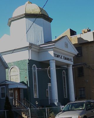
Temple Emanu-El is a Conservative synagogue in Port Richmond, Staten Island, New York. Designed by Pelcher and Zobel and constructed in 1907, its building was listed on the National Register of Historic Places in 2007. The domed, wooden, clapboard-sided synagogue, located in Staten Island is built in Classical style. A pedimented front porch is supported by a pair of columns, a design that repeats inside in the design of the Torah Ark. The modest building is topped by a dome that supports a Star of David. The dome is supported by an octagonal drum. The dome was originally painted gold and is said to have been visible from miles away.
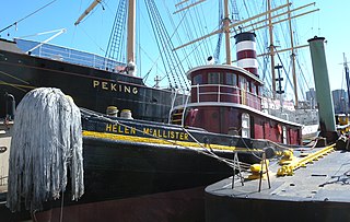
Admiral Dewey, also known as Georgetown and today as Helen McAllister, is a 113 feet (34 m) tugboat built in 1900 at the Burlee Drydock in Port Richmond, New York. She was built with a 900 horsepower (670 kW) triple expansion compound steam engine which was replaced with a diesel engine after World War II. She towed coal barges to refuel ships in the harbor. In 1955, she was sold to a Charleston, South Carolina tugboat company. In the 1980s, the McAllister tugboat company of New York purchased the company and brought the renamed Helen McAllister back to New York harbor. She helped dock tall ships during Op Sail 1992.

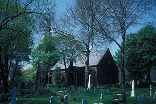
Brighton Heights Reformed Church is a Dutch Reformed church at 320 St. Marks Place in St. George, Staten Island, New York City. It is the second of two church buildings that have stood on the site.
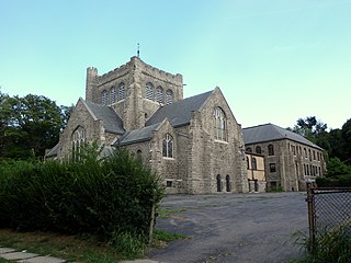
Christ Church New Brighton (Episcopal) is a historic Episcopal church complex at 76 Franklin Avenue in New Brighton, Staten Island, New York. The complex consists of a Late Victorian Gothic church (1904) and parish hall, connected to the church by an enclosed cloister, and a Tudor-style rectory (built 1879 and remodeled in 1909).
The Church of St. Andrew is a historic Episcopal church located at Arthur Kill and Old Mill Roads on the north side of Richmondtown in Staten Island, New York.

St. Paul's Memorial Church is an Anglo-Catholic Episcopal parish in New York City, New York located at 225 St. Paul's Avenue in the Stapleton area of Staten Island.

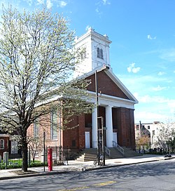
Woodrow Methodist Church is a historic Methodist church at 1109 Woodrow Road in Woodrow, Staten Island, New York. It was built in 1842 and is a wood-frame, clapboard-sided, temple-form Greek Revival style building. It features a portico with four Doric order columns supporting a plain entablature and unadorned pediment. Above the portico is a three-stage, open bell tower and spire in a vernacular Italianate style added in 1876. Also on the property is a two-story clapboard house built about 1850 and expanded in 1860–61.

Caleb T. Ward Mansion is a historic home located at 141 Nixon Avenue on Ward Hill, Staten Island, New York. Caleb Tompkins Ward built the mansion in 1835 with the help of architect George B. David, who built the mansion out of stucco and brick in an imposing Greek Revival style. Ward acquired the land for his mansion in 1826, after his uncle died. His uncle was Daniel D. Tompkins, Governor of New York.
This is a timeline of Staten Island.