
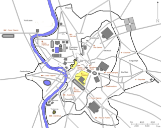
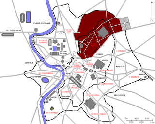
The Regio XIII Aventinus is the thirteenth regio of imperial Rome, under Augustus's administrative reform. Regio XIII took its name from the hill which dominated the region, the Aventine.
The Regio XIII Aventinus is the thirteenth regio of imperial Rome, under Augustus's administrative reform. Regio XIII took its name from the hill which dominated the region, the Aventine.

Regio XIII not only contained the Aventine Hill, but also the plain in front of it. [1] In extent, this region was bordered by the Tiber River to the west, the Circus Maximus to the north, the Vicus Piscinae Publicae and the Via Ostiensis to the east, and the Aurelian Walls to the south. Its principal gate through the walls was the Porta Ostiensis. A measurement taken at the end of the 4th century recorded that the perimeter of the region was 18,000 Roman feet (approximately 5.3 km). [2]

The region contained a number of temples, including the Temple of Diana (reportedly built by the king Servius Tullius), the Temple of Minerva and the Temple of Juno Regina. [3] It also contained several baths, including the Baths of Licinius Sura and the Baths of Decius. In this region, the Armilustrium was also celebrated.
Regio XIII also contained the Emporium , the first port built on the Tiber, and attached to the port were the warehouses of the Horrea Galbae , [4] built around the tomb of Servius Sulpicius Galba, while nearby was the Forum Pistorium . The region also possessed two unusual features still present today: Monte Testaccio, an artificial hill, and the Pyramid of Cestius. At the turn of the 5th century, the Regio contained 17 aediculae (shrines), 130 domūs (patrician houses), 35 horrea (warehouses), 60 balneae (bath houses) and 88 loci (fountains). [5]
At the turn of the 5th century, the Regio was divided into 17 vici (districts) and 2,487 insulae (blocks). It had two curators and was served by 48 Roman magistrates. [6]

Ostia Antica was an ancient Roman city and the port of Rome located at the mouth of the Tiber. It is near modern Ostia, 25 kilometres southwest of Rome. Due to silting and the invasion of sand, the site now lies 3 km (2 mi) from the sea. The name Ostia derives from Latin os 'mouth'.

The Aventine Hill is one of the Seven Hills on which ancient Rome was built. It belongs to Ripa, the modern twelfth rione, or ward, of Rome.
In 7 BC, Augustus divided the city of Rome into 14 administrative regions. These replaced the four regiones—or "quarters"—traditionally attributed to Servius Tullius, sixth king of Rome. They were further divided into official neighborhoods.

The Horrea Galbae were warehouses (horrea) in the southern part of ancient Rome, located between the southern end of the Aventine Hill and the waste dump of Monte Testaccio. They ran for a substantial distance, possibly extending as far as the Porta Ostiensis in the east and the Porticus Aemilia on the banks of the Tiber. The horrea were most likely built on the site of a suburban villa owned by the Sulpicii Galbae, a distinguished noble family of whom the 1st century AD Roman Emperor Galba was a member.
During the Middle Ages, Rome was divided into a number of administrative regions, usually numbering between twelve and fourteen, which changed over time.

The Emporium was the river port of the ancient Rome, that rose approximately between the Aventine Hill and the Rione Testaccio.

The Regio I Porta Capena is the first regio of imperial Rome, under Augustus's administrative reform. Regio I took its name from the Porta Capena, a gate of the Servian Walls, through which the Appian Way entered the city prior to the construction of the Aurelian Walls.

The Regio II Caelimontium is the second regio of imperial Rome, under Augustus's administrative reform. It took its name from the Caelian Hill, which the region was centred on.
The ancient city of Constantinople was divided into 14 administrative regions. The system of fourteen regiones was modelled on the fourteen regiones of Rome, a system introduced by the first Roman emperor Augustus in the 1st century AD.

The Regio III Isis et Serapis was the third regio of imperial Rome, under Augustus's administrative reform. Regio III took its name from the double sanctuary of Isis and Serapis, in the area of the Via Praenestina, containing the valley that was to be the future site of the Colosseum, and parts of the Oppian and Esquiline hills.

The Regio IV Templum Pacis is the fourth regio of imperial Rome, under Augustus's administrative reform. Regio IV took its name from the Temple of Peace built in the region by the emperor Vespasian. It includes the valley between the Esquiline and the Viminal hills, the popular area of the Suburra, and the Velian Hill.

The Regio V Esquiliae is the fifth regio of imperial Rome, under Augustus's administrative reform. Regio V took its name from the Esquiline Hill. It contains parts of the Oppian Hill and Cispian Hill and of the Esquiline, plus the plain just outside the Servian Wall.
The Regio VI Alta Semita is the sixth regio of imperial Rome, under Augustus's administrative reform. Regio VI took its name from the street passing over the Quirinal Hill. It was a large regio that also encompassed the Viminal Hill, the lower slopes of the Pincian, and the valleys in-between.

The Regio VII Via Lata is the seventh regio of imperial Rome, under Augustus's administrative reform. Regio VII took its name from the wide urban street the Via Lata. It was the urban section of the Via Flaminia, which ran between the Servian walls and the Aurelian Walls, and corresponds to the modern Via del Corso. The regio contained part of the Campus Martius on the east of the street plus the Collis Hortulorum, the Pincian Hill.

The Regio VIII Forum Romanum Magnum is the eighth regio of imperial Rome, under Augustus's administrative reform. Regio VIII took its name from the Roman Forum, the political centre of Ancient Rome.

The Regio IX Circus Flaminius is the ninth regio of imperial Rome, under Augustus's administrative reform. Regio IX took its name from the racecourse located in the southern end of the Campus Martius, close to Tiber Island.

The Regio X Palatium is the tenth regio of imperial Rome, under Augustus's administrative reform. Regio X took its name from the Palatine Hill and the imperial palaces located on it.

The Regio XI Circus Maximus is the eleventh regio of imperial Rome, under Augustus's administrative reform. Regio XI took its name from the Circus Maximus, located in the valley between the Palatine and the Aventine hills.

The Regio XII Piscina Publica is the twelfth regio of imperial Rome, under Augustus's administrative reform. Regio XII took its name from the Piscina Publica, a swimming pool that disappeared during the middle imperial period.
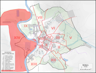
The Regio XIV Transtiberim is the fourteenth regio of imperial Rome, under Augustus's administrative reform. Meaning "across the Tiber", the Regio took its name from its position on the west bank of the Tiber River.
| Authority control databases: Geographic |
|---|