Registrar-General's building

Last updated

Registrar-General's building
Registrar-General's building, Sydney.jpg
The main facade from Prince Albert Road
OSM central Sydney.png
Red pog.svg
Alternative namesLand Titles Office
EtymologyRegistrar-General Department
General information
StatusCompleted
TypeGovernment administration
Architectural style Federation Gothic
Location1 Prince Albert Road, Sydney central business district, New South Wales
CountryAustralia
Coordinates 33°52′12″S151°12′48″E / 33.8699°S 151.2132°E / -33.8699; 151.2132
Current tenants Land and Property Information
Construction started1909
Completed1913
ClientRegistrar-General's Department
Owner Government of New South Wales
Technical details
Material
  • Sandstone-faced
  • Steel-framed construction
  • Reinforced concrete floor
  • Slate covered steel framed roof
Floor count3
Design and construction
Architect(s)
Architecture firm New South Wales Government Architect
Official nameLand Titles Office; Registrar General's Department Building
TypeState heritage (built)
Designated2 April 1999
Reference no.962
TypeAdministration Office
CategoryGovernment and Administration
BuildersLoveridge & Hudson

The Registrar-General's building, also called the Land Titles Office, is a heritage-listed building located in the Sydney central business district, in New South Wales, Australia. The building is currently used by the Land and Property Information division of the Department of Finance, Services and Innovation, part of the Government of New South Wales. It was added to the New South Wales State Heritage Register on 2 April 1999. [1]

Contents

The building is located near the junction of College and Macquarie street and is set in an historical setting on the eastern fringe of the central business district alongside St Mary's Cathedral, Queen's Square, St James' Church, [2] the Sydney Mint, [3] [4] the UNESCO World Heritage Listed Hyde Park Barracks, and Hyde Park.

History

Registrar's Chambers (c.1900) Registrar's Chambers from Hyde Park, Sydney (2633062472).jpg
Registrar's Chambers (c.1900)

The major part of the building is designed by Government Architect Walter Liberty Vernon and completed c.1913. The building contractors and stonework contractors were Loveridge and Hudson. [1] [5] Designed by Vernon in 1908, the building was constructed in stages from 1909 to 1913 to house the Registrar-General's Department, replacing the 1860 Registrar General's Office in Elizabeth Street. The building was used as the central recording point of births, deaths and marriages in the state and the storage of title deeds for the vast majority of the twentieth century. [6]

Description

The western facade, pictured in 2007 Sydney Registrar General's Building.jpg
The western facade, pictured in 2007

A three-storey Neo-Gothic sandstone-faced office building with attic storey and basement, of steel-framed construction with reinforced concrete floor and slate covered steel framed roof. The facades contain some elaborate gothic detailing to windows and good carving work to gables and over entrances. The three large gables facing Prince Albert Road are flanked by castellated corner turrets, whilst the facade to Queen's Square has a similar small gable flanked by two turrets on each side. The initials CH (Colin Hudson, stonemason), are carved into one of the string course bosses at about second-floor level on the western side return wall of the main entrance facing St. Mary's. Nearby on a small octagonal turret are the initials of his father HCH (Herbert Charles Hudson). On the eastern side of the main entrance on the east and west elevations, with initials of the architects and clerks of works. On the keystone of the arch over the main entrance are the entwined numbers 1912. [1] [5]

Modifications and dates

Originally U-shaped, the north side was closed off by an addition in 1953 and further extended in the 1960s. [1] [5]

Heritage listing

The building as viewed from Hyde Park Registrar-General's building (Land Titles Office).jpg
The building as viewed from Hyde Park

As at 6 December 2000, a well scaled civic building sensitively detailed to complement the adjoining older buildings such as St. Mary's Cathedral. Its carefully composed sandstone facade contributes to the streetscape and satisfactorily terminates the northern end of College Street. It provides a sympathetic component in the progression of civic historical buildings along College Street to Queen's Square. The building has long association with the registration of birth, death and marriages, as well as trade marks, bills of sale, business agents etc. The building stores valuable old registers and other land title documents. [1] [5]

Registrar-General's building was listed on the New South Wales State Heritage Register on 2 April 1999. [1]

See also

Related Research Articles

<span class="mw-page-title-main">Richmond, New South Wales</span> Town in New South Wales, Australia

Richmond is a town in New South Wales, in the local government area of the City of Hawkesbury. It is located 19 metres above sea level on the alluvial Hawkesbury River flats, at the foot of the Blue Mountains on the Cumberland Plain. It is about 65 km by road from Sydney and about 78 km by road from Lithgow.

<span class="mw-page-title-main">The Rocks, New South Wales</span> Suburb of Sydney, New South Wales, Australia

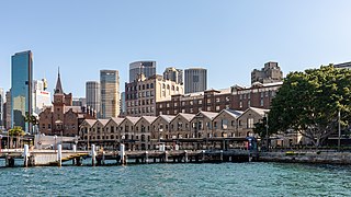
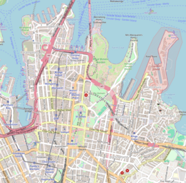
The Rocks is a suburb, tourist precinct and historic area of Sydney's city centre, in the state of New South Wales, Australia. It is located on the southern shore of Sydney Harbour, immediately north-west of the Sydney central business district.

<span class="mw-page-title-main">Francis Greenway</span> Architect

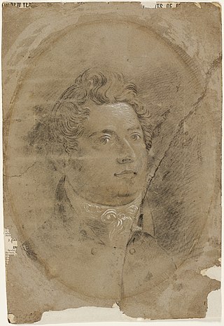
Francis Howard Greenway was an English-born architect who was transported to Australia as a convict for the crime of forgery. In New South Wales he worked for the Governor, Lachlan Macquarie, as Australia's first government architect. He became widely known and admired for his work displayed in buildings such as St Matthew's Church, St James' Church and Hyde Park Barracks.

<span class="mw-page-title-main">Burwood, New South Wales</span> Suburb of Sydney, New South Wales, Australia

Burwood is a suburb in the Inner West of Sydney, in the state of New South Wales, Australia. It is 10 kilometres (6.2 mi) west of the Sydney central business district and is the administrative centre for the local government area of Municipality of Burwood.

<span class="mw-page-title-main">Supreme Court of New South Wales</span> Superior court of New South Wales, Australia

The Supreme Court of New South Wales is the highest state court of the Australian State of New South Wales. It has unlimited jurisdiction within the state in civil matters, and hears the most serious criminal matters. Whilst the Supreme Court is the highest New South Wales court in the Australian court hierarchy, an appeal by special leave can be made to the High Court of Australia.

John Verge (1782–1861) was an English architect, builder, pioneer settler in the Colony of New South Wales, who migrated to Australia and pursued his career there. Verge was one of the earliest and the most important architect of the Greek Revival in Australia. He also brought more comprehensive range of Regency style than any contemporary architects. His design indicates the increasing of sophistication compared to previous architect's design.

<span class="mw-page-title-main">Millers Point, New South Wales</span> Suburb of Sydney, New South Wales

Millers Point is an inner-city suburb of Sydney, in the state of New South Wales, Australia. It is on the north-western edge of the Sydney central business district, adjacent to The Rocks and is part of the local government area of the City of Sydney.

<span class="mw-page-title-main">Sydney Mint</span> Heritage-listed building in Sydney

The Sydney Mint in Sydney, New South Wales, Australia, is the oldest surviving public building in the Sydney central business district. Built between 1811 and 1816 as the southern wing of the Sydney Hospital, it was then known as the Rum Hospital. In 1854 a mint was established on the site with the hospital building used to house mint staff as well as providing a residence for the Deputy Mint Master. A coining factory was built at the rear. Both of these structures have exceptional heritage significance and have been associated with major events in the colonial history of New South Wales.

<span class="mw-page-title-main">Walter Liberty Vernon</span>

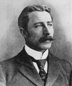
Colonel Walter Liberty Vernon was an English architect who migrated to Australia and pursued his career as an architect in Sydney, New South Wales. In his role as the New South Wales Government Architect he is noted for designing multiple government buildings, many of which are extant with listings on national and state heritage registers.

<span class="mw-page-title-main">Queen's Square, Sydney</span> Public square in Sydney, Australia

Queen's Square is a public square in central Sydney, Australia. The square is located at the junction of King Street with Phillip Street and Macquarie Street. It is bounded on the south by St James Road and Prince Albert Road.

<span class="mw-page-title-main">Mortimer Lewis</span>

Mortimer William Lewis was an English-born architect, surveyor and public servant who migrated to Australia and became Colonial Architect in the colony of New South Wales from 1835 to 1849. Lewis was responsible for designing and overseeing many government buildings in Sydney and rural New South Wales, many of which are heritage listed.

<span class="mw-page-title-main">George McRae</span>

George McRae was a Scottish-Australian architect who migrated from his native Edinburgh to Sydney, where he became Government Architect of New South Wales and designed some of Sydney's best-known buildings, including completion of the Sydney Town Hall, the Queen Victoria Building, and the lower entrance to Taronga Zoo.

<span class="mw-page-title-main">Bridge Street, Sydney</span> Street in Sydney, Australia

Bridge Street is a street in the central business district of Sydney in New South Wales, Australia. Bridge Street runs for 500 metres (1,600 ft) in a west–east direction with traffic flowing in both directions. It is situated in the northern portion of the central business district. The western terminus of Bridge Street is at George Street, with the eastern terminus at Macquarie Street, adjacent to the Chief Secretary's Building. From west to east, Bridge Street crosses Pitt and Phillip streets.

<span class="mw-page-title-main">York Street, Sydney</span> Street in Sydney, Australia

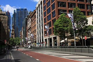
York Street is a street in the Sydney central business district in New South Wales, Australia. York Street runs 1.050 kilometres (0.652 mi) in a north to south direction only and is used predominantly by buses from the northern districts of Sydney.

<span class="mw-page-title-main">Armidale Regional Council</span> Local government area in New South Wales, Australia

The Armidale Region is a local government area in the New England and Northern Tablelands regions of New South Wales, Australia. This area was formed in 2016 from the merger of the Armidale Dumaresq Shire with the surrounding Guyra Shire.

<span class="mw-page-title-main">Old Registry Wing (Supreme Court of New South Wales)</span> Former registry office in the Supreme Court House group

The Old Registry Office of the Supreme Court of New South Wales is a heritage-listed courthouse at the corner of Elizabeth Street and St James Road, in the Sydney central business district in the City of Sydney local government area of New South Wales, Australia. It was designed by Government Architect Alexander Dawson and James Barnet and built from 1859 to 1862. It is also known as Sydney Supreme Court House. The property is owned by the Department of Justice, a department of the Government of New South Wales. It was added to the New South Wales State Heritage Register on 2 April 1999.

<span class="mw-page-title-main">Cammeray Substation</span> Electrical substation in Australia

The Cammeray Substation is a heritage-listed electrical substation at 143 Bellevue Street, Cammeray, North Sydney Council, New South Wales, Australia. It was built during 1915. It is also known as Substation - Bellevue, Cammeray and #77 Pine Street. It was added to the New South Wales State Heritage Register on 2 April 1999.

<span class="mw-page-title-main">Ultimo Post Office</span> Historic site in New South Wales, Australia

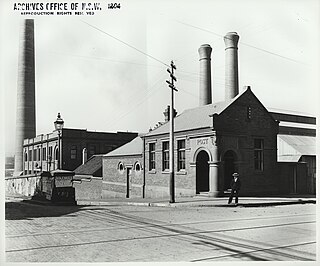
The Ultimo Post Office is a heritage-listed former post office located at 494 Harris Street in the inner city Sydney suburb of Ultimo in the City of Sydney local government area of New South Wales, Australia. The property is owned by Trustees of the Museum of Applied Arts and Science, an agency of the Government of New South Wales. It was added to the New South Wales State Heritage Register on 2 April 1999.

<span class="mw-page-title-main">National House</span> Historic building in Sydney

National House is a heritage-listed former warehouse and bank branch and now pub located at 75 York Street, on the corner of King Street, in the Sydney central business district, in the City of Sydney local government area of New South Wales, Australia. It now operates as the Hotel CBD. It was added to the New South Wales State Heritage Register on 2 April 1999.

References

  1. 1 2 3 4 5 6 "Land Titles Office". New South Wales State Heritage Register . Department of Planning & Environment. H00962. Retrieved 13 October 2018. CC BY icon.svg Text is licensed by State of New South Wales (Department of Planning and Environment) under CC-BY 4.0 licence .
  2. "St. James' Anglican Church". New South Wales State Heritage Register . Department of Planning & Environment . Retrieved 17 November 2013. CC BY icon.svg Text is licensed by State of New South Wales (Department of Planning and Environment) under CC-BY 4.0 licence .
  3. "Mint Building". New South Wales State Heritage Register . Department of Planning & Environment . Retrieved 25 October 2017. CC BY icon.svg Text is licensed by State of New South Wales (Department of Planning and Environment) under CC-BY 4.0 licence .
  4. "Mint Building and Hyde Park Barracks Group". New South Wales State Heritage Register . Department of Planning & Environment . Retrieved 25 October 2017. CC BY icon.svg Text is licensed by State of New South Wales (Department of Planning and Environment) under CC-BY 4.0 licence .
  5. 1 2 3 4 DLWC, S170 Register.
  6. Blair, Peter; Ticehurst, Frank; Baalman, John; Wells, Theodore Le Mare (2015). "Land titles office practice NSW". Sydney: Thomson Reuters (Professional) Australia Limited. Retrieved 27 October 2017.

Bibliography

Attribution

CC BY icon-80x15.png This Wikipedia article contains material from Land Titles Office , entry number 962 in the New South Wales State Heritage Register published by the State of New South Wales (Department of Planning and Environment) 2018 under CC-BY 4.0 licence , accessed on 13 October 2018.

Further reading