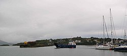
Cobh, known from 1849 until 1920 as Queenstown, is a seaport town on the south coast of County Cork, Ireland. With a population of around 13,000 inhabitants, Cobh is on the south side of Great Island in Cork Harbour and home to Ireland's only dedicated cruise terminals. Tourism in the area draws on the maritime and emigration legacy of the town.

Ringaskiddy is a village in County Cork, Ireland. It is located on the western side of Cork Harbour, south of Cobh, and is 15 kilometres from Cork city, to which it is connected by the N28 road. The village is a port with passenger ferry services to France. A ferry service to Swansea in Wales closed in 2012.

Rylane Cross is a village in County Cork, Ireland. The town is situated roughly midway between Millstreet and Cork city, north of Macroom in the Parish of Aghabullogue.

Cork Harbour is a natural harbour and river estuary at the mouth of the River Lee in County Cork, Ireland. It is one of several which lay claim to the title of "second largest natural harbour in the world by navigational area". Other contenders include Halifax Harbour in Canada, Trincomalee Harbour in Sri Lanka and Poole Harbour in England.

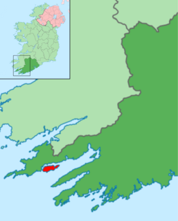
Bantry Bay is a bay located in County Cork, Ireland. The bay runs approximately 35 km (22 mi) from northeast to southwest into the Atlantic Ocean. It is approximately 3-to-4 km wide at the head and 10 km (6.2 mi) wide at the entrance.

Great Island is an island in Cork Harbour, at the mouth of the River Lee and close to the city of Cork, Ireland. The largest town on the island is Cobh. The island's economic and social history has historically been linked to the naval, ship-building, and shipping activities in the town's environs.
Bere Island (Irish: Oiléan Béarra, meaning "bear island", although officially called An tOileán Mór meaning "the big island") is an island off the Beara Peninsula in County Cork, Ireland. It is roughly 10 km x 3 km in dimension, with an area of 17.68 km², and, as of 2012, had a population of between 210 and 220 people.

Spike Island is an island of 103 acres (42 ha) in Cork Harbour, Ireland. Originally the site of a monastic settlement, the island is dominated by an 18th-century bastion fort now named Fort Mitchel.

Glenbrook is a village in the townland of Lackaroe, between Passage West and Monkstown in County Cork, Ireland. Monkstown, Glenbrook and Passage West are three villages along Cork Harbour's R610 route. The Cross River Ferry at Glenbrook links the Owenabue Valley with East Cork, Fota Island and Cobh.

The South-West Region is a NUTS Level III statistical region of Ireland. It consists of the territory of Cork City, the regional capital, as well as the counties of Cork and Kerry. The South-West region spans 12,161 km2, roughly 16% of the total area of the state and according to the 2016 census has a population of 689,750.

Little Island, County Cork, is a civil parish and mainly industrial area to the east of Cork city in Ireland. It is no longer an island, since the northern channel separating it from the mainland has filled over. To the west and south is Lough Mahon, part of Cork Harbour; across a channel to the east is Fota Island. Little Island is part of the Cork North-Central.
The Cork Under-21 Football Championship is a Gaelic football competition in County Cork, Ireland for players under the age of 21. Clubs affiliated to Cork board compete to win this championship. All eight of the divisions in Cork organize their own championship. The divisional winners compete against each other to decide the county title.
Lawrence Cove is a sheltered inlet on the north side of Bere Island, West Cork, Ireland, to the west of the village of Rerrin.
The Swansea Cork ferry was a 10-hour ferry crossing that linked Swansea in South Wales with the Port of Cork in Ireland. The ferry route was last operated by Fastnet Line from 2010 to 2012, although no commercial passenger sailings took place after 2011. Between 1987 and 2006 the service was operated by Swansea Cork Car Ferries Ltd. Prior to the revival of the Cork–Swansea route by Swansea Cork Car Ferries Ltd. the former Irish semi-state owned ferry company, British & Irish Steam Packet Company which became known simply as the B+I Line which had operated the route from 1969 until 1979. In 1979 the B+I Line decided to switch the Cork–Swansea service over to a Cork–Pembroke Dock service instead. Prior to B+I Line's Cork Swansea ferry, they had a previous ferry service that sailed from Cork to Fishguard in South Wales. Over the years numerous ships had different departure points from Cork. Originally, the ferry came right up into Cork city centre and would have docked across from Penrose House at Penrose Quay and in the 1970s ferries departed Cork from a new Ferry Terminal based down stream at Tivoli Docks alongside a large container terminal. From around the early 1980s onwards ferries would later depart from yet another new passenger car Ferry Terminal based at Ringaskiddy Deepwater Berth in the lower part of Cork Harbour.

The Port of Cork is the main port serving the South of Ireland, County Cork and Cork City. It offers all six shipping modes. In 2015, over 11 million tonnes of freight were shipped through the Port of Cork, making it Ireland’s second busiest port. As well as its berths upriver at Cork City, the port also includes other major locations across Cork Harbour, including Tivoli loading docks in the eastern suburbs, Cobh on the south of Great Island and Ringaskiddy on the west side of the harbour.

The 1st Brigade is a brigade of the Irish Army. The brigade, which was known as 1st (Southern) Brigade until the 2012 reorganisation of the army, has its headquarters in Collins Barracks in Cork. The 1st Brigade is responsible for military operations in the south of Ireland. Its area of responsibility includes the counties of Galway, Offaly, Laois, Carlow, Kilkenny, Wexford, Waterford, Cork, Kerry, Limerick and Tipperary.

East Ferry is an area of East Cork overlooking Cork Harbour in Ireland. The area takes its name from a ferry which historically crossed the channel separating Garranekinnefeake promontory from Great Island.
Bear is a barony in the most westerly part of County Cork, Ireland. It comprises approximately two thirds of the Beara peninsula from the western tip along the whole northern shore part of Bantry bay to Glengariff. The remaining third to the north-east is the neighbouring barony of Glanarought in County Kerry. The barony's only other neighbour is that of Bantry to the east. To the north, it is bounded by the Kenmare River
MV Eilean Na H-Oige is a small passenger ferry built for the Outer Hebrides and now operating in Southern Ireland.