Related Research Articles

Inyo County is a county in the eastern central part of the U.S. state of California, located between the Sierra Nevada and the state of Nevada. In the 2020 census, the population was 19,016. The county seat is Independence. Inyo County is on the east side of the Sierra Nevada and southeast of Yosemite National Park in Central California. It contains the Owens River Valley; it is flanked to the west by the Sierra Nevada and to the east by the White Mountains and the Inyo Mountains. With an area of 10,192 square miles (26,400 km2), Inyo is the second-largest county by area in California, after San Bernardino County. Almost one-half of that area is within Death Valley National Park. However, with a population density of 1.8 people per square mile, it also has the second-lowest population density in California, after Alpine County.
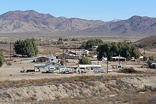
Tecopa is a census-designated place (CDP) in the Mojave Desert in southeast Inyo County, California, United States. Originally occupied by the Koso and Chemehuevi Indians, Whites began populating what would become the CDP in the late 19th century to support nearby mines. It is now better known for the natural hot springs in the northern part of the CDP. It was the subject of an article by John Gregory Dunne published in the Saturday Evening Post and reprinted in Dunne's book, Quintana & Friends, published by Dutton in 1978.

Area codes 760 and 442 are telephone area codes in the North American Numbering Plan (NANP) for the U.S. state of California. These area codes serve an overlay complex that comprises much of the southeastern and southernmost portions of California. It includes Imperial, Inyo, and Mono counties, as well as portions of San Diego, Riverside, San Bernardino, Los Angeles and Kern counties. Area code 760 was created on March 22, 1997 in a split of area code 619. Area code 442 was added to the same area on November 21, 2009.

The Mojave Road, also known as Old Government Road, is a historic route and present day dirt road across what is now the Mojave National Preserve in the Mojave Desert in the United States. This rough road stretched 147 miles (237 km) from Beale's Crossing, to Fork of the Road location along the north bank of the Mojave River where the old Mojave Road split off from the route of the Old Spanish Trail/Mormon Road.

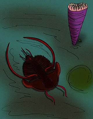
Nephrolenellus is an extinct genus of trilobite, fossil marine arthropods, of relatively small size. Currently two species are attributed to it. Nephrolenellus lived at the end of the Lower Cambrian. Species are known from the Great Basin of California, Nevada and Arizona, with one specimen from Canada.
Narka is a former settlement in Inyo County, California. It was located on the Southern Pacific Railroad about 3.5 miles (5.6 km) south of the current settlement of Little Lake. Narka, also known as siding 20, was created in February 1909 to support construction of the Los Angeles Aqueduct camp at Soda Hill. Narka began as a railroad camp before Little Lake was settled. A post office operated at Narka from 1909 to 1913, when the service was transferred to Little Lake. Narka was abandoned on March 15, 1935.
Sodan is a former settlement in Inyo County, California. It was located on the Southern Pacific Railroad about halfway between Narka and Little Lake.
San Carlos is a former settlement in Inyo County, California. It was founded in 1863 and was located on the east bank of the Owens River 4 miles (6.4 km) east of Independence, close by to the west of the later site of Kearsarge, California.
Wheeler Crest is a small residential unincorporated community in southwestern Mono County, California. It functions as a bedroom community for workers in Bishop and Mammoth Lakes, and as a home for retirees. Geographically, it sits on the Sherwin Grade, which divides Round Valley in Inyo County from Long Valley in Mono County.
Noonday Camp, also known as Mill City, Noonday City, and Tecopa, is a ghost town located in the Mojave Desert east of Tecopa in Inyo County, California.
The Nelson Range is a subrange of the Selkirk Mountains in the West Kootenay region of British Columbia, Canada. It is located south of the west arm of Kootenay Lake between the Salmo (W) and Kootenay Rivers (E) and also to the west of the south arm of Kootenay Lake. The range gets its name from the City of Nelson, which is on the south bank of the West Arm of Kootenay Lake and at the foot of the range's northwestern slopes.
Peachella is an extinct genus of trilobites, fossil marine arthropods, with species of average size. It lived during the Toyonian stage, 516 to 513 million years ago, in what is today the southwestern United States. It can easily be distinguished from other trilobites by its club-like genal spines.

Bristolia is an extinct genus of trilobite, fossil marine arthropods, with eight or more small to average size species. It is common in and limited to the Lower Cambrian shelf deposits across the southwestern US, which constitutes part of the former paleocontinent of Laurentia.
White Mountain City (WMC) is a ghost town at the mouth of Wyman Canyon in Deep Springs Valley in Inyo County, California. The site is on a dirt road east of CA-168 near the Nevada border. Today, White Mountain City is marked by some ruins.
Death Valley Academy, also known as Death Valley High Academy, is a public high school located in the town of Shoshone in Inyo County, California. It is part of the Death Valley Unified School District. It is accredited by the Western Association of Schools and Colleges, most recently in April 2013. The school mascot is the Scorpions.
Pink Arrow is an unincorporated community in Navajo County, Arizona, United States. Pink Arrow is located at 35°46′37″N110°09′26″W.
Wilson Pass is a gap in Clark County, Nevada. It lies at an elevation of 5033 feet in the Spring Mountains between Goodsprings Valley and Mesquite Valley.
Chicago Valley is a valley in Inyo County, California. The head of Chicago Valley lies at 36°07′25″N116°10′39″W and runs south to its mouth that lies at an elevation of 2,028 feet / 618 meters in the vicinity of Resting Springs where it meets the Greenwater Valley. The Chicago Valley lies between the Resting Spring Range on the west and the Nopah Range on the east and north.
Emigrant Pass, is a gap in the Nopah Range of Inyo County, California. It lies at an elevation of 2,884 feet (879 m) in the Nopah Range between Chicago Valley to the west and California Valley to the east.

White Sulphur is an unincorporated community in Delaware County, in the U.S. state of Ohio.
References
35°52′39″N116°09′26″W / 35.87750°N 116.15722°W
| | This Inyo County, California-related article is a stub. You can help Wikipedia by expanding it. |
| | This American Old West-related article is a stub. You can help Wikipedia by expanding it. |
| | This article relating to the history of the United States is a stub. You can help Wikipedia by expanding it. |