Restonica

Last updated
Restonica
Riviere-restonica.jpg
Restonica river
Corse region relief location map.jpg
Red pog.svg
France relief location map.jpg
Red pog.svg
Location
Country France
Region Corsica
Department Haute-Corse
Canton Corte
Physical characteristics
Mouth Tavignano
  location
Corte
  coordinates
42°18′14″N9°09′12″E / 42.30389°N 9.15333°E / 42.30389; 9.15333
Basin features
Progression TavignanoTyrrhenian Sea

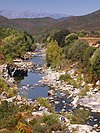
The Restonica is a small river in the department of Haute-Corse, Corsica, France. It is a tributary of the river Tavignano. The river has a steep and rocky course with many pools and waterfalls. The valley contains two lakes, and is a popular tourist destination.

Contents

Course

The Restonica is 17.79 kilometres (11.05 mi) long. [1] It rises to the north of the 2,342 metres (7,684 ft) Punta Muzzella in the canton of Corte. It originates in the Lac de Melu. The river continues in a northeast direction to join the Tavignano in the town of Corte. The Lac de l'Oriente to the north of the 2,622 metres (8,602 ft) Monte Rotondo, drains through the Ruisseau de Lamento or Timozzo, a tributary of the Restonica. The small Lac de Pozzolo to the east of Monte Rotondo drains through the Ruisseau de Pozzolo, a tributary of the Ruisseau de Rivesecco, another tributary of the Restonica. The D623 road follows the river for most of its course. [2]

Tourism

Lakes Capitello and Melo Corse GR20 Lac de Melo et Capitello.jpg
Lakes Capitello and Melo

The valley lies in the Monte Rotondo massif and contains Lac de Melu at 1,711 metres (5,614 ft) and Lac de Capitellu at 1,930 metres (6,330 ft). It is accessible by the narrow and winding D623, which extends up to the Bergeries de Grutelle. In 2009 the municipality of Corte developed a plan to reconcile its protection, development and tourist exploitation. The Restonica Valley is an important source of tourist income for central Corsica and has been a listed site since 1966. Tourists may visit to contemplate the scenery, to swim in its clear waters, or to access the high mountains via the GR20 trails. [3] It can be very busy in the high season. [4]

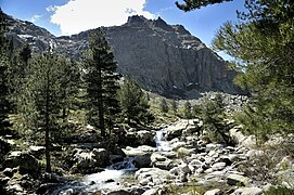
The banks of the river are lined with pines. The course of the river is dotted with waterfalls and deep natural basins carved into the granite that visitors can use to cool off during the heat of summer. A marked trail leads from the Bergeries de Grotelle at the end of the D623 to Lac de Melo, a hike of about an hour. The lake covers about 6.5 hectares (16 acres) and is no more than 20 metres (66 ft) deep. It is frozen for half the year. Lake Capitello is higher up and can be reached with another one-hour walk up a much harder trail. It is 340 by 250 metres (1,120 by 820 ft) and covers 5.5 hectares (14 acres). It is the deepest lake in Corsica with a maximum depth of 42 metres (138 ft) and stays frozen for more than eight months each year. [4]

Tributaries

The following streams (ruisseaux) are tributaries of the Restonica (ordered by length) and sub-tributaries:

Notes

    1. La Restonica, Sandre.
    2. Relation: La Restonica (2892937).
    3. La vallée de la Restonica, Office de Tourisme.
    4. 1 2 Moreau 2021.

    Sources

    Related Research Articles

    <span class="mw-page-title-main">Tavignano</span> River in the department of Haute-Corse, Corsica

    The Tavignano is a river on the island of Corsica, France.

    <span class="mw-page-title-main">Lac de Melu</span> Lake in Corsica, France

    Lac de Melu is a lake in Corsica, France. At an elevation of 1,710 metres (5,610 ft), its surface area is 0.065 square kilometres (0.025 sq mi). The lake is the source of the Restonica River.

    <span class="mw-page-title-main">Lac de l'Oriente</span>

    Lac de l'Oriente is a lake in Corsica, France.

    <span class="mw-page-title-main">Liamone (river)</span> River in Corsica, France

    The Liamone river is a river of Corsica, France. The river gave its name to the former French department of Liamone. In antiquity, it bore the Latin name Circidius.

    <span class="mw-page-title-main">Monte Rotondo</span>

    Monte Rotondo is a mountain in the department of Haute-Corse on the island of Corsica, France. At 2,622 metres (8,602 ft) it is the second highest in Corsica, after Monte Cinto. It is the highest point on the Monte Rotondo massif.

    <span class="mw-page-title-main">Tartagine</span> River in the department of Haute-Corse, Corsica

    The Tartagine is a river in the department of Haute-Corse, Corsica, France. It flows through the Monte Cinto massif. It is a tributary of the Asco, which in turn is a tributary of the Golo.

    <span class="mw-page-title-main">Vecchio (river)</span> River in the department of Haute-Corse, Corsica

    The Vecchio is a river in the department of Haute-Corse, Corsica, France. It is a tributary of the river Tavignano.

    <span class="mw-page-title-main">Figarella</span> River in the department of Haute-Corse, Corsica

    The Figarella is a small coastal river in the northwest of the department of Haute-Corse, Corsica, France.

    <span class="mw-page-title-main">Sisco (stream)</span> Stream in the department of Haute-Corse, Corsica

    The Sisco is a small coastal stream in the department of Haute-Corse, Corsica, France. It enters the Tyrrhenian Sea from the east of the Cap Corse peninsula.

    <span class="mw-page-title-main">Erco (river)</span> River in France

    The Erco is a stream in the department of Haute-Corse, Corsica, France. It is a tributary of the Golo.

    <span class="mw-page-title-main">Oso (river)</span> River in Corsica, France

    The Oso is a small coastal river in the southeast of the department of Corse-du-Sud, Corsica, France.

    <span class="mw-page-title-main">Prunelli</span> River in Corsica, France

    The Prunelli is a small coastal river in the department of Corse-du-Sud, Corsica, France. It flows into the Golfe d'Ajaccio on the Mediterranean Sea.

    <span class="mw-page-title-main">Ese (river)</span> River in Corsica, France

    The Ese is a river in the department of Corse-du-Sud, Corsica, France. It is a tributary of the Prunelli river, which it joins in the Lac de Tolla.

    The Canella is a coastal stream in the south of the department of Corse-du-Sud, Corsica, France. It has ecologically interesting wetlands at its mouth.

    The Lava is a coastal stream in the west of the department of Corse-du-Sud, Corsica, France.

    <span class="mw-page-title-main">Guagno (river)</span> River in Corsica, France

    The Guagno is a river in the north of the department of Corse-du-Sud, Corsica, France. It is a tributary of the river Liamone.

    <span class="mw-page-title-main">Seccu</span> Stream in the department of Haute-Corse, Corsica

    The Seccu River is a small coastal river in the department of Haute-Corse, Corsica, France.

    <span class="mw-page-title-main">Varagno</span> Stream in the department of Haute-Corse, Corsica

    The Varagno is a stream in the department of Haute-Corse, Corsica, France. It is a tributary of the Fiumorbo.

    <span class="mw-page-title-main">Col de San Quilico</span> Mountain pass in Corsica, France

    The Col de San Quilico or collo di San Quilico is a mountain pass in the Haute-Corse department of Corsica, France. It is a road pass on Territorial Route 20, between Corte and Ponte Leccia (Morosaglia).