Related Research Articles

The Lewis and Clark Expedition, also known as the Corps of Discovery Expedition, was the United States expedition to cross the newly acquired western portion of the country after the Louisiana Purchase. The Corps of Discovery was a select group of U.S. Army and civilian volunteers under the command of Captain Meriwether Lewis and his close friend Second Lieutenant William Clark. Clark, along with 30 others, set out from Camp Dubois, Illinois, on May 14, 1804, met Lewis and ten other members of the group in St. Charles, Missouri, then went up the Missouri River. The expedition crossed the Continental Divide of the Americas near the Lemhi Pass, eventually coming to the Columbia River, and the Pacific Ocean in 1805. The return voyage began on March 23, 1806, at Fort Clatsop, Oregon, ending six months later on September 23 of that year.

The Cascade Range or Cascades is a major mountain range of western North America, extending from southern British Columbia through Washington and Oregon to Northern California. It includes both non-volcanic mountains, such as many of those in the North Cascades, and the notable volcanoes known as the High Cascades. The small part of the range in British Columbia is referred to as the Canadian Cascades or, locally, as the Cascade Mountains. The highest peak in the range is Mount Rainier in Washington at 14,411 feet (4,392 m).
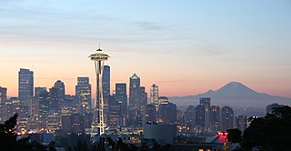
The Pacific Northwest, sometimes referred to as Cascadia, is a geographic region in Western North America bounded by its coastal waters of the Pacific Ocean to the west and, loosely, by the Rocky Mountains to the east. Though no official boundary exists, the most common conception includes the U.S. states of Oregon, Washington, Idaho, and the Canadian province of British Columbia. Some broader conceptions reach north into Alaska and Yukon, south into northern California, and east into western Montana. Other conceptions may be limited to the coastal areas west of the Cascade and Coast mountains.
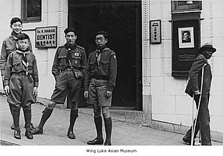
Scouting in the US state of Washington officially began in the 1910s.

Meriwether Lewis was an American explorer, soldier, politician, and public administrator, best known for his role as the leader of the Lewis and Clark Expedition, also known as the Corps of Discovery, with William Clark. Their mission was to explore the territory of the Louisiana Purchase, establish trade with, and sovereignty over the natives near the Missouri River, and claim the Pacific Northwest and Oregon Country for the United States before European nations. They also collected scientific data and information on indigenous nations. President Thomas Jefferson appointed him Governor of Upper Louisiana in 1806. He died in 1809 of gunshot wounds, in what was either a murder or suicide.

The Columbia River Gorge is a canyon of the Columbia River in the Pacific Northwest of the United States. Up to 4,000 feet (1,200 m) deep, the canyon stretches for over eighty miles (130 km) as the river winds westward through the Cascade Range, forming the boundary between the state of Washington to the north and Oregon to the south. Extending roughly from the confluence of the Columbia with the Deschutes River in the east down to the eastern reaches of the Portland metropolitan area, the water gap furnishes the only navigable route through the Cascades and the only water connection between the Columbia Plateau and the Pacific Ocean. It is thus that the routes of Interstate 84, U.S. Route 30, Washington State Route 14, and railroad tracks on both sides run through the gorge.
Fort Hall was a fort in the Western United States that was built in 1834 as a fur trading post by Nathaniel Jarvis Wyeth. It was located on the Snake River in the eastern Oregon Country, now part of present-day Bannock County in southeastern Idaho. Wyeth was an inventor and businessman from Boston, Massachusetts, who also founded a post at Fort William, in present-day Portland, Oregon, as part of a plan for a new trading and fisheries company. In 1837, unable to compete with the powerful British Hudson's Bay Company, based at Fort Vancouver, Wyeth sold both posts to it. Great Britain and the United States both operated in the Oregon Country in these years.
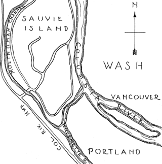
Sauvie Island is in the U.S. state of Oregon, originally named as Wapato Island or Wappatoo Island. It is the largest island along the Columbia River, at 24,000 acres (9,712 ha), and one of the largest river islands in the United States. It lies approximately ten miles northwest of downtown Portland, between the Columbia River to the east, the Multnomah Channel to the west, and the Willamette River to the south. A large portion of the island is designated as the Sauvie Island Wildlife Area. Sturgeon Lake, in the north central part of the island, is the most prominent water feature. The land area is 32.75 square miles (84.8 km2), or 20,959 acres (8,482 ha). Most of the island is in Multnomah County, but the northern third is in Columbia County. The Wapato Bridge provides access across the Multnomah Channel from U.S. Route 30 and was completed in June 2008, replacing the first bridge to connect the island to the mainland which was opened on December 30, 1950.

Fort Clatsop was the encampment of the Lewis and Clark Expedition in the Oregon Country near the mouth of the Columbia River during the winter of 1805–1806. Located along the Lewis and Clark River at the north end of the Clatsop Plains approximately 5 miles (8.0 km) southwest of Astoria, the fort was the last encampment of the Corps of Discovery, before embarking on their return trip east to St. Louis.
This is the timeline of the Lewis and Clark Expedition through the American West, 1803–1806.
The Multnomah are a tribe of Chinookan people who live in the area of Portland, Oregon, in the United States. Multnomah villages were located throughout the Portland basin and on both sides of the Columbia River. The Multnomah speak a dialect of the Upper Chinookan language in the Oregon Penutian family.
The Lewis and Clark National Historical Park, located in the vicinity of the mouth of the Columbia River, commemorates the Lewis and Clark Expedition. Administration of the park, which includes both federal and state lands, is a cooperative effort of the National Park Service and the states of Oregon and Washington. The National Historical Park was dedicated on November 12, 2004.

The Lewis and Clark National Historic Trail is a route across the United States commemorating the Lewis and Clark Expedition of 1804 to 1806. It is part of the National Trails System of the United States. It extends for some 4,900 miles (7,900 km) from Pittsburgh, Pennsylvania, to the mouth of the Columbia River in Oregon.

Cape Disappointment State Park is a public recreation area on Cape Disappointment, located southwest of Ilwaco, Washington, on the bottom end of Long Beach Peninsula, the northern headlands where the Columbia River meets the Pacific Ocean. The state park's 2,023 acres (819 ha) encompass a diverse landscape of old-growth forest, freshwater lakes, freshwater and saltwater marshes, and oceanside tidelands. Park sites include Fort Canby, the Lewis and Clark Interpretive Center, North Head Lighthouse, and Cape Disappointment Lighthouse. Cape Disappointment is one of several state parks and sites in Washington and Oregon that are included in Lewis and Clark National Historical Park.

The Long Beach Peninsula is an arm of land on the southern coast of the state of Washington in the United States. Entirely within Pacific County, it is bounded on the west by the Pacific Ocean, the south by the Columbia River, and the east by Willapa Bay. Leadbetter Point State Park and Willapa National Wildlife Refuge are at the northern end of the peninsula and Cape Disappointment is at the southern end, with Pacific Pines State Park located in between.
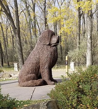
Seaman, a Newfoundland dog, was a member of the Lewis and Clark Expedition, the first trip from the Mississippi River to the Pacific coast and back. He was the only animal to complete the entire three-year trip.

Comcomly (1765–1830) was a Native American leader of the Lower Chinook, a group of Chinookan peoples indigenous to the Pacific Northwest, who inhabited the area near Ilwaco, Washington. Concomly spoke Lower Chinook and was known for his skill with diplomacy and trade.
Dismal Nitch is the name of a cove along the lower Columbia River in Washington state, notable as the Lewis and Clark Expedition's last campsite before sighting the Pacific Ocean.
Clark's Tree is a bronze memorial sculpture in Long Beach, Washington commemorating Lewis and Clark's journey across North America. It sits on a dune above the Pacific Ocean beach at Breakers near where Clark carved a message on a living tree to establish United States precedence of discovery and occupation in what was then the Oregon Country. The memorial was created by Stanley Wanlass, a sculptor educated at Brigham Young University. The sculpture marks the westernmost and northernmost point of Lewis and Clark's journey on the Pacific coast.

Northwest Oregon is a geographic and cultural region of the U.S. state of Oregon, composed of Clatsop, Columbia, and Tillamook counties. The region encompasses the northernmost parts of the state along the lower Columbia River.
References
- ↑ Dean Baker (December 6, 2002). "His colorful past helps author track Lewis and Clark". The Columbian . Archived from the original on June 11, 2014. Retrieved April 27, 2012.
- ↑ Jon Hahn (August 30, 2001). "Long Beach is discovering its historic place along the Lewis and Clark trail". Seattle Post-Intelligencer . Archived from the original on January 25, 2013. Retrieved April 27, 2012.
- ↑ Claudia Rowe (February 2, 2004). "On the money trail 200 years later hoping to reap benefits, Long Beach peninsula plays up ties to Lewis and Clark". Seattle Post-Intelligencer . Archived from the original on January 25, 2013. Retrieved April 27, 2012.
- ↑ Thomas W. Haines (February 22, 1999). "Controversy blurs path of Lewis, Clark". The Boston Globe . Archived from the original on June 11, 2014. Retrieved April 27, 2012.
- ↑ Staff writer (March 15, 2000). "Dollars, pride at stake in Lewis and Clark history debate" . Associated Press . Retrieved April 27, 2012.
- ↑ "Parks Bills:Rex Ziak". Federal Document Clearing House. May 20, 2004. Archived from the original on March 27, 2016. Retrieved April 27, 2012.
- ↑ Lewis and Clark: Down and Up the Columbia River (Moffitt House Press, 2005)
- ↑ Nancy Butterfield (November 6, 2002). "Rex on ice: Local cinematographer's latest adventure airs Friday" . Chinook Observer. Retrieved April 27, 2012.