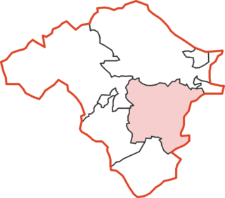
Powys is a county and preserved county in Wales. It borders Gwynedd, Denbighshire, and Wrexham to the north; the English ceremonial counties of Shropshire and Herefordshire to the east; Monmouthshire, Blaenau Gwent, Merthyr Tydfil, Caerphilly, Rhondda Cynon Taf, and Neath Port Talbot to the south; and Carmarthenshire and Ceredigion to the west. The largest settlement is Newtown, and the administrative centre is Llandridnod Wells.

Radnorshire is one of the thirteen historic counties of Wales and a former administrative county. It covers a sparsely populated area in mid Wales. The historic county was bounded to the north by Montgomeryshire and Shropshire, to the east by Herefordshire, to the south by Brecknockshire and to the west by Cardiganshire.

Rural districts were a type of local government area – now superseded – established at the end of the 19th century in England, Wales, and Ireland for the administration of predominantly rural areas at a level lower than that of the administrative counties.
Maelor was a rural district in the administrative county of Flintshire, Wales, from 1894 to 1974. The area approximated to the hundred of Maelor or English Maelor, and was notable for forming a detached part of the county, surrounded by Cheshire, Denbighshire and Shropshire. The administrative centre was located at Overton.

Banbury was a rural district in Oxfordshire, England from 1894 to 1974. It was formed under the Local Government Act 1894 from the bulk of the Banbury rural sanitary district, which had been divided among three counties. The Warwickshire part of the rural sanitary district formed the Farnborough Rural District, whilst the area in Northamptonshire formed the Middleton Cheney Rural District.

The District of Radnorshire was one of three local government districts of the county of Powys, Wales, from 1974 until 1996. The district had an identical area to the previous administrative county of Radnorshire. The district was abolished in 1996, with Powys County Council taking over its functions.
Gwyrfai was a rural district in the administrative county of Caernarvonshire from 1894 to 1974.
Ogwen was a rural district in the administrative county of Caernarfonshire in Wales from 1894 to 1974.
Doncaster was a rural district in the West Riding of Yorkshire, England from 1894 to 1974.

Colwyn was, from 1894 to 1974, a rural district in the administrative county of Radnorshire, Wales.

Painscastle was, from 1894 to 1974, a rural district in the administrative county of Radnorshire, Wales.

New Radnor was, from 1894 to 1974, a rural district in the administrative county of Radnorshire, Wales.

Knighton was, from 1894 to 1974, a rural district in the administrative county of Radnorshire, Wales.

Wareside is a small village and civil parish in the East Hertfordshire district, in the county of Hertfordshire, England. The population of the civil parish in the 2011 census was 735. It is approximately 3 miles (5 km) away from the town of Ware and the larger town of Hertford, the county town. Nearby villages include Widford, Hunsdon, Babbs Green and Bakers End. Nearby hamlets include Cold Christmas and Helham Green. The B1004 road linking Ware to Bishop's Stortford goes through the village and the main A10 road can be joined up at Thundridge. Fanhams Hall Road links Wareside back to Ware. Ware railway station on the Hertford East Branch Line is located two and a half miles (4 km) away.

St Neots was a rural district in Huntingdonshire, England from 1894 to 1974, around the northern and eastern sides of the urban area of St Neots.


