Rheinbach

Last updated
Rheinbach
Eine Luftaufnahme von Rheinbach.JPG
Aerial view of Rheinbach
Flagge Rheinbach.svg
DEU Rheinbach 2 COA.svg
Location of Rheinbach within Rhein-Sieg-Kreis district
Rheinbach in SU.svgMuch
Germany adm location map.svg
Red pog.svg
Rheinbach
North Rhine-Westphalia location map 01.svg
Red pog.svg
Rheinbach
Coordinates: 50°38′N6°57′E / 50.633°N 6.950°E / 50.633; 6.950
Country Germany
State North Rhine-Westphalia
Admin. region Cologne
District Rhein-Sieg-Kreis
Subdivisions9
Government
   Mayor (202025) Ludger Banken [1]
Area
  Total69.74 km2 (26.93 sq mi)
Elevation
173 m (568 ft)
Population
 (2021-12-31) [2]
  Total26,831
  Density380/km2 (1,000/sq mi)
Time zone UTC+01:00 (CET)
  Summer (DST) UTC+02:00 (CEST)
Postal codes
53359
Dialling codes 02226
Vehicle registration SU
Website www.rheinbach.de

Rheinbach is a town in the Rhein-Sieg-Kreis district (Landkreis), in North Rhine-Westphalia, Germany. It belongs to the administrative district (Regierungsbezirk) of Cologne.

Contents

Geography

Situated 15 km (9 mi) south-west of Bonn and 35 km (22 mi) south of Cologne, Rheinbach lies at the edge of the Eifel region and within the borders of Rhineland's nature reserve.

History

Timbered houses on the main street Fachwerkhauser an der Hauptstrasse in Rheinbach.jpg
Timbered houses on the main street
Medieval fortification, partly constructed on the remains of the Roman aqueduct Wasemer Turm Rheinbach.jpg
Medieval fortification, partly constructed on the remains of the Roman aqueduct

Around 80 AD, the Eifel Aqueduct, one of the longest aqueducts of the Roman Empire, was running through what is today Rheinbach's town centre. [3] The first written documentation of Rheinbach dates back to 762, when Pepin the Short, then King of the Franks, gave lands to the Prüm Abbey. [4] In the early 17th century, Rheinbach came to prominence because of its witch-hunts. [5]

First referred to as a town in 1298, the Archbishop of Cologne purchased Rheinbach and the surrounding villages in 1343. Till 1789, Rheinbach was part of the Electorate of Cologne. In 1794, Rheinbach was incorporated into France within the Département de Rhin-et-Moselle before coming under the auspices of Prussia in 1815.

Around 1947, a considerable number of displaced people from the Sudetenland settled in Rheinbach. Having brought their traditions of glasscraft, Rheinbach became famous for its glass art and today hosts a glass art museum and a specialized school.

Coat of arms

The coat of arms was made official in 1915 by Wilhelm II, German Emperor and King of Prussia. The black cross with the silver background stands for the archdiocese of Cologne. The Eagle stems from the coat of arms from the Counts of Are-Hochstaden. The blue key refers to the Holy Saint Peter, the patron saint of the Archdiocese of Cologne. [6]

Governance

Besides the town proper, Rheinbach administratively comprises the surrounding villages and hamlets, including Flerzheim.

As of 2016, the town council has a Christian Democratic (CDU) majority with 17 seats; the Social Democrats (SPD) hold 10 seats, while the Greens (Die Grünen), the Independents (UWG) and the Liberals (FDP) hold three each.

Education

A local hub for education, Rheinbach is the seat of the Hochschule Bonn-Rhein-Sieg, a university of applied science which specializes in business and biomedical sciences.

There are three secondary schools in Rheinbach. The municipal Gymnasium was founded in 1852 and is one of the oldest public secondary schools in the Bonn region; the Vinzenz-Pallotti-Kolleg was one of the few boarding and private schools in Germany; the Catholic run St.-Joseph-Gymnasium was historically a girls-only school and is now coeducational.

Transport

Rheinbach lies in proximity to the Bundesautobahn 61 which connects it with Cologne. The S-Bahn RB23 connects Rheinbach with Bad Münstereifel and Bonn. Rheinbach is part of the regional bus network of Cologne (Regionalverkehr Köln).

Twin towns – sister cities

Rheinbach is twinned with: [7]

Rheinbach and the similarly named town of Rhinebeck, New York, USA, participate in a student exchange program. [8]

Notable people

Related Research Articles

<span class="mw-page-title-main">North Rhine-Westphalia</span> State in Germany

North Rhine-Westphalia or North-Rhine/Westphalia, commonly shortened to NRW, is a state (Land) in Western Germany. With more than 18 million inhabitants, it is the most populous state in Germany. Apart from the city-states, it is also the most densely populated state in Germany. Covering an area of 34,084 square kilometres (13,160 sq mi), it is the fourth-largest German state by size.

The Rhein-Erft-Kreis is a district in the west of North Rhine-Westphalia, Germany. Neighboring districts are Neuss, district-free Cologne, Rhein-Sieg, Euskirchen, Düren.

Euskirchen is a Kreis (district) in the south-west of North Rhine-Westphalia, Germany. Neighboring districts are Aachen, Düren, Rhein-Erft-Kreis, Rhein-Sieg, Ahrweiler, Daun, Bitburg-Prüm, and the Liège province (Belgium).

<span class="mw-page-title-main">Rhein-Sieg-Kreis</span> District in North Rhine-Westphalia, Germany

The Rhein-Sieg-Kreis is a Kreis (district) in the south of North Rhine-Westphalia, Germany. Neighboring districts are Rheinisch-Bergischer Kreis, Oberbergischer Kreis, Altenkirchen, Neuwied, Ahrweiler, Euskirchen, Rhein-Erft-Kreis, the urban district of Cologne. The federal city of Bonn is nearly completely surrounded by the district.

The Rheinisch-Bergische Kreis is a Kreis (district) in the Cologne Bonn Region of North Rhine-Westphalia, Germany. Neighboring districts are Kreis Mettman, Oberbergischer Kreis and Rhein-Sieg, and the district-free cities Cologne, Leverkusen, Solingen and Remscheid.

<span class="mw-page-title-main">Siegburg</span> Town in North Rhine-Westphalia, Germany

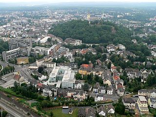
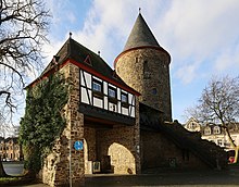
Siegburg is a city in the district of Rhein-Sieg-Kreis in North Rhine-Westphalia, Germany. It is located on the banks of the rivers Sieg and Agger, 10 kilometres (6.2 mi) from the former seat of West German government Bonn and 26 kilometres (16 mi) from Cologne. The population of the city was 39,192 in the 2013 census.

<span class="mw-page-title-main">Hürth</span> Town in North Rhine-Westphalia, Germany

Hürth is a town in the Rhein-Erft-Kreis, North Rhine-Westphalia, Germany. Hürth shares borders with the city of Cologne and is about 6 km to the southwest of Cologne city centre, at the northeastern slope of the natural preserve Kottenforst-Ville. The town consists of thirteen districts, once independent villages, and is distributed over a relatively large area. The municipal area is interspersed with lakes and stretches of forest.

<span class="mw-page-title-main">Ruppichteroth</span> Town in North Rhine-Westphalia, Germany

Ruppichteroth is a municipality in the Rhein-Sieg district, in the southern part of North Rhine-Westphalia, Germany. It is located approximately 30 kilometers east of Bonn.

<span class="mw-page-title-main">Bornheim (Rheinland)</span> Town in North Rhine-Westphalia, Germany

Bornheim is a town in the Rhein-Sieg district, in North Rhine-Westphalia, Germany. It is situated on the West bank of the Rhine, approx. 10 km north-west of Bonn, 20 km south of Cologne.

<span class="mw-page-title-main">Königswinter</span> Town in North Rhine-Westphalia, Germany

Königswinter is a town and summer resort in the Rhein-Sieg district, in North Rhine-Westphalia, Germany.

<span class="mw-page-title-main">Schleiden</span> Town in North Rhine-Westphalia, Germany

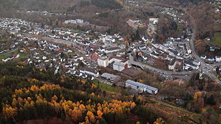
Schleiden is a town in North Rhine-Westphalia, Germany. It lies in the Eifel hills, in the district of Euskirchen, and has 12,998 inhabitants as of 30 June 2017. Schleiden is connected by a tourist railway to Kall, on the Eifel Railway between Cologne and Trier. The town consists of 18 settlements, the largest of which are Gemünd and Schleiden proper.

<span class="mw-page-title-main">Bad Honnef</span> Town in North Rhine-Westphalia, Germany

Bad Honnef is a spa town in Germany near Bonn in the Rhein-Sieg district, North Rhine-Westphalia. It is located on the border of the neighbouring state Rhineland-Palatinate. To the north it lies on the slopes of the Drachenfels mountain, part of the Siebengebirge.

<span class="mw-page-title-main">Swisttal</span> Municipality in North Rhine-Westphalia, Germany

Swisttal is a municipality in the Rhein-Sieg district, in North Rhine-Westphalia, Germany. Swisttal received its names from a brook named Swist, which flows in the middle of the municipality.

<span class="mw-page-title-main">Meckenheim</span> Town in North Rhine-Westphalia, Germany

Meckenheim is a town in the Rhein-Sieg district, in North Rhine-Westphalia, Germany.

<span class="mw-page-title-main">Lohmar</span> Town in North Rhine-Westphalia, Germany

Lohmar is a town in the Rhein-Sieg district, in North Rhine-Westphalia, Germany.

<span class="mw-page-title-main">Niederkassel</span> Town in North Rhine-Westphalia, Germany

Niederkassel is a town in the Rhein-Sieg district, in North Rhine-Westphalia, Germany, with a population of around 37,000 people. It is situated on the right bank of the Rhine, approx. 10 km (6 mi) north-east of Bonn and 15 km (9 mi) south-east of Cologne. Niederkassel is subdivided into seven quarters : Mondorf, Rheidt, Niederkassel, Uckendorf, Stockem, Lülsdorf and Ranzel. People can walk next to the river Rhine in Lülsdorf, Niederkassel and Rheidt.

<span class="mw-page-title-main">Alfter</span> Municipality in North Rhine-Westphalia, Germany

Alfter is a municipality in the Rhein-Sieg district, in North Rhine-Westphalia, Germany. It is situated approximately 6 km west of Bonn.

<span class="mw-page-title-main">Swist</span> River in Germany

The Swist is a stream, 43.6 kilometres (27.1 mi) long, in the German Rhineland. It rises on the northern edge of the Eifel at 330 metres above sea level and empties from the right and southeast into the Rhine tributary, the Erft, between Weilerswist and Bliesheim. Occasionally the Swist is also called the Swistbach, and locals often just call it der Bach.

<span class="mw-page-title-main">Verkehrsverbund Rhein-Sieg</span>

The Verkehrsverbund Rhein-Sieg is the public transport association covering the area of the Cologne/Bonn Region, North Rhine-Westphalia, Germany.

<span class="mw-page-title-main">Roman road from Trier to Cologne</span>

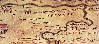
The Roman road from Trier to Cologne is part of the Via Agrippa, a Roman era long distance road network, that began at Lyon. The section from Augusta Treverorum (Trier) to the CCAA (Cologne), the capital of the Roman province of Germania Inferior, had a length of 66 Roman leagues. It is described in the Itinerarium Antonini, the itinerarium by Emperor Caracalla (198–217), which was revised in the 3rd century, and portrayed in the Tabula Peutingeriana or Peutinger Table, the Roman map of the world discovered in the 16th century, which shows the Roman road network of the 4th century.

References

  1. Wahlergebnisse in NRW Kommunalwahlen 2020, Land Nordrhein-Westfalen, accessed 29 June 2021.
  2. "Bevölkerung der Gemeinden Nordrhein-Westfalens am 31. Dezember 2021" (in German). Landesbetrieb Information und Technik NRW . Retrieved 20 June 2022.
  3. Klaus Grewe: Aquädukte. Wasser für Roms Städte. Der große Überblick – vom Römerkanal zum Aquäduktmarmor. Regionalia Verlag, Rheinbach 2014, ISBN   978-3-95540-127-6, p. 295.
  4. Heinrich Beyer: Urkundenbuch zur Geschichte der, jetzt die Preussischen Regierungsbezirke Coblenz und Trier bildenden mittelrheinischen Territorien. Aus den Quellen herausgegeben von Heinrich Beyer. Erster Band: Von den ältesten Zeiten bis zum Jahre 1169. Hölscher, Coblenz 1860, S. 20.
  5. Wilson, Colin (1988). Witches. New York, New York: Crescent Books. pp. 84–86.
  6. civitec, Zweckverband (2015-12-14). "Stadtwappen". rheinbach.de (in German). Retrieved 2017-04-14.
  7. "Partnerschaftsstädte". rheinbach.de (in German). Rheinbach. Archived from the original on 2019-12-18. Retrieved 2021-03-15.
  8. "Rhinebeck-Rheinbach Exchange Program".