Related Research Articles
Montezuma National Wildlife Refuge is a wildlife preserve operated by the United States Fish and Wildlife Service, encompassing part of the Montezuma Swamp at the north end of Cayuga Lake. The 10,004-acre (40.48 km2) preserve is composed of swamps, pools and channels and is a stopping point for migratory birds. It is the largest contiguous wetland complex in the northeastern United States and comprises a portion of the larger Montezuma Wetlands Complex, which is a partnership between the USFWS, the New York State Department of Environmental Conservation, as well as several other non-profit support organizations.

John Lester Hubbard Chafee was an American politician and officer in the United States Marine Corps. A member of the Republican Party, he served as the 66th Governor of Rhode Island, as the Secretary of the Navy, and as a United States Senator.

Don Edwards San Francisco Bay National Wildlife Refuge (DESFBNWR) is a United States National Wildlife Refuge located in the southern part of San Francisco Bay, California. Its headquarters and visitor center are in the Baylands district of Fremont, next to Coyote Hills Regional Park, in Alameda County. The visitor center is on Marshlands Rd, off Thornton Ave.

The Pinckney Island National Wildlife Refuge is a 4,053-acre (16 km2) National Wildlife Refuge located in Beaufort County, South Carolina between the mainland and Hilton Head Island. Named after Major General Charles Cotesworth Pinckney, it was established to provide a nature and forest preserve for aesthetic and conservation purposes.

The Seney National Wildlife Refuge is a managed wetland in Schoolcraft County in the U.S. state of Michigan. It has an area of 95,212 acres (385 km2). It is bordered by M-28 and M-77. The nearest town of any size is Seney, Michigan. The refuge contains the Seney Wilderness Area and the Strangmoor Bog National Natural Landmark within its boundaries.
Seal Beach National Wildlife Refuge is a wildlife refuge encompassing 965 acres (3.91 km2) located in the California coastal community of Seal Beach. Although it is located in Orange County it is included as part of the San Diego National Wildlife Refuge Complex. It was established in 1972.

The Nomans Land Island Wildlife Refuge is a United States National Wildlife Refuge located on Nomans Land, a 640-acre (2.6 km2) island off the coast of Martha's Vineyard in Massachusetts. It is part of the town of Chilmark, in Dukes County. The Island is 1.6 miles (2.6 km) long east to west, and about 1 mile (1.6 km) north to south. Nomans Land Island was used for aerial gunnery by the U.S. Navy from 1942 to 1996. The United States Fish and Wildlife Service has managed an "overlay" refuge on the Eastern third of the Island under a Joint Management Agreement between the Department of the Interior and Department of the Navy since 1975. Following an extensive surface clearance of ordnance in 1997 and 1998, the Island was transferred to the United States Fish and Wildlife Service to become Nomans Land Island National Wildlife Refuge. It was established ". .. for use as an inviolate sanctuary, or for any other management purpose, for migratory birds" under the Migratory Bird Conservation Act.
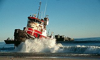
The North Cape oil spill took place on January 19, 1996, when the tank barge North Cape and the tug Scandia grounded on Moonstone Beach in South Kingstown, Rhode Island, after the tug caught fire in its engine room during a winter storm. An estimated 828,000 US gallons (3,130 m3) of home heating oil was spilled. Oil spread throughout a large area of Block Island Sound, including Trustom Pond National Wildlife Refuge, resulting in the closure of a 250-square-mile (650 km2) area of the sound for fishing.

Trustom Pond is a closed lagoon in South Kingstown, Washington County, Rhode Island, United States. It is one of nine coastal lagoons in southern Rhode Island. It has a surface area of 800 acres (320 ha), and is the only undeveloped salt pond in the state. The pond averages 1.3 feet (0.40 m) deep, and has a salinity level of 5 parts per thousand. It is non-tidal, except when breached by storms. The water directly receives about 219,844,022 US gallons (832,200 m3) of precipitation per year, with an estimated 796,215 US gallons (3,014 m3) in daily groundwater flow. No streams flow into the pond, though a nearby stream "captures water that otherwise would have flowed to Trustom Pond".
Cards Pond, or Card Pond, is a coastal lagoon in South Kingstown, Washington County, Rhode Island, United States.

Ninigret is a coastal lagoon in Charlestown, Rhode Island, in the United States, located at 41°22′45″N71°38′43″W. It is the largest of the nine lagoons, or "salt ponds", in southern Rhode Island. It is utilized for recreational activities, as well as oyster and quahog harvesting. Found along its shores are "extensive" archaeological remains. Ninigret Pond, like others in the region, was "formed after the recession of the glaciers 12,000 years ago". The pond is situated on low-lying ground, and as such, it is considered particularly vulnerable to storm surge flooding. It is connected to Green Hill Pond via a small channel.

The Ninigret National Wildlife Refuge is a National Wildlife Refuge situated along the shore of Ninigret Pond. It is characterized by salt marshes, kettle ponds, freshwater wetlands, maritime shrub lands, and forests, and it is seasonally inhabited by over 250 species of birds. The area was originally used for farming, prior to being utilized in World War II as a Naval Auxiliary landing field. It was designated as a refuge in 1970 upon the transfer of 27.5 acres (11.1 ha) of land to the U.S. Fish and Wildlife Service. Subsequent transfers and purchases increased the protected area to approximately 900 acres (360 ha). During the winter months, black ducks, Canada geese, and diving ducks are especially prominent on the pond, while various species of migrating raptors are also common. Wildlife refuge staff also maintain a piping plover nesting program.
Maine Coastal Islands National Wildlife Refuge contains more than 50 offshore islands and four coastal parcels, totaling more than 8,100 acres. The complex spans more than 250 miles (400 km) of Maine coastline and includes five national wildlife refuges—Petit Manan, Cross Island, Franklin Island, Seal Island, and Pond Island. The U.S. Fish and Wildlife Service manages the refuge complex as part of the National Wildlife Refuge System.
Located approximately 12 miles (19 km) offshore on picturesque Block Island, the Block Island National Wildlife Refuge provides crucial habitat for wildlife, and a place for people to appreciate the natural environment of the island. The refuge was established in 1973 with the transfer of 28 acres (110,000 m2) from the U.S. Coast Guard, and has grown to its current size of 127 acres (0.51 km2) today.
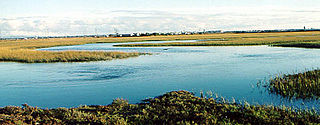
The John H. Chafee National Wildlife Refuge is a national wildlife refuge of the United States, located along the Narrow River on the southern coast of Rhode Island.

Sachuest Point is a wildlife refuge in the southeasternmost part of the Town of Middletown, Rhode Island, on a peninsula between the Sakonnet River and Rhode Island Sound, the 242-acre (0.98 km2). It is visited by over 65,000 annual people each year.

Washington County, known locally as South County, is a county located in the U.S. state of Rhode Island. As of the 2020 census, the population was 129,839. Rhode Island counties have no governmental functions other than as court administrative boundaries, which are part of the state government.

Norman Bird Sanctuary is a 325-acre (1.32 km2) bird sanctuary, nature preserve, environmental education center, and museum at 583 Third Beach Road in Middletown, Rhode Island overlooking the Atlantic Ocean.
Sandy Point Island is a 35-acre (14 ha) island in Little Narragansett Bay, lying mostly in Westerly, Rhode Island and partly in Stonington, Connecticut. Once an extension of Napatree Point, Sandy Point is now a one-mile-long (1.6 km) island that serves as an important nature preserve and recreation site. Sandy Point is the westernmost piece of land in the state of Rhode Island.
East Beach or East State Beach is a seaside public recreation area on Quonochontaug Neck, the narrow barrier island that separates Block Island Sound and Ninigret Pond, in the town of Charlestown, Rhode Island, United States. The state beach encompasses three miles (4.8 km) of oceanfront and abuts Ninigret National Wildlife Refuge.
References
![]() This article incorporates public domain material from websites or documents of the United States Fish and Wildlife Service .
This article incorporates public domain material from websites or documents of the United States Fish and Wildlife Service .
| International | |
|---|---|
| National | |