Rhode Island Route 126

Last updated

Rhode Island 126.svg

Route 126
Route information
Maintained by RIDOT
Length 14.3 mi [1] (23.0 km)
Existed May 1962 [2] – present
Major junctions
South endUS 1.svg US 1 in Providence
 

I-95.svg I95 in Providence
Rhode Island 116.svg Route 116 in Lincoln

Rhode Island 114.svg Route 114 in Woonsocket
North endMA Route 126.svg Route 126 in Blackstone, MA
Location
Counties Providence
Highway system

Rhode Island Routes

Rhode Island 123.svg Route 123 Route 128 Rhode Island 128.svg

Route 126 is a state highway running for 14.3 miles (23.0 km) in the U.S. state of Rhode Island. Route 126 is a heavily traveled route in Pawtucket.

U.S. state constituent political entity of the United States

In the United States, a state is a constituent political entity, of which there are currently 50. Bound together in a political union, each state holds governmental jurisdiction over a separate and defined geographic territory and shares its sovereignty with the federal government. Due to this shared sovereignty, Americans are citizens both of the federal republic and of the state in which they reside. State citizenship and residency are flexible, and no government approval is required to move between states, except for persons restricted by certain types of court orders. Four states use the term commonwealth rather than state in their full official names.

Rhode Island State of the United States of America

Rhode Island, officially the State of Rhode Island and Providence Plantations, is a state in the New England region of the United States. It is the smallest state in area, the seventh least populous, the second most densely populated, and it has the longest official name of any state. Rhode Island is bordered by Connecticut to the west, Massachusetts to the north and east, and the Atlantic Ocean to the south via Rhode Island Sound and Block Island Sound. It also shares a small maritime border with New York. Providence is the state capital and most populous city in Rhode Island.

Pawtucket, Rhode Island City in Rhode Island, United States

Pawtucket is a city in Providence County, Rhode Island, United States. The population was 71,148 at the 2010 census. It is the fourth largest city in the state.

Contents

Route description

Route 126 begins at an intersection with Providence's Main Street, which is carried by US 1 and Route 122. The northbound direction begins on Smithfield Avenue, and the southbound begins at Frost Street, turning towards Smithfield via Nashua Street. Once the two meet, they travel the four-lane, divided Smithfield Avenue, very soon after interchanging with Interstate 95 and coming to an intersection with Silver Spring Road and Foch Avenue, where Route 126 turns right, continuing on Smithfield Avenue. The route forms a skewed intersection with Power Road, afterwards narrowing to two lanes, and continues through a dense residential area as it skirts the west side of Pawtucket.

Providence, Rhode Island Capital of Rhode Island

Providence is the capital and most populous city of the U.S. state of Rhode Island and is one of the oldest cities in the United States. It was founded in 1636 by Roger Williams, a Reformed Baptist theologian and religious exile from the Massachusetts Bay Colony. He named the area in honor of "God's merciful Providence" which he believed was responsible for revealing such a haven for him and his followers. The city is situated at the mouth of the Providence River at the head of Narragansett Bay.

U.S. Route 1 in Rhode Island highway in Rhode Island

U.S. Route 1 in Rhode Island is a major north–south state highway through the U.S. state, specifically within the Providence metropolitan area. Staying close to the Atlantic Ocean and Narragansett Bay, it is a longer route than Interstate 95, and many portions are a four-lane divided highway.

Route 122 is a numbered State Highway running 14.2 miles (22.9 km) in Rhode Island, United States.

West of Lincoln Woods State Park and within the Lincoln town limits, Route 126 turns onto River Road, just south of Route 123, which it intersects shortly after. It continues north, now known as River Road as it parallels the Blackstone River, which lies to the east. South of Albion, the route's name changes to Old River Road at an intersection with Lower River Road, and it intersects Route 116 and flies over Interstate 295 with no access. The route then enters Manville, where it curves westward before turning right at an intersection with Sayles Hill Road, continuing north.

Lincoln Woods State Park

Lincoln Woods State Park is a public recreation area covering 627 acres (254 ha) around Olney Pond four miles (6.4 km) northwest of Pawtucket in the town of Lincoln, Rhode Island. The state park is known for its giant glacial boulders and the stony nature of its terrain which prevented most of the parkland from being used as farmland or for other development.

Lincoln, Rhode Island Town in Rhode Island, United States

Lincoln is a town in Providence County, Rhode Island, United States. The population was 21,105 at the 2010 census. Lincoln is located in northeastern Rhode Island, north of Providence. Lincoln is part of the Providence metropolitan statistical area and the Greater Boston combined statistical area.

Route 123 is a state highway running 7.7 miles (12.4 km) in the U.S. state of Rhode Island.

Passing underneath Route 99 with no access, Route 126 meets New River Road's northern terminus, upon which the route's name changes again to Manville Road, cutting briefly across the North Smithfield town line. As it enters Woonsocket, the road begins to parallel Blackstone River more closely, the two straddling a railroad alignment. Within the city, the route turns eastward onto Hamlet Avenue, forming a concurrency with its Route 122. The two routes then bridge the river and intersect Cumberland Street. Here, Route 126 turns northward onto four lanes of Cumberland Street while Route 122 turns southward. Eventually, Cumberland Street intersects Clinton Street and Social Street, where Route 126 turns eastward, using both streets for northbound and southbound, respectively.

Rhode Island Route 99 highway in Rhode Island

Route 99, also known as the Woonsocket Industrial Highway, is a numbered state highway running 2.9 miles (4.7 km) in Providence County, Rhode Island, United States. The route is a nominally north–south limited-access freeway for its entire length. Route 99 serves Manville and the Highland Industrial Park, providing freeway access to the city of Woonsocket from Rhode Island Route 146, which bypasses the city. The southern terminus of Route 99 is at a partial interchange with Route 146 in Lincoln. The freeway has one interchange in Manville, a village in Lincoln, before terminating at an at-grade intersection with Rhode Island Route 122 in Woonsocket.

North Smithfield, Rhode Island Town in Rhode Island, United States

North Smithfield is a town in Providence County, Rhode Island, United States, settled as a farming community in 1666 and incorporated into its present form in 1871. North Smithfield includes the historic villages of Forestdale, Primrose, Waterford, Branch Village, Union Village, Park Square, and Slatersville. The population was 12,314 at the 2015 census.

Woonsocket, Rhode Island City in Rhode Island, United States

Woonsocket is a city in Providence County, Rhode Island, United States. The population was 41,186 at the 2010 census, making it the sixth largest city in the state. Woonsocket lies directly south of the Massachusetts state line and constitutes part of both the Providence metropolitan area and the larger Greater Boston Combined Statistical Area.

Route 126's one-way pair merge into Social Street at an intersection with Elm Street shortly afterward. The route then intersects Privilege Street, carrying Route 114. Route 126 forms an overlap with Route 114, which it then releases at Diamond Hill Road. Route 126 continues its final trek north to the Massachusetts state line, where the route continues as Massachusetts Route 126 and still carrying the name Social Street for a short distance into that state.

Route 114 is a numbered State Highway 45.7 miles (73.5 km) long in the U.S. state of Rhode Island. It connects the city of Newport to the city of Woonsocket. Route 114 was a major north–south artery for its entire length until the arrival of the Interstate Highway System. It is still a major commercial corridor on Aquidneck Island and in northern Rhode Island.

Massachusetts State of the United States of America

Massachusetts, officially the Commonwealth of Massachusetts, is the most populous state in the New England region of the northeastern United States. It borders on the Atlantic Ocean to the east, the states of Connecticut and Rhode Island to the south, New Hampshire and Vermont to the north, and New York to the west. The state is named after the Massachusett tribe, which once inhabited the east side of the area, and is one of the original thirteen states. The capital of Massachusetts is Boston, which is also the most populous city in New England. Over 80% of Massachusetts's population lives in the Greater Boston metropolitan area, a region influential upon American history, academia, and industry. Originally dependent on agriculture, fishing and trade, Massachusetts was transformed into a manufacturing center during the Industrial Revolution. During the 20th century, Massachusetts's economy shifted from manufacturing to services. Modern Massachusetts is a global leader in biotechnology, engineering, higher education, finance, and maritime trade.

Massachusetts Route 126 highway in Massachusetts

Route 126 is a north–south state highway in Massachusetts.

History

Prior to May 1962, Route 126 was in the Tiverton and Little Compton area. It started at the intersection of present-day Route 179 and Route 81. It went north along Route 179 to present-day Route 77. It then went north on Route 77 to end at Route 138 near the eastern end of the now demolished Stone Bridge. [2]

Tiverton, Rhode Island Town in Rhode Island, United States

Tiverton is a town in Newport County, Rhode Island, United States. The population was 15,780 at the 2010 census.

Little Compton, Rhode Island Town in Rhode Island, United States

Little Compton is a town in Newport County, Rhode Island between the Sakonnet River and the Massachusetts state border. It is the birthplace of the Rhode Island Red hen.

Stone Bridge (Rhode Island) bridge in United States of America

The Stone Bridge was a bridge built in 1907 in Rhode Island that carried RI 138 over the Sakonnet River between Portsmouth and Tiverton. It was severely damaged by Hurricane Carol in 1954, and replaced in 1956 by the Sakonnet River Bridge, which was under construction at the time of the hurricane, located 0.8 mi (1.3 km) to the north. The span was closed to marine traffic after the hurricane. After inspection, it was decided to close the bridge to bus and truck traffic on January 13, 1955. It was then closed to all vehicles on January 18, 1955. Pedestrians were allowed to walk across. Repairs were made and the bridge reopened to all traffic on March 3, 1955. It remained in service until the opening of the Sakonnet River Bridge in 1956.

Major intersections

The entire route is in Providence County.

Locationmi [1] kmDestinationsNotes
Providence 0.00.0US 1.svg US 1 (North Main Street)Southern terminus of Route 126
0.30.48I-95.svg I95  Pawtucket, Downtown Providence Exit 25 on I-95
Pawtucket 1.62.6Rhode Island 15.svgUS 44.svg Route 15 (Mineral Spring Avenue) to US 44
Lincoln 3.86.1Rhode Island 123.svg Route 123 (Front Street)Southbound junction, end of SB concurrency with RI-123. Northbound uses River Rd.
4.06.4Rhode Island 123.svg Route 123 (Front Street)Beginning of southbound conucrrency with RI-123, Northbound junction.
7.111.4Rhode Island 116.svgRhode Island 146.svgI-295.svg Route 116 (George Washington Highway) to Route 146 / I295
Manville 9.615.4 Rhode Island 120.svg Main Street to Route 120
10.016.1 Rhode Island 99.svg Sayles Hill Road to Route 99
Woonsocket 12.820.6Rhode Island 122.svg Route 122 south (Hamlet Avenue)Southern terminus of concurrency with Route 122
13.020.9Bridge over the Blackstone River
13.020.9Rhode Island 122.svg Route 122 north (Cumberland Hill Road)Northern terminus of concurrency with Route 122
13.922.4Rhode Island 114.svg Route 114 north (Privilege Street)Southern terminus of concurrency with Route 114
14.022.5Rhode Island 114.svg Route 114 south (Diamond Hill Road)Northern terminus of concurrency with Route 114
14.323.0MA Route 126.svg Route 126 north Bellingham Continuation into Massachusetts
1.000 mi = 1.609 km; 1.000 km = 0.621 mi

Related Research Articles

Blackstone River river in Massachusetts and Rhode Island, USA

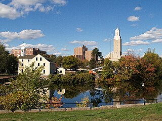
The Blackstone River is a river in the U.S. states of Massachusetts and Rhode Island. It flows approximately 48 mi (80 km) and drains a watershed of approximately 540 sq. mi (1,400 km²). Its long history of industrial use has left a legacy of pollution, and it was characterized by the United States Environmental Protection Agency in 1990 as "the most polluted river in the country with respect to toxic sediments."

U.S. Route 258 highway in the United States

U.S. Route 258 is a spur of US 58 in the U.S. states of North Carolina and Virginia. The U.S. Highway runs 220.15 miles (354.30 km) from US 17 Business and NC 24 Business in Jacksonville, North Carolina north to Virginia State Route 143 at Fort Monroe in Hampton, Virginia. In North Carolina, US 258 connects Jacksonville with the Inner Banks communities of Kinston, Snow Hill, Farmville, Tarboro, and Murfreesboro. The U.S. Highway continues through the Virginia city of Franklin, where the highway intersects US 58, and the town of Smithfield on its way to the Hampton Roads metropolitan area. US 258 crosses the James River on the James River Bridge and follows Mercury Boulevard through Newport News and Hampton.

Illinois Route 50 (IL 50) is a north–south state road in northeastern Illinois. It runs from the junction with U.S. Route 45 (US 45) in West Kankakee north to U.S. Route 41 in Skokie. This is a distance of 66.49 miles (107.01 km). In Chicago and the suburbs it's known as Cicero Avenue. Before this, Cicero Avenue was previously known as 48th Avenue, owing to its City of Chicago address of 4800 West.

Rhode Island Route 7 highway in Rhode Island

Route 7 is a numbered state highway in Rhode Island, United States. It runs approximately 16 miles (26 km) from Route 246 in Providence to Joslin Road in Burrillville.

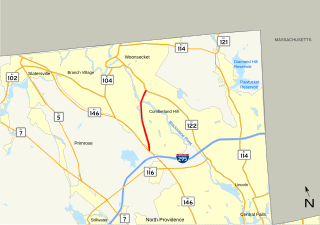
Route 104 is a numbered State Highway running 13.4 miles (21.6 km) in Rhode Island. It runs from US 44 in North Providence to Worrall Street in Downtown Woonsocket. The route connects the cities of Providence and Woonsocket via the town center of Smithfield.

Route 108 is a 8.6-mile (13.8 km) long state highway in Washington County, Rhode Island. The route begins at an intersection with Ocean Road in the village of Narragansett Pier, just north of Point Judith Light. The route's northern terminus is at an intersection with Route 138 in the town of South Kingstown, just east of the University of Rhode Island. In between, Route 108 connects to the Block Island Sound community of Galilee and passes through the villages of Wakefield and Peace Dale.

Rhode Island Route 146 highway in Rhode Island

Route 146, also known as the Louisquisset Pike, the Eddie Dowling Highway, and the North Smithfield Expressway, is a 16.24-mile (26.14 km) long numbered state highway located in Providence County, Rhode Island, United States. The route is a major north–south freeway in the northern Providence metropolitan area, directly linking Providence with the cities of Woonsocket, Rhode Island and Worcester, Massachusetts. For most of its length, Route 146 is a freeway, although there are at-grade crossings and driveway access in the North Smithfield/Lincoln area. The southern terminus of the freeway is at Interstate 95 in downtown Providence, and the route's northern terminus is at the Rhode Island-Massachusetts state line in Millville, where it continues northward towards the Massachusetts Turnpike and the city of Worcester as Massachusetts Route 146.

Route 246 is a numbered state highway running 8 miles (13 km) in Rhode Island.

Virginia State Route 2 highway in Virginia

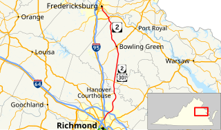
State Route 2, formerly State Route 50, is a primary state highway in the U.S. state of Virginia. The state highway runs 53.08 miles (85.42 km) from U.S. Route 1 and US 301 in Richmond north to US 1 Business, US 17 Business, and SR 3 Business in Fredericksburg. SR 2 connects Richmond and Fredericksburg via Bowling Green. The state highway runs concurrently with US 301 from Richmond to Bowling Green and with US 17 Business in the Fredericksburg area.

County Route 577 (New Jersey) highway in New Jersey

County Route 577, abbreviated CR 577, is a county highway in the U.S. state of New Jersey. The highway extends 9.96 miles (16.03 km) from Springfield Avenue in Springfield Township to Bloomfield Avenue in Verona.

County Route 511 (New Jersey) highway in New Jersey

County Route 511, abbreviated CR 511, is a county highway in the U.S. state of New Jersey. The highway extends 37.44 miles from Columbia Avenue in Morris Township to the New York state line in West Milford.

Pennsylvania Route 74 highway in Pennsylvania

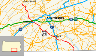
Pennsylvania Route 74 is a 96.4-mile-long (155.1 km) north–south state highway located in central Pennsylvania. The southern terminus of the route is at the Mason–Dixon line southwest of Delta, where PA 74 continues into Maryland as Maryland Route 165. The northern terminus is at Pennsylvania Route 75 south of Port Royal.

U.S. Route 221 in Virginia highway in Virginia

U.S. Route 221 is a part of the U.S. Highway System that runs from Perry, Florida to Lynchburg, Virginia. In Virginia, the U.S. Highway runs 149.61 miles (240.77 km) from the North Carolina state line near Independence north to its northern terminus at US 29 Business, US 460 Business, and US 501 Business in Lynchburg. US 221 connects Independence, Galax, and Hillsville in Southwest Virginia while running concurrently with US 58. The U.S. Highway connects those communities with Roanoke via Floyd County, within which US 221 is the main east–west highway. The U.S. Highway also runs concurrently with US 460 from Roanoke to Bedford and parallels that U.S. Highway from Bedford to Lynchburg.

Virginia State Route 116 highway in Virginia

State Route 116 is a primary state highway in the U.S. state of Virginia. The state highway runs 20.66 miles (33.25 km) from SR 122 at Burnt Chimney north to SR 101 in Roanoke. SR 116 connects northwestern Franklin County with the southeastern part of Roanoke. The state highway forms a major street through Downtown Roanoke and the city's north side.

Virginia State Route 166 highway in Virginia

State Route 166 is a primary state highway in the U.S. state of Virginia. The state highway runs 15.47 miles (24.90 km) from U.S. Route 17 in Chesapeake north to US 60 in Virginia Beach.

Maryland Route 140 highway in Maryland

Maryland Route 140 is a 49-mile (79 km) state highway in the U.S. state of Maryland.

References

  1. 1 2 Google (December 30, 2013). "Route 126" (Map). Google Maps . Google. Retrieved December 30, 2013.
  2. 1 2 "County Route Numbers Changed". The Newport Daily News. May 25, 1962. p. 2. Retrieved June 19, 2018 via Newspapers.com. Open Access logo PLoS transparent.svg

Route map: Google

KML file (edithelp)
KML is from Wikidata