The College Hill Historic District is located in the College Hill neighborhood of Providence, Rhode Island. It was designated a National Historic Landmark District on December 30, 1970. The College Hill local historic district, established in 1960, partially overlaps the national landmark district. Properties within the local historic district are regulated by the city's historic district zoning ordinance, and cannot be altered without approval from the Providence Historic District Commission.

The Smith Hill Historic District is a historic district located in northwestern Providence, Rhode Island, just west of the Rhode Island State House and Interstate 95. It includes 57-65 Brownell Street, 73-114 Holden Street, 23-80 Jewett Street, 189-240 Smith Street and 10-18 W. Park Street. This area is a densely built residential section, an isolated remnant of what was once a larger residential area. Most of the 41 properties are residential units built between 1870 and 1930, and are typically 2-1/2 or 3+1⁄2 stories in height. They are set on lot sizes ranging generally from 3000 to 5000 square feet, and are set close to the sidewalk. The only major non-residential buildings are St. Patrick's School at 244 Smith Street and "The Mohican" at 185-189 Smith Street; the latter is an Art Deco brick and concrete commercial block two stories in height.

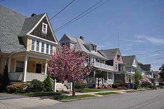
The Norwood Avenue Historic District is a residential historic district in Cranston and Providence, Rhode Island. It includes all the properties along Norwood Avenue between Broad Street in Cranston and Green Boulevard in Providence. It is lined with houses built mostly between 1890 and 1930 in the Queen Anne and Colonial Revival styles.

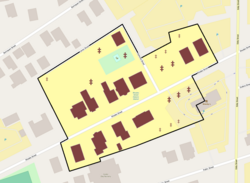
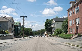
The South Central Falls Historic District is a historic district in Central Falls, Rhode Island. It is a predominantly residential area, densely populated, which was developed most heavily in the late 19th century. It is bounded roughly by Broad Street to the east, the Pawtucket city line to the south, Dexter Street to the west, and Rand Street and Jenks Park to the north. It has 377 contributing buildings, most of which were built before 1920. The district was added to the National Register of Historic Places in 1991.
The Doyle Avenue Historic District is a predominantly residential historic district on the East Side of Providence, Rhode Island. It extends along Doyle Avenue from North Main Street in the west to Proctor Place. This area was developed residentially between 1860 and 1920, with an architecturally diverse collection of houses, generally set on small lots with only modest setback from the sidewalk. Land on the south side of Doyle Avenue was owned by the Dexter Commission, which managed a large tract of land bequested to the city by Ebenezer Dexter. This land was originally leased to developers. One of the first houses built in this area was the c. 1875 Thomas Collins House at 33 Doyle Avenue, a 2-1/2 story Italianate duplex.

The Elmgrove Gardens Historic District is a residential historic district in northeastern Providence, Rhode Island, United States. It is bounded on the north by Rochambeau Street, on the south by Woodbury Street, on the east by Cole Street, and on the west by Morris Avenue. This area was developed most heavily between 1908 and 1948, and is a well-preserved example of an early automotive suburban residential area. Most of the houses in the district are either 1-1/2 or 2-1/2 stories in height, and are built in an architecturally diverse variety of styles. The district also includes to 18th-century farmhouses, reminders of the area's agrarian past.

The Freeman Plat Historic District is a residential historic district on the East Side of Providence, Rhode Island. The district is a well-preserved example of an early-20th-century planned residential area, encompassing some 50 acres (20 ha). It is roughly bounded by Sessions Street, Morris Avenue, Laurel Avenue, and Wayland Avenue, and consists of a network of generously-landscaped winding roads, laid out in consultation with the Olmsted Brothers design firm. The houses built are generally of high quality, many of them architect-designed, with architecturally diverse revival styles popular at the time. The area was developed between 1916 and 1929 by John Freeman, who owned a country estate in the area, and sought a way to develop the largely swampy tract.

Grace Church is an historic Episcopal church at 300 Westminster Street at Mathewson Street in downtown Providence, Rhode Island. It was built in 1845-46 and was designed by Richard Upjohn in the Gothic Revival style.
Moshassuck Square is an industrial historic district in Providence, Rhode Island, lining the banks of the Blackstone Canal just north of the Rhode Island State House. It consists of the few surviving buildings of the once-extensive American Screw Company complex, which was largely developed between the 1840s and 1870s, and was a major fixture in the Providence landscape prior to its destruction by fire in 1971. The buildings are in an area bounded by Charles Street on the west, Stevens and Hewes Streets on the north, North Main Street to the east, and Mill Street to the south. Prominent among them are the Stillman White Foundry and Fletcher Manufacturing Company office building, which stand on opposite sides of Mill Street near its crossing of the canal. At 127 Charles Street stands a three-story brick building built c. 1900 as a retail and residential building. The only surviving elements of the Screw Company complex are located at North Main and Hewes Streets, and now house the Providence Center.

The Oakland Avenue Historic District is a residential historic district in the Smith Hill neighborhood of Providence, Rhode Island, USA. The area is a densely built stretch of Oakland and Pembroke Avenues, extending from Eaton Street in the north to about half-way between Chad Brown Street and Smith Street in the south. Only buildings on the east side of Pembroke are included, while both sides of Oakland Avenue are, as are a few properties on adjacent roads. All but two of the 110 buildings in the district are residential, and are set on small lots of similar size. The houses are almost all multi-unit, housing either two or three units, and were built in between 1890 and 1930. The district represents a dense and well-preserved collection of this type of housing in the city, and was one of its last "inner city" areas to be developed.

The Parkis–Comstock Historic District is a residential historic district in the Elmwood neighborhood of Providence, Rhode Island. It includes all of the properties on Parkis Avenue and a number of properties on the western end of Comstock Street and Harvard Avenue, just across Broad Street from Parkis. The houses are set on relatively uniform large lots, generally set close to the street, and represent a fine collection of Late Victorian upper-class housing. Most of the houses were built between the 1860s and the 1910s. The first house to be built on Parkis Avenue was the c. 1869 Louis Comstock House at number 47; it has fine Second Empire styling, with corner quoining and a bracketed mansard roof.

The Providence Jewelry Manufacturing Historic District is a predominantly industrial historic district in Providence, Rhode Island. It covers a roughly 19-acre (7.7 ha) area in the city's Jewelry District, just south of Downtown Providence. While the area began as a residential neighborhood, it emerged in the late 19th and early 20th centuries as a center of Providence's jewelry manufacturing businesses. The oldest industrial building in the district is the 1848 Elm Street Machine Shop, a 2+1⁄2-story stone structure that now houses offices of Brown University.
The Stimson Avenue Historic District is a residential historic district on the east side of Providence, Rhode Island. It includes all of Stimson Avenue and Diman Place, as well as adjacent properties on Angell Street on the south and Hope Street on the west, forming a relatively compact rectangular area. This area was developed roughly between 1880 and 1900, and features a collection of high-quality Queen Anne and Colonial Revival houses, with a few earlier Italianate houses at its edges. Among the finest is 19 Stimson Avenue, built in 1890 to a design by Stone, Carpenter & Willson; it is stylistically transitional between Queen Anne and Colonial Revival, featuring elaborate woodwork and a large number of exterior surface finishes, in a predominantly symmetrical Colonial Revival form. The only non-residential structure is the 1893 brick Central Congregational Church at 296 Angell Street.

The Summit Historic District is a residential historic district in northeastern Providence, Rhode Island. It is bounded on the east by Summit Avenue, the south by Rochambeau Avenue, the west by Camp Street, and the north by Memorial Road and Creston Way. It contains 155 houses, most of which were built between 1918 and 1938. The area was annexed by Providence in 1874 and platted out of farmland in 1916, and represents a typical suburban development of the period. Most of these houses are set on lots between 4,500 and 5,500 square feet in size, although there are some double lots. Single family homes predominate, with a number of two- and three-family houses present. Architecturally the houses are heterogeneous, with styles ranging from the late Queen Anne to the Colonial and Tudor Revivals. The only significant non-residential structure in the district is Temple Beth Shalom at 120 Rochambeau Avenue, which does not contribute to its significance.

The Wayland Historic District is a predominantly residential historic district on the east side of Providence, Rhode Island. It is a large area, covering about 122 acres (49 ha), bounded roughly on the north by Everett and Laurel Avenues, on the east by Blackstone Boulevard and Butler Avenue, on the west by Arlington Avenue, and on the south by Angell and South Angell Streets. This area, which was in the 19th century part of the Moses Brown farm, was platted for development in 1891, with most of the construction taking place in the early decades of the 20th century. Most of the residential properties in the district are single-family houses, typically built in revival styles popular at the time. They are set on similarly sized lots with fairly uniform setbacks, and were typically built without garages. There are a number of two-family houses, and a small number of apartment buildings, most of which are found on the arterial roads of the area. There are several religious buildings, including several churches; the most architecturally distinctive religious building is the Jewish Temple Beth El, built 1951–54.
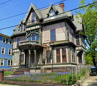
The Wesleyan Avenue Historic District is a residential historic district in the Elmwood section of Providence, Rhode Island. It includes 25 houses, on a one-block section of Wesleyan Avenue between Taylor and Broad Streets, with a few of them on the two end streets. They are large two-plus story wood-frame houses, set on modest lot, all of which were built between 1875 and 1900. The houses are in a diversity of styles popular at that time, including Second Empire, Stick style, and Queen Anne. The district includes what is one of Providence's finest Stick style houses, the Samuel Darling House at 53 Wesleyan Avenue. It was built in 1885, and displays a wealth of applied wood work, decorative shingling, and intricately carved porch details.

Wyoming is a village and census-designated place on the Wood River in southern Rhode Island, primarily in the town of Richmond, Rhode Island, but extending north across the river into the town of Hopkinton, Rhode Island. The population was 270 at the 2010 census. It is the site of the Wyoming Village Historic District and a post office assigned ZIP code 02898.

The Edgewood Historic District–Anstis Greene Estate Plat is a residential historic district in the Edgewood neighborhood of eastern Cranston, Rhode Island. The 34-acre (14 ha) area is bounded on the west by Broad Street, the east by Narragansett Bay, the south by Rosewood Avenue, and on the north by Marion Avenue, where it abuts the Edgewood Historic District-Shaw Plat. The area, originally part of a much larger property belonging to Zachariah Rhodes in the 17th century, was platted for residential development in the decades following the arrival of the streetcar on Broad Street, providing commuter service to Providence. The land was willed by Anstis Rhodes Greene to a group of heirs, who progressively developed their individual portions. The only significant surviving elements that predate this development are two small family cemeteries.

The Edgewood Historic District–Aberdeen Plat is a residential historic district in the Edgewood neighborhood of eastern Cranston, Rhode Island. Bounded by Berwick Lane and Sefton Drive to the north, Broad Street to the west, Chiswick Road to the south, and the Providence River to the east, this area was developed between 1901 and 1957 as a streetcar suburb for middle and upper middle class residents on what was once a country estate. The district was listed on the National Register of Historic Places in 2016.
The Edgewood Historic District–Sally Greene Homestead Plats is a residential historic district in the Edgewood neighborhood of eastern Cranston, Rhode Island. Bounded by Glen Avenue to the north, Broad Street to the west, Massasoit Street to the south, and the Providence River to the east, this area was developed between 1900 and 1963 as a streetcar suburb for middle and lower middle class residents on what was once a country estate. The district was listed on the National Register of Historic Places in 2016.