Richard-Wagner-Platz (Leipzig)

Last updated
Richard-Wagner-Platz
Zentrum, Leipzig, Germany - panoramio (181).jpg
The square with a fountain by Harry Müller
Location Leipzig-Mitte, Leipzig, Germany
Postal code04109
Coordinates 51°20′35.98″N12°22′20.02″E / 51.3433278°N 12.3722278°E / 51.3433278; 12.3722278

Richard-Wagner-Platz is a square in Leipzig in the northwest of Leipzig city centre within Leipzig's "ring road" on the northwest corner. The square is named after the composer Richard Wagner, whose house of birth was nearby.

Contents

New design since 2013

From April 2012 to May 2013, the 7,200 m2 (78,000 sq ft) large Richard-Wagner-Platz, which was then used as a parking lot, was redesigned after a design competition at a cost of 2.6 million euros. It was presented to the public on the eve of Wagner's 200th birthday. On the same occasion, the Leipzig Richard Wagner Memorial was unveiled about 150 m (490 ft) southwest of Richard-Wagner-Platz in the green area at Goerdelerring.

Since that redesigning [1] , the Richard-Wagner-Platz is covered by small granite paving. There are 59 young winter linden trees in a square grid 6 m (20 ft) wide, with a fountain in the middle. Some of the linden trees are surrounded by ring-shaped benches. There is a small skatepark southeast of the linden trees. The three art fountains designed by Harry Müller were set up in the open area of ​​the square. They stood on the former Sachsenplatz until 1999 and are called “dandelions” by the people of Leipzig.

History

On the site of today's Richard-Wagner-Platz, the first Slavic market (later called Eselsmarkt, which means donkey market) and the Slavic settlement of Lipsk, from which the city of Leipzig later developed, were probably formed in the 7th century. [2] This market place is older than today's Leipzig's market square. In the 10th century, the place lay at the crossing of the Via Regia coming from Merseburg and leading further to Meissen to the Via Imperii, an imperial road, later Hainstraße. At the southern end of the eastern side of the square begins the Brühl, an old street which later became the world center for fur trade practised by mostly jewish merchants. The Hainstraße ends at the corner of Brühl. South of it begins the Große Fleischergasse, which is why the square was formerly called Fleischerplatz. [3]

At the western end of the southwest side the Töpferstraße began. Until 1822 the square was bordered to the north and west by the Ranstädter Gate. It was one of the four city gates of Leipzig and formed the city exit to the west. With the demolition of the city wall, the square visually enlarged to the west. In the north, the square remained limited by the Altes Theater, also the Komödienhaus, built in 1766 on the foundations of the Ranstädter Bastei. After 1839 the square was called Theaterplatz. [4]

The Lindenau tram line (first a horse-drawn railway, later a tram) crossed the square diagonally from 22 July 1882, crossing the tracks of the Ring tram line coming from the Brühl and turning into the Ranstädter Steinweg. The line was closed on 20 July 1964. [5]

Friedrich-Engels-Platz with the pedestrian bridge in 1973. Bundesarchiv Bild 183-M0828-0009, Leipzig, Fussgangerbrucke.jpg
Friedrich-Engels-Platz with the pedestrian bridge in 1973.

On 22 May 1913, the 100th birthday of composer and conductor Richard Wagner, born in Brühl 1, Theaterplatz was renamed Richard-Wagner-Platz. Wagner's birthplace was on the corner of Brühl/Theaterplatz. It was demolished in 1886 and the Brühl department store was later built on this site.

During the Second World War, on the night of December 3-4, 1943, a British air raid destroyed many surrounding buildings, including the Altes Theater. As a result, the square visually expanded to become the Ring-Messehaus.

On 24 August 1973, a pedestrian overpass over the square to the Ring-Messehaus was opened. The 360-ton bridge had a total length of 78 m (256 ft) and connected the Dr.-Kurt-Fischer-Straße (since then Pfaffendorfer Straße) with the Brühl. At peak times, the overpass had to accommodate over 6,000 people per hour. The bridge was demolished in 2004.

The Grosser Blumenberg building. GrosserBlumbergBruhl.JPG
The Großer Blumenberg building.

The square is separated in its irregular form from the Goerdelerring and the Tröndlinring in the northwest by a narrow green area. Inside is the Hahneman Monument. The neo-classical building Großer Blumenberg borders the square to the south. The Brühl, the Hainstraße and the Große Fleischergasse border the square in the southeast.

Present age

Due to the fact that the square was regularly the venue for meetings of the Leipzig Pegida subsidiary Legida, a petition was initiated by opposing interest groups at the end of 2015 to rename the square again as "Refugees Welcome-Platz". [6] However, this initiative has not been implemented.

Related Research Articles

<span title="German-language text"><span lang="de" style="font-style: normal;">Alexanderplatz</span></span> Square in Berlin, Germany

Alexanderplatz is a large public square and transport hub in the central Mitte district of Berlin. The square is named after the Russian Tsar Alexander I, which also denotes the larger neighbourhood stretching from Mollstraße in the north-east to Spandauer Straße and the Rotes Rathaus in the south-west.

<span class="mw-page-title-main">Potsdamer Platz</span> Public square and traffic intersection in Berlin, Germany

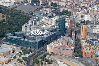
Potsdamer Platz is a public square and traffic intersection in the center of Berlin, Germany, lying about 1 km (1,100 yd) south of the Brandenburg Gate and the Reichstag, and close to the southeast corner of the Tiergarten park. It is named after the city of Potsdam, some 25 km (16 mi) to the south west, and marks the point where the old road from Potsdam passed through the city wall of Berlin at the Potsdam Gate. Initially, the open area near the city gate was used for military drills and parades. In the 19th into the 20th century, it developed from an intersection of suburban thoroughfares into the most bustling traffic intersection in Europe. The area was totally destroyed during World War II and then left desolate during the Cold War era when the Berlin Wall bisected its location. Since German reunification, Potsdamer Platz has been the site of major redevelopment projects.

<span class="mw-page-title-main">Friedrichstadt (Berlin)</span> Historic neighbourhood of Berlin, Germany

Friedrichstadt was an independent suburb of Berlin, and is now a historical neighbourhood of the city itself. The neighbourhood is named after the Prussian king Frederick I.

<span class="mw-page-title-main">Leipziger Straße</span>

Leipziger Straße is a major thoroughfare in the central Mitte district of Berlin, capital of Germany. It runs from Leipziger Platz, an octagonal square adjacent to Potsdamer Platz in the west, to Spittelmarkt in the east. Part of the Bundesstraße 1 highway, it is today one of the city's main east–west road links.

<span class="mw-page-title-main">Leipziger Verkehrsbetriebe</span> German public transport operator

The Leipziger Verkehrsbetriebe (LVB), literally translated into English as the Leipzig Transport Authority, operates the tramway and bus transport services in Leipzig, Germany. The LVB network is a part of the regional public transport association, the Mitteldeutscher Verkehrsverbund (MDV). The LVB was formed by the merger, from 1 January 1917, of two predecessor undertakings, the Großen Leipziger Straßenbahn and the Leipziger Elektrischen Straßenbahn. The merged undertaking was also known as GLSt until it was reorganized and renamed as the LVB, from 29 July 1938.

<span class="mw-page-title-main">Goerdelerring</span> Street in Leipzig, Germany

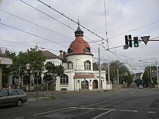
Goerdelerring is a street and major tram interchange station in Leipzig, Germany. It is named after Carl Friedrich Goerdeler.

<span class="mw-page-title-main">Leipziger Platz</span> Square in Berlin, Germany

Leipziger Platz is an octagonal square in the center of Berlin. It is located along Leipziger Straße just east of and adjacent to the Potsdamer Platz.

<span class="mw-page-title-main">Brühl (Leipzig)</span> Street in Leipzig

The Brühl is a street in the centre of Leipzig, Germany, just within the former city wall. Until the 1930s, it was the international centre of fur trade.

<span class="mw-page-title-main">Augustusplatz</span>

The Augustusplatz is a square located at the east end of the city centre of Leipzig, borough Leipzig-Mitte. It is the city's largest square and one of the largest squares in Europe. It is also part of the city's inner-city ring-road and a central hub for its tram network.

<span class="mw-page-title-main">Mitte (locality)</span> Quarter of Berlin in Germany

Mitte is a central section of Berlin, Germany, in the eponymous borough of Mitte. Until 2001, it was itself an autonomous district.

<span class="mw-page-title-main">Konstablerwache</span> Town square in Frankfurt, Germany

Konstablerwache is a central square in the centre of Frankfurt am Main and part of its pedestrian zone. It lies to the east of Hauptwache with both squares linked by the Zeil, the central shopping area of the city.

<span class="mw-page-title-main">Waldstraßenviertel</span>

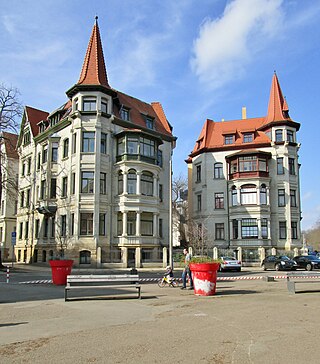
Waldstraßenviertel, is a neighbourhood in the north west of Leipzig's borough Mitte in Saxony, Germany. It is considered one of the largest complete areas of Gründerzeit buildings in Europe and is therefore considered of important cultural and heritage status. Many of its buildings are therefore protected or listed.

<span class="mw-page-title-main">Altes Theater (Leipzig)</span>

The Altes Theater was the first theatre building in the German city of Leipzig. It was on the site of today's tramway station Goerdelerring near Richard-Wagner-Platz.

<span class="mw-page-title-main">Musikalische Komödie</span> German theatre venue

The Musikalische Komödie is an operettas and musicals theatre in Leipzig. Its venue is located in the Lindenau district in the Haus Dreilinden, which is often referred to as the "Musical Comedy" itself. It is one of the three sections of the Oper Leipzig. However, it has its own ensemble with soloists, choir, ballet company and orchestra. Because of this and its own venue, it is perceived by the public as an independent cultural institution. Its repertoire ranges from Spieloper to operetta and musicals.

<span class="mw-page-title-main">Alte Messe Leipzig</span> Old fair site in Leipzig (Germany)

Alte Messe Leipzig is the circa 50 hectares site in the southeastern part of Leipzig's district Mitte, where from 1920 until 1991 the technical exhibitions of the Leipzig Trade Fair took place, as well as the buildings that stand on it – but not the trade fair itself, which found a new home at a new site in the northern part of Leipzig. Since 1996 there has been no trade fair activity on the old site.

<span class="mw-page-title-main">Inner City Ring Road (Leipzig)</span> Street in Leipzig, Germany

The Inner City Ring Road in Leipzig in the district of Mitte is the ring road around Leipzig's city centre. It encloses the just 0.7 km2 large area of the old town without the former Vorstadts.

<span class="mw-page-title-main">Leipzig-Mitte</span> Borough of Leipzig in Saxony, Germany

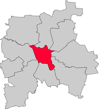
Leipzig-Mitte is one of ten boroughs (Stadtbezirke) of Leipzig, located in the center of the city. It includes numerous architectural monuments. Most of them are located in the subdivision "Zentrum", which is sited inside the Inner City Ring Road and the Promenadenring:

<span class="mw-page-title-main">Promenadenring (Leipzig)</span> Municipal landscape park in Germany

The Promenadenring Leipzig is the oldest municipal landscape park in Germany and one of the most important garden and cultural monuments in the city. The term is also used as a synonym for Leipzig's inner city ring road, a traffic facility that is connected to the green spaces of the Promenadenring. Like the inner city ring road, the promenade ring is about 3.6 kilometers long (2.24 mi.).

<span class="mw-page-title-main">Markt (Leipzig)</span> Square in Leipzig, Germany

The Markt is a square of about 1 ha in Leipzig's district of Mitte, Germany. It is considered the center of the city. The Old Town Hall stands on it, which demonstrates its particular historical importance. The square was named Platz des Friedens from 1950 to 1954. Its paving is a listed heritage monument.

<span class="mw-page-title-main">Karl-Heine-Strasse</span> Street in Leipzig, Germany

Karl-Heine-Strasse is a radial road in the west of Leipzig marking the boundary between the current boroughs of Leipzig-Plagwitz and Leipzig-Lindenau . 2.01 km (1.2 mi) long, it is named after the industrialist Karl Heine.

References

  1. "Urban lighting project "Richard-Wagner-Platz" / Beleuchtungsprojekt "Richard-Wagner-Platz" (PDF). leipzig.de (in English and German). City of Leipzig. 2014. Retrieved 2024-03-10.
  2. Winkler, Friedemann (1998). Leipzigs Anfänge. Bekanntes, Neues, offene Fragen (in German) (Leipziger Hefte, 12 ed.). Beucha: Sax-Verlag. p. 18. ISBN   3-930076-61-6.
  3. Richard-Wagner-Platz im Leipzig-Lexikon
  4. Altes Theater bei Leipziger Notenspur
  5. Leipziger Verkehrbetriebe, ed. (1996). Vom Zweispänner zur Stadtbahn. Die Geschichte der Leipziger Verkehrsbetriebe und ihrer Vorgänger (in German). Leipzig. p. 210.{{cite book}}: CS1 maint: location missing publisher (link)
  6. "Leipzigs Grüne unterstützen Initiative für "Refugees-Welcome-Platz"". LVZ - Leipziger Volkszeitung (in German). Retrieved 2020-12-28.

51°20′37″N12°22′19″E / 51.3437°N 12.3720°E / 51.3437; 12.3720