Related Research Articles

The River Stour is a river in Kent, England that flows into the North Sea at Pegwell Bay. Above Plucks Gutter, where the Little Stour joins it, the river is normally known as the Great Stour. The upper section of the river, above its confluence with the East Stour at Ashford is sometimes known as the Upper Great Stour or West Stour. In the tidal lower reaches, the artificial Stonar Cut short cuts a large loop in the natural river.

Faversham railway station is on the Chatham Main Line in England, serving the town of Faversham, Kent. It is 51 miles 77 chains (83.6 km) down the line from London Victoria. The station and all trains that call are operated by Southeastern.

The East Kent Light Railway was part of the Colonel Stephens group of cheaply built rural light railways in England. Holman Fred Stephens was engineer from its inception, subsequently becoming director and manager. The line ran from Shepherdswell to Wingham Station with a branch from Eastry through Poison Cross to Richborough Port. Built primarily for colliery traffic within the Kent Coalfields, the line was built with many spurs and branches to serve the mines, with cancelled plans to construct extensions to several others. The success of Tilmanstone colliery allowed the main line of the railway to continue operation until 1986. A remainder of the line became the East Kent Railway, a heritage railway, in 1987.

Baggrow railway station was in the former county of Cumberland, now Cumbria, England. It was a stop on the Bolton Loop of the Maryport and Carlisle Railway.

Eastry railway station was a railway station on the East Kent Light Railway. It opened on 16 October 1916 and closed to passenger traffic after the last train on 30 October 1948. It was the station before the Richborough Branch diverged from the main line to Wingham. The station served the village of Eastry, it had a passing loop, but this had been converted to a siding in 1948. The track was removed in May 1954. There is no trace of the station today as the area has been landscaped into fields.
Sandwich Road railway station was a railway station on the East Kent Light Railway. It opened in November 1925 and closed to passenger traffic on 31 October 1928. There were plans to extend to Richboro Port railway station but permission to run passenger services north of Sandwich Road was not granted by His Majesty's Railway Inspectorate due to the poor state of repair of the bridge over the Southern Railway and River Stour. The platform was north of the road and a passing loop was south of the road. The station officially closed completely on 1 January 1950 although its use may have ceased earlier.

Ampress Works Halt was a halt station on the Lymington Branch Line which, between 1956 and 1989, served the Wellworthy engineering works near Lymington in Hampshire, England. Sited near the bridge over the A337 Lymington to Brockenhurst road, the station closed when the engineering works ceased operation. The station never appeared in any public timetable.
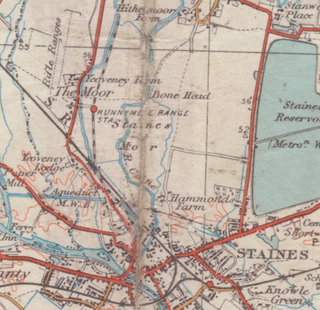
Yeoveney Halt was a railway platform of a minimalist nature on the Staines & West Drayton Railway. It was opened in June 1887 as Runnymede Range Halt on a restricted basis, gaining a regular public service from 1 March 1892. It was renamed Runymede Halt on 9 July 1934, and again renamed Yeoveney Halt on 4 November 1935, to deter tourists who came seeking the place where Magna Carta was signed. It closed on 14 May 1962, before the 1965 closure of the branch.

Shakespeare Cliff Halt is a private halt station on the South Eastern Main Line. It is located to the western end of the dual bore Shakespeare Cliff tunnel on the South Eastern Main Line to Folkestone, England. It never appeared in any public timetable and has been used successively by railway staff, coal miners, the military and Channel Tunnel workers.
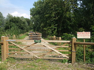
Junction Road Halt, also known as Junction Road , was a halt station on the Kent and East Sussex Railway. It was located on the eastern side of the level crossing across the B2244 Junction Road near the hamlet of Udiam in East Sussex, England. Closed for passengers in 1954 and freight in 1961 with the line, The line through Junction Road Halt may yet be revived as the Rother Valley Railway, a preservation society, is proposing to reopen the line from Robertsbridge to Bodiam.

Salehurst Halt was a halt station on the Kent and East Sussex Railway which served the village of Salehurst in East Sussex, England. The station was reached by a footpath leading south from the village church in Salehurst. Closed in 1954, Salehurst Halt may yet see trains again as the Rother Valley Railway, a preservation society, is proposing to reopen the line from Robertsbridge to Bodiam, including the line through the halt.

Wittersham Road is a railway station on the Kent and East Sussex Railway. It is located to the north-east of the level crossing on Maytham Road which links the Kentish villages of Rolvenden and Wittersham. Having served the area for over sixty years, the station closed for regular passengers in 1954 and completely in 1961. It was later rebuilt and reopened in 1977 by the Kent and East Sussex Railway heritage organisation.

Butterley railway station is a preserved railway station on the Heritage Midland Railway - Butterley in Derbyshire.
The Cranbrook and Tenterden Light Railway was a railway line which was to have linked the Hawkhurst Branch Line with the Rother Valley Railway in Kent. Although it received authorisation for its construction, only a short section of it was ever built. This section is open today as part of the Kent and East Sussex Railway.
Treloar's Hospital Platform was a railway station which served Lord Mayor Treloar's hospital in Alton, Hampshire, England.

Grimsby Pier railway station was sited on the now demolished pier with the same name in Grimsby, England.

Park Lane Halt railway station was an unadvertised halt which served the communities of Bickershaw and Abram southeast of Wigan, England.

Marron Junction railway station was a later addition to the Cockermouth and Workington Railway. It opened on 2 April 1866 with a single, eastbound, platform when the adjacent Marron Junction opened, two months before the company was absorbed by the London and North Western Railway.

Cumberland and Westmorland Convalescent Institution railway station was a terminus off the short Blitterlees Branch off the Carlisle and Silloth Bay Railway, within Silloth itself. The larger railway ran from Carlisle, England. The station does not appear on standard railway maps, but it can be discerned with a magnifying glass on at least two published maps and clearest of all on the 1914 25" OS map.
Headcorn Junction railway station was the Kent and East Sussex Railway's northern terminus. It was adjacent to the South Eastern and Chatham Railway's Headcorn station. It opened in 1905 and closed in 1954.
References
Notes
- ↑ 1938 2" to 1 mile Ordnance Survey map
- ↑ Lawson Finch & Garrett (2003a), pp. 31, 37.
- ↑ White (1987), p. 37.
- ↑ Lawson Finch & Garrett (2003a), pp. 31–32.
- ↑ Lawson Finch & Garrett (2003a), pp. 69, 107.
- ↑ Lawson Finch & Garrett (2003a), p. 80.
- 1 2 Lawson Finch & Garrett (2003a), p. 123.
- ↑ Lawson Finch & Garrett (2003a), pp. 96–97.
- 1 2 Lawson Finch & Garrett (2003a), p. 155.
- ↑ Mitchell & Smith (1989), fig. 91.
- ↑ Course (1976), p. 88.
- 1 2 Lawson Finch & Garrett (2003a), pp. 157–158.
- ↑ Mitchell & Smith (1989), fig. 95.
- 1 2 3 Lawson Finch & Garrett (2003b), p. 315.
- 1 2 Mitchell & Smith (1989), fig. 92.
- 1 2 White (1987), p. 39.
- ↑ Lawson Finch & Garrett (2003a), p. 158.
- ↑ Course (1976), p. 87.
- 1 2 Lawson Finch & Garrett (2003b), p. 332.
- 1 2 Course (1976), p. 104.
- ↑ Lawson Finch & Garrett (2003b), p. 331.
- 1 2 Lawson Finch & Garrett (2003b), p. 329.
- ↑ Croughton, Kidner & Young (1982), p. 148.
- ↑ Quick (2009), p. 330.
- ↑ Lawson Finch & Garrett (2003b), p. 243.
- 1 2 Lawson Finch & Garrett (2003b), p. 316.
- ↑ White (1987), p. 156.
- 1 2 "Disused Stations". Subterranea Britannica.
Sources
- Course, Edwin (1976). The Railways of Southern England: Independent and Light Railways. London: B.T. Batsford. ISBN 0-7134-0490-6.
- Croughton, Godfrey; Kidner, R.W.; Young, Alan (1982). Private and Untimetabled Railway Stations. Salisbury: Oakwood Press. ISBN 0-85361-281-1.
- Lawson Finch, M.; Garrett, S.R. (2003a). The East Kent Railway: The History of the Independent Railway. Vol. 1. Usk: The Oakwood Press. ISBN 0-853616-08-6.
- Lawson Finch, M.; Garrett, S.R. (2003b). The East Kent Railway: Nationalisation, the Route, Rolling Stock and Operation. Vol. 2. Usk: The Oakwood Press. ISBN 0-853616-09-4.
- Mitchell, Vic; Smith, Keith (June 1989). The East Kent Light Railway. Country Railway Routes. Midhurst, Sussex: Middleton Press. ISBN 0-906520-61-4.
- Quick, Michael (2009) [2001]. Railway passenger stations in Great Britain: a chronology (4th ed.). Oxford: Railway & Canal Historical Society. ISBN 978-0-901461-57-5. OCLC 612226077.
- White, H.P. (1987) [1976]. Forgotten Railways: South-East England. Forgotten Railways Series. Newton Abbot, Devon: David & Charles. ISBN 978-0-946537-37-2.