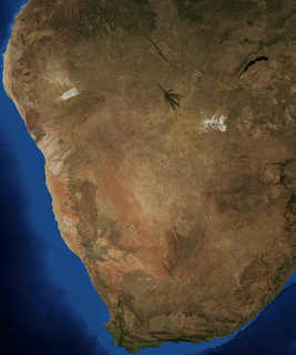
The Kalahari Desert is a large semi-arid sandy savannah in Southern Africa extending for 900,000 square kilometres (350,000 sq mi), covering much of Botswana, and parts of Namibia and South Africa.

Namibia, officially the Republic of Namibia, is a country in Southern Africa. Its western border is the Atlantic Ocean, sharing land borders with Zambia and Angola to the north, Botswana to the east and South Africa to the south and east. Although it does not border Zimbabwe, less than 200 metres of the Botswanan right bank of the Zambezi River separates the two countries. Namibia gained independence from South Africa on 21 March 1990, following the Namibian War of Independence. Its capital and largest city is Windhoek. Namibia is a member state of the United Nations (UN), the Southern African Development Community (SADC), the African Union (AU) and the Commonwealth of Nations.
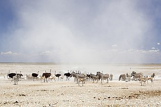
Etosha National Park is a national park in northwestern Namibia and one of the largest national parks in Africa. It was proclaimed a game reserve in March 1907 in Ordinance 88 by the Governor of German South West Africa, Friedrich von Lindequist. It was designated as Wildschutzgebiet in 1958, and was elevated to the status of a national park in 1967 by an act of parliament of the Republic of South Africa. It spans an area of 22,270 km2 (8,600 sq mi) and gets its name from the large Etosha pan which is almost entirely within the park. With an area of 4,760 km2 (1,840 sq mi), the Etosha pan covers 23% of the total area of the national park. The area is home to hundreds of species of mammals, birds and reptiles, including several threatened and endangered species such as the black rhinoceros.

Edenvale is a small city on the East Rand in Gauteng, South Africa. The greater Edenvale area has an estimated population of 70,000, including Greenstone, Harmelia, Highway Gardens, Buurendal and Croydon. Edenvale is part of the Ekurhuleni Metropolitan Municipality. It lies about halfway between the O.R. Tambo International Airport and the Johannesburg city centre and is located 12 km by road from Sandton and about 9 km from the closest Gautrain station.

Winburg is a small mixed farming town in the Free State province of South Africa.

Derby is a small town situated in North West Province of South Africa that was named after the British Secretary of State Lord Derby. Derby began as a refuge for destitute people.

The R31 is a provincial route in South Africa that connects Kimberley with the Namibian border at Rietfontein via Kuruman and Hotazel. It is co-signed with the R360 between Askham and Andriesvale.

Omuramba is the term for ancient river-beds found in the Kalahari Desert of Africa, notably in the North Eastern part of Namibia and North Western part of Botswana. The word is taken from the Herero language. An omuramba provides occasional standing pools of water and more fertility than in the surrounding sand plains. Some specific omiramba are named: Eiseb, Rietfontein, Epukiro, Omatako. They mostly start in the central parts of Namibia and run into the central parts of Botswana.

Aroab is a village with a population of approximately 5,000 in the ǁKaras Region of southern Namibia. It is situated about 170 kilometres (110 mi) south-east of Keetmanshoop on the edge of the Kalahari desert; the average annual rainfall is about 150–200 mm. Aroab is the district centre of the Keetmanshoop Rural electoral constituency.

Axel Wilhelm Eriksson was a Swedish ornithologist, settler and trader in what is now Namibia. He was born in Vänersborg, in Sweden.

Otjombinde Constituency is an electoral constituency in the Omaheke Region of Namibia. It had 6,378 inhabitants in 2004 and 4,879 registered voters in 2020. The district capital of the constituency is the settlement of Otjombinde, its main economic hub is Talismanus. The constituency forms part of the border between Namibia and Botswana, it contains the settlements of Eiseb, Helena, and Rietfontein.

Dorsland Trek is the collective name of a series of explorations undertaken by Boer settlers from South Africa from 1874 to 1881, in search of political independence and better living conditions. The participants, Trekboers from the Orange Free State and Transvaal, are called Dorslandtrekkers.

Marikana, formerly known as Rooikoppies, is a town in the Rustenburg local municipality, Bojanala Platinum District Municipality district in the North West province of South Africa.

Gert Andries Jacobus Alberts was the leader of the First Dorsland Trek. He was a member of the Gereformeerde Kerk and served as a ‘kerkraadslid’.

Bethlehem Commando was a light infantry regiment of the South African Army. It formed part of the South African Army Infantry Formation as well as the South African Territorial Reserve.

Edenvale Commando was a light infantry regiment of the South African Army. It formed part of the South African Army Infantry Formation as well as the South African Territorial Reserve.
Heilbron Commando was a light infantry regiment of the South African Army. It formed part of the South African Army Infantry Formation as well as the South African Territorial Reserve.

Vrede Commando was a light infantry regiment of the South African Army. It formed part of the South African Army Infantry Formation as well as the South African Territorial Reserve.
Kroonstad Commando was a light infantry regiment of the South African Army. It formed part of the South African Army Infantry Formation as well as the South African Territorial Reserve.


