The protected areas of South Africa include national parks and marine protected areas managed by the national government, public nature reserves managed by provincial and local governments, and private nature reserves managed by private landowners. Most protected areas are intended for the conservation of flora and fauna. National parks are maintained by South African National Parks (SANParks). A number of national parks have been incorporated in transfrontier conservation areas.

The Highveld is the portion of the South African inland plateau which has an altitude above roughly 1500 m, but below 2100 m, thus excluding the Lesotho mountain regions to the south-east of the Highveld. It is home to some of the country's most important commercial farming areas, as well as its largest concentration of metropolitan centres, especially the Gauteng conurbation, which accommodates one-third of South Africa's population.

The Colorado River Delta is the region where the Colorado River flows into the Gulf of California. The delta is part of a larger geologic region called the Salton Trough. Historically, the interaction of the river's flow and the ocean's tide created a dynamic environment, supporting freshwater, brackish, and saltwater species. Within the delta region, the river split into multiple braided channels and formed complex estuary and terrestrial ecosystems. Use of water upstream and the accompanying reduction of fresh water flow has resulted in loss of most of the wetlands of the area, as well as drastic changes to the aquatic ecosystems. However, a scheme is currently in place which aims to rejuvenate the wetlands by releasing a pulse of water down the river delta.

The Jukskei River is one of the largest rivers in Johannesburg, South Africa. It is the southernmost river in the Crocodile River (West) basin.

Hartbeespoort Dam is an arch type dam situated in the North West Province of South Africa. It lies in a valley to the south of the Magaliesberg mountain range and north of the Witwatersberg mountain range, about 35 kilometres north west of Johannesburg and 20 kilometres west of Pretoria. The name of the dam means "gorge of the hartebeest" in Afrikaans. This "poort" in the Magaliesberg was a popular spot for hunters, where they cornered and shot the hartebeest. The dam was originally designed for irrigation, which is currently its primary use, as well as for domestic and industrial use. The dam has suffered from a hypertrophic state since the early 1970s. Mismanagement of waste water treatment from urban zones within the Hartbeespoort Dam catchment area is largely to blame, having distorted the food web with over 280 tons of phosphate and nitrate deposits.

Wildlife of the Gambia is dictated by several habitat zones over its total land area of about 10,000 km2. It is bound in the south by the savanna and on the north by the Sudanian woodlands. The habitats host abundant indigenous plants and animals, in addition to migrant species and newly planted species. They vary widely and consist of the marine system, coastal zone, estuary with mangrove vegetation coupled with Banto Faros, river banks with brackish and fresh water zones, swamps covered with forests and many wetlands.

The Fogg Dam Conservation Reserve is a protected area consisting of a wetland area approximately 70 km (43 mi) east of Darwin in the Northern Territory of Australia. It lies within the Adelaide and Mary River Floodplains, which is an Important Bird Area.
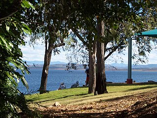
The Boyne River is a river located in Central Queensland, Australia.

The Rietvlei dam is an earth-fill type dam and is one of a number of dams supplying water to the Pretoria region of South Africa. It supplies around 41 million liters of drinking water daily, about 5.9% of the water requirement of Pretoria. The dam mainly serves for municipal and industrial use. Its hazard potential has been ranked high (3).

The Hennops River is one of the larger rivers that drains Gauteng, South Africa. It has its source near Kempton Park, eastern Johannesburg and meets the Crocodile River (Limpopo) shortly before Hartbeespoort Dam. It is one of Gauteng's most polluted rivers.
Bloemhof Dam is a dam in South Africa. It was originally known as the Oppermansdrif Dam when under construction during the late 1960s. It is located at the confluence of the Vaal River and the Vet River, on the border between the provinces North West and Free State. The dam wall has a total length of 4,270 metres (14,010 ft) The reservoir is very shallow, and therefore needs a large area to mean anything for water storage. The area around the reservoir (dam), has been a protected area, but because it lies on the border between provinces, these became two separate nature reserves. On the North West Province side lies the Bloemhof Dam Nature Reserve, on the Free State side is the Sandveld Nature Reserve.
Crocodile (West) and Marico WMA, or Crocodile (West) and Marico Water Management Area , in South Africa is sub-divided into 6 sub-management areas each corresponding with a (part) river drainage area, and include the following major rivers: the Crocodile River and Marico River, sub divided into an upper Crocodile River sub-management area and a lower Crocodile River sub-management area. The Marico River sub-management area, the upper Molopo River sub-management area, The Elands River sub-management area, and the Apies River / Pienaars River sub-management area.

The Crocodile River is a river in South Africa. After its confluence with the Marico River, both rivers form the Limpopo River.
The Pienaars River is a river in South Africa. It is a tributary of the Crocodile River. A short section of this river is known as the Moretele River. Tributaries of the Pienaars River include the Moreletaspruit. Note that the above-mentioned Moretele river section is 60 km away from the Moreletaspruit and these two should not be confused with one another.
Drainage Basin A, is one of the drainage basins of South Africa. The main river in this system is the Limpopo River. It is subdivided into 9 sub-drainage basins.
The Rietvlei Wetland Reserve is a 663-hectare (1,640-acre) nature reserve situated in Milnerton, Cape Town, South Africa. It is managed by the City of Cape Town's Environmental Resource Management Department.

The Diep River Fynbos Corridor is a nature reserve located in Cape Town, South Africa. It forms part of the larger Table Bay Nature Reserve, which was established in June 2012.

The Elands River is a river in the former Transvaal area, South Africa. It is a tributary of the Olifants River, part of the Limpopo River basin.


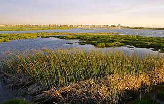
 The Rietvlei river wetlands
 Water released from the dam into Sesmylspruit
