
Pretoria is South Africa's administrative capital, serving as the seat of the executive branch of government, and as the host to all foreign embassies to South Africa.

Gauteng is one of the nine provinces of South Africa.

Midrand is a former municipality in central Gauteng, South Africa. Situated in-between Centurion and Sandton, Midrand now forms part of the City of Johannesburg Metropolitan Municipality.

Glenbawn Dam is a major ungated earth and rock fill with clay core embankment dam with concrete chute spillway plus fuse plugs across the Hunter River upstream of Aberdeen in the Hunter Valley of New South Wales, Australia. The dam's purpose includes flood mitigation, hydro-electric power, irrigation, water supply and conservation. The impounded reservoir is called Lake Glenbawn.

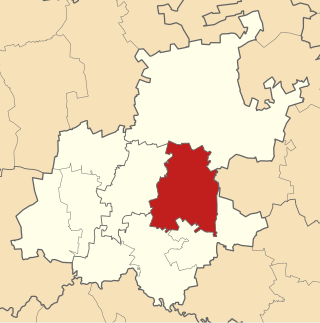
The City of Tshwane Metropolitan Municipality, also known as the City of Tshwane, is the metropolitan municipality that forms the local government of northern Gauteng in South Africa. The metropolitan area is centred on the city of Pretoria with surrounding towns and localities included in the local government area.

Kempton Park is a city in the East Rand region of Gauteng province, South Africa. It is part of the City of Ekurhuleni Metropolitan Municipality. It is situated south of Tembisa, one of the largest townships in South Africa, which is also part of Ekurhuleni. South Africa's busiest airport, O. R. Tambo International Airport is located in Kempton Park.

The Highveld is the portion of the South African inland plateau which has an altitude above roughly 1500 m, but below 2100 m, thus excluding the Lesotho mountain regions to the south-east of the Highveld. It is home to some of the country's most important commercial farming areas, as well as its largest concentration of metropolitan centres, especially the Gauteng conurbation, which accommodates one-third of South Africa's population.

The R24 is a major East-West provincial route in the Gauteng and North West provinces that links OR Tambo International Airport with Rustenburg via Johannesburg, Krugersdorp and Magaliesburg. The process of renaming the streets and freeway that form the route from Krugersdorp eastward to OR Tambo International after anti-apartheid stalwart Albertina Sisulu was completed in 2013.

The Lesotho Highlands Water Project (LHWP) is an ongoing water supply project with a hydropower component, developed in partnership between the governments of Lesotho and South Africa. It comprises a system of several large dams and tunnels throughout Lesotho and delivers water to the Vaal River System in South Africa. In Lesotho, it involves the rivers Malibamatso, Matsoku, Senqunyane, and Senqu. It is Africa's largest water transfer scheme.
The City of Ekurhuleni Metropolitan Municipality is a metropolitan municipality that forms the local government of the East Rand region of Gauteng, a large suburban region east of Johannesburg. Ekurhuleni means "place of peace" in XiTsonga. Ekurhuleni is one of the five districts of Gauteng and one of the eight metropolitan municipalities of South Africa. The seat of Ekurhuleni is Germiston and the most spoken language is Zulu at 28.6%. The city is home to South Africa's busiest airport, OR Tambo International Airport, which is in the Kempton Park area of Ekurhuleni.

The N12 is a national route in South Africa which runs from George through Beaufort West, Kimberley, Klerksdorp and Johannesburg to eMalahleni.

The Prospect Reservoir is a heritage-listed 50,200-megalitre potable water supply and storage reservoir created by the Prospect Dam, across the Prospect Creek located in the Western Sydney suburb of Prospect, in New South Wales, Australia. The eastern bounds of the reservoir are a recreational area and the western periphery are within the bounds of Western Sydney Parklands. It was added to the New South Wales State Heritage Register on 18 November 1999.
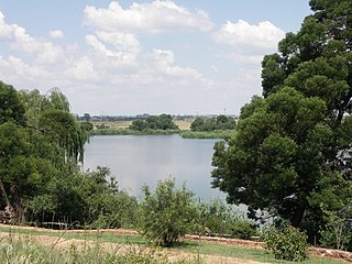
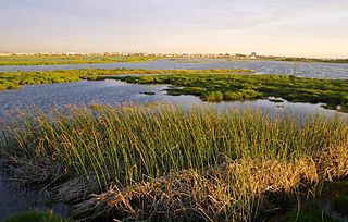
Rietvlei Nature Reserve, located in southern Pretoria, is about 4,000 hectares (40 km2) in size, and includes the entirety of the Rietvlei Dam which impounds the Rietvlei River, in Gauteng, South Africa. The reserve is wedged between the R21 highway on the western side and the R50 (Delmas-Bapsfontein) road on the north-east. The mean elevation above sea level is approximately 1,525 meters, with the highest point at 1,542 m and the lowest at 1,473 m, the dam’s outflow in Sesmylspruit. The reserve covers a surface area of approximately 4,003 ha or 40 km2, of which the dam constitutes some 20ha. A network of roads criss-cross the entire area, which facilitates access to visitors and management.
Theewaterskloof Dam is an earth-fill type dam located on the Sonderend River near Villiersdorp, Western Cape, South Africa. Administratively it is located within Theewaterskloof Local Municipality. It was established in 1978 and is the largest dam in the Western Cape Water Supply System with a capacity of 480 million cubic metres, about 41% of the water storage capacity available to Cape Town, which has a population of over 4 million people. The dam mainly serves for municipal and industrial use as well as for irrigation purposes. The hazard potential of the dam has been ranked high (3).
Voëlvlei Dam is a dam located in the Western Cape, South Africa near the town of Gouda. The earth-fill wall is 2,910 metres (9,550 ft) long and 10 metres (33 ft) high. The reservoir covers an area of 1,524 hectares and has a capacity of 168,000 megalitres, making it the second-largest reservoir in the Western Cape Water Supply System. Water from the reservoir is supplied to water treatment works of the City of Cape Town and the West Coast District Municipality, and can also be released into the Berg River for agricultural purposes or to fill the Misverstand Dam.
The Rietvlei Wetland Reserve is a 663-hectare (1,640-acre) nature reserve situated in Table View, Western Cape, South Africa. It is managed by the City of Cape Town's Environmental Resource Management Department.

The Rietvlei River is a small river in central Gauteng Province, South Africa. It feeds the wetlands of the Rietvlei Nature Reserve, before it flows into Rietvlei Dam, which is one of the main sources of water for Pretoria. The river downstream of the dam is known as Sesmylspruit, which is a tributary of the Hennops River and part of the Crocodile River (Limpopo) basin.
The M31 road is a metropolitan route in the City of Tshwane in Gauteng, South Africa. It connects the southern suburbs of Centurion, from the Rietvlei Nature Reserve to Rooihuiskraal via Irene and Highveld.

