
The McMahon Line is the boundary between Tibet and British India as agreed in the maps and notes exchanged by the respective plenipotentiaries on 24-25 March 1914 at Delhi, as part of the 1914 Simla Convention. The Republic of China was not a party to the McMahon Line agreement, but the line was part of the overall boundary of Tibet defined in the Simla Convention, initialled by all three parties and quickly repudiated by the government of China. The Indian part of the Line currently serves as the de facto boundary between China and India, although its legal status is disputed by the People's Republic of China. The Burmese part of the Line was renegotiated by the People's Republic of China and Myanmar.
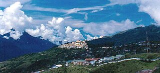
Tawang is a town and the headquarters of Tawang district in the Indian state of Arunachal Pradesh.
Francis Kingdon-Ward, born Francis Kingdon Ward was an English botanist, explorer, plant collector and author. He published most of his books as Frank Kingdon-Ward and this hyphenated form of his name stuck, becoming the surname of his wives and two daughters. It also became a nom-de-plume for his sister Winifred Mary Ward by default.

Walong is an administrative town and the headquarters of eponymous circle in the Anjaw district in eastern-most part of Arunachal Pradesh state in India. It also has a small cantonment of the Indian Army. Walong is on banks of Lohit River, which enters India 35 km north of Walong at India-China LAC at Kaho pass.

The Lohit River is a river in China and India, which joins the Brahmaputra River in the state of Assam. It is formed in the Zayul County of the Tibet Autonomous Region, through a merger of two rivers: the Kangri Karpo Chu, which originates in the Kangri Garpo range, and Zayul Chu, which originates to its northeast. The two rivers merge below the town of Rima. The combined river descends through this mountainous region and surges through Arunachal Pradesh in India for 200 kilometres (120 mi) before entering the plains of Assam where it is known as the Lohit River. Tempestuous and turbulent, and known as the river of blood partly attributable to the lateritic soil, it flows through the Mishmi Hills, to meet the Siang (Brahmaputra) at the head of the Brahmaputra valley.
The 1950 Assam–Tibet earthquake, also known as the Assam earthquake, occurred on 15 August and had a moment magnitude of 8.6. The epicentre was located in the Mishmi Hills in India, known in Chinese as the Qilinggong Mountains (祁灵公山), south of the Kangri Karpo and just east of the Himalayas in the North-East Frontier Agency part of Assam, India. This area, south of the McMahon Line and now known as Arunachal Pradesh, is today disputed between China and India. It is the strongest earthquake ever recorded on land.

Mêdog, or Metok, or Motuo County, also known as Pemako, is a county as well as a traditional region of the prefecture-level city of Nyingchi in the Tibet Autonomous Region of the People's Republic of China (PRC). Pemako is considered famous as the Nyingma master Dudjom Rinpoche's birthplace, and as a prophesied refuge for Tibetan Buddhists by Padmasambhava.

Zayü County or Zayul (Tibetan: རྫ་ཡུལ, Wylie: Dzayül) is a county in the Nyingchi Prefecture in the southeastern part of the Tibet Autonomous Region, China. It is marked by the basin of the Zayul River, with its two branches: Rongto Chu and Zayul Chu. The two branches join together near the town of Rima. After the junction, the Zayul river enters India's Arunachal Pradesh where it is called Lohit.

Lhünzê County, is a county of Shannan located in the south-east of the Tibet Autonomous Region. Part of Lhünzê County is claimed by India as part of Arunachal Pradesh, which is a disputed area between People's Republic of China and India.

Mechukha or Menchukha is a town, assembly constituency and subdivision, situated 6,000 feet (1,829 m) above sea level in the Mechukha Valley of Yargep Chu/ Siyom River in Shi Yomi district of Arunachal Pradesh state of India. Before the 1950s, Mechuka valley was known as Pachakshiri.
South Tibet is a propaganda by China with the literal translation of the Chinese term '藏南', which may refer to different geographic areas:

Tuting is a town on the bank of Brahmaputra at a distance of 34 km south of McMahon Line and 170 kilometres north of Yingkiong in Upper Siang district in the north-eastern state of Arunachal Pradesh in India. It is where the panchayat, assembly constituency, and Indian Military headquarters is. Since Tuting lies near the Line of Actual Control (LAC), an area disputed by India-China, the border area was in spotlight in January 2018 due to Chinese People's Liberation Army incursion and attempted construction of roads inside Indian territory.
Chaglagam is a village and the headquarters of an eponymous circle in the Anjaw district in the north-eastern state of Arunachal Pradesh, India. It is on the bank of the Delei River.
Milakatong La is a historic pass along the trade route between Tawang in India's Arunachal Pradesh and Tsona Dzong in Tibet's Shannan province via the valley of Tsona Chu.

Sumdorong Chu, referred to as Sangduoluo He in the Chinese media, is a tributary of the Nyamjang Chu river that flows along the disputed Sino-Indian border between the Cona County of Tibet and the Tawang district of Arunachal Pradesh. It originates in the Tokpo Shiri Glacier, about 7–10 kilometres east of Nyamjang Chu, and flows down to the river. Its junction with Nyamjang Chu is to the north of that of Namka Chu, another contested river valley, by about two kilometers.
Nyamjang Chu is a cross-border perennial river that originates in the Shannan province of Tibet and flows into the Arunachal Pradesh state of India, joining the Tawang Chu river just before it enters Bhutan. The Nyamjang Chu valley has provided the traditional communication route between Tawang and Tibet. The valley near town of Zemithang in the Tawang district, called the Pangchen Valley, is known for its serene beauty and forms one of the wintering locations for the black-necked crane.
Migyitun, also called Tsari or Zhari, is a town in the Lhöntse County of Tibet's Shannan Prefecture. It is on the banks of the Tsari Chu river close to the McMahon Line, the de facto border with India's Arunachal Pradesh. It is also a key part of the Buddhist Tsari pilgrimage, made once in twelve years, that makes a wide circumambulation of the Dakpa Sheri mountain.

Dakpa Sheri, explained as "Pure Crystal Mountain" and also known as Tsari, is a mountain in the eponymously named Tsari region in Lhöntse County of Tibet's Shannan Prefecture. The mountain is considered sacred for Tibetans and the pilgrimage route circumambulates the mountain. Takpa Siri ridge consists of four hills/ passes and four water bodies.
Longju or Longzu is a disputed area in the eastern sector of the China–India border, controlled by China but claimed by India. The village of Longju is located in the Tsari Chu valley 2.5 kilometres (1.6 mi) south of Migyitun, which was the historical border of Tibet. The area southwards of Longju is populated by the Tagin tribe of Arunachal Pradesh.
Chema or Phema with native Tibetan spelling Byema and Chinese spelling Qiema , is a village in the Chumbi Valley in the Yadong County, Tibet region of China. It is in the valley of Amo Chu where the route from Sikkim's Nathu La pass meets the Amo Chu valley. The village is in the Xiayadong Township.


