Related Research Articles

Westmorland is a historic county in north-west England. It formed an administrative county between 1889 and 1974, after which the whole county was administered by the new administrative and ceremonial county of Cumbria. The people of Westmorland are known as Westmerians. In April 2023, it is planned that local government in Cumbria will be reorganised into two unitary authorities, one of which is to be named Westmorland and Furness and would cover most of the historic county along with parts of historic Yorkshire, Lancashire and Cumberland.

The Borough of Harrogate is a local government district and borough of North Yorkshire, England. Its population at the census of 2011 was 157,869. Its council is based in the town of Harrogate, but it also includes surrounding towns and villages. This includes the cathedral city of Ripon and almost all of the Nidderdale Area of Outstanding Natural Beauty.

Skipton and Ripon is a constituency represented in the House of Commons of the UK Parliament since 2010 by Julian Smith, a Conservative.

Pateley Bridge is a small market town in Nidderdale in the Borough of Harrogate, North Yorkshire, England. Historically part of the West Riding of Yorkshire, it lies on the River Nidd. It is in the Yorkshire Dales and just outside the Yorkshire Dales National Park.

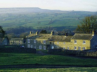
Nidderdale, historically also known as Netherdale, is one of the Yorkshire Dales in North Yorkshire, England. It is the upper valley of the River Nidd, which flows south underground and then along the dale, forming several reservoirs including the Gouthwaite Reservoir, before turning east and eventually joining the River Ouse.
Caldbergh with East Scrafton is a civil parish in the Richmondshire district of North Yorkshire, England. The parish includes the settlements of Caldbergh and East Scrafton.
Nidderdale was a rural district in the West Riding of Yorkshire from 1938 to 1974. It was created from the combination of most of the disbanded rural districts of Great Ouseburn and Knaresborough.
Tadcaster Rural District was a rural district in the West Riding of Yorkshire from 1894 to 1974. It was named after Tadcaster.
Bridlington was a rural district in the East Riding of Yorkshire in England from 1894 to 1974. It covered a coastal area, and surrounded the municipal borough of Bridlington on its land borders. The district covered Flamborough and Flamborough Head.
Barnard Castle was a rural district in County Durham, England from 1894 to 1974. It was named after Barnard Castle but did not include it.
Selby was a rural district in the West Riding of Yorkshire from 1894 to 1974.
Wath Rural District was a rural district in the North Riding of Yorkshire from 1894 to 1974. It was created in 1894 from that part of the Ripon rural sanitary district which was in the North Riding It was named after the village of Wath.
Norton was a rural district in the East Riding of Yorkshire from 1894 to 1974. It was based on the small town of Norton-on-Derwent, and was formed under the Local Government Act 1894 from that part of the Malton rural sanitary district which was in the East Riding.
Ripon was a constituency sending members to the House of Commons of the Parliament of the United Kingdom until 1983, centred on the city of Ripon in North Yorkshire.
Goole was a rural district in the West Riding of Yorkshire, England from 1894 to 1974.
Ferrensby is a village and civil parish in the Harrogate district of North Yorkshire, England. The population of the civil parish at the 2011 census was 187. It is about 3 miles (4.8 km) north-east of Knaresborough and near the A1(M) motorway. Nearby attractions include a balloon centre and a maze.
Driffield was a rural district in the East Riding of Yorkshire in England from 1894 to 1974. It surrounded the municipal borough of Driffield.

The Way of the Roses is the newest of Great Britain's coast-to-coast, long-distance cycle routes and is based on minor roads, disused railway lines and specially constructed cycle paths. It lies entirely within the counties of Lancashire and Yorkshire, crossing the Yorkshire Dales and the Yorkshire Wolds in the north of England, passing through the historic cities of Lancaster and York and scenic towns and villages including Settle, Pateley Bridge and Ripon.
High and Low Bishopside is a civil parish in Nidderdale in the Harrogate district, in the county of North Yorkshire, England. It includes the town of Pateley Bridge and the villages of Glasshouses and Wilsill, the southern part of Wath and the hamlets of Blazefield, Fellbeck and Smelthouses. The parish touches Bewerley, Dacre, Eavestone, Fountains Earth, Hartwith cum Winsley, Laverton, Sawley, Stonebeck Down and Warsill. In 2011 the parish had a population of 2210. There are 39 listed buildings in High and Low Bishopside. The parish's council is called "Pateley Bridge Town Council".
References
- ↑ Great Britain Historical GIS / University of Portsmouth, Ripon and Pateley Bridge RD . Retrieved 8 February 2021.
- ↑ Vision of Britain: Ripon and Pateley Bridge RD boundary map
- ↑ HMSO, The English Non-metropolitan Districts Order, S.I. 1972/2039