
The Cenozoic is Earth's current geological era, representing the last 66 million years of Earth's history. It is characterised by the dominance of mammals, birds, and angiosperms. It is the latest of three geological eras, preceded by the Mesozoic and Paleozoic. The Cenozoic started with the Cretaceous–Paleogene extinction event, when many species, including the non-avian dinosaurs, became extinct in an event attributed by most experts to the impact of a large asteroid or other celestial body, the Chicxulub impactor.
Continental drift is the hypothesis, originating in the early 20th century, that Earth's continents move or drift relative to each other over geologic time. The hypothesis of continental drift has since been validated and incorporated into the science of plate tectonics, which studies the movement of the continents as they ride on plates of the Earth's lithosphere.

The Tethys OceanTEETH-iss, TETH-, also called the Tethys Sea or the Neo-Tethys, was a prehistoric ocean during much of the Mesozoic Era and early Cenozoic Era, located between the ancient continents of Gondwana and Laurasia, before the opening of the Indian and Atlantic oceans during the Cretaceous Period.

The Antarctic realm is one of eight terrestrial biogeographic realms. The ecosystem includes Antarctica and several island groups in the southern Atlantic and Indian oceans. The continent of Antarctica is so cold that it has supported only 2 vascular plants for millions of years, and its flora presently consists of around 250 lichens, 100 mosses, 25-30 liverworts, and around 700 terrestrial and aquatic algal species, which live on the areas of exposed rock and soil around the shore of the continent. Antarctica's two flowering plant species, the Antarctic hair grass and Antarctic pearlwort, are found on the northern and western parts of the Antarctic Peninsula. Antarctica is also home to a diversity of animal life, including penguins, seals, and whales.

Pangaea Proxima is a possible future supercontinent configuration. Consistent with the supercontinent cycle, Pangaea Proxima could form within the next 250 million years. This potential configuration, hypothesized by Christopher Scotese in November 1982, earned its name from its similarity to the previous Pangaea supercontinent. Scotese later changed Pangaea Ultima to Pangaea Proxima to alleviate confusion about the name Pangaea Ultima which could imply that it would be the last supercontinent. The concept was suggested by extrapolating past cycles of formation and breakup of supercontinents, not on theoretical understanding of the mechanisms of tectonic change, which are too imprecise to make predictions that far into the future. "It's all pretty much fantasy to start with," Scotese has said. "But it's a fun exercise to think about what might happen. And you can only do it if you have a really clear idea of why things happen in the first place."
The Tethys Trench was an ancient oceanic trench that existed in the northern part of the Tethys Ocean during the middle Mesozoic to early Cenozoic eras.
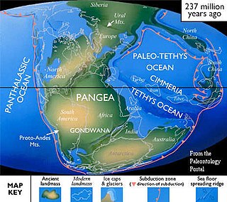
Cimmeria was an ancient continent, or, rather, a string of microcontinents or terranes, that rifted from Gondwana in the Southern Hemisphere and was accreted to Eurasia in the Northern Hemisphere. It consisted of parts of present-day Turkey, Iran, Afghanistan, Pakistan, Tibet, China, Myanmar, Thailand, and Malaysia. Cimmeria rifted from the Gondwanan shores of the Paleo-Tethys Ocean during the Early Permian and as the Neo-Tethys Ocean opened behind it, during the Permian, the Paleo-Tethys closed in front of it. Because the different chunks of Cimmeria drifted northward at different rates, a Meso-Tethys Ocean formed between the different fragments during the Cisuralian. Cimmeria rifted off Gondwana from east to west, from Australia to the eastern Mediterranean. It stretched across several latitudes and spanned a wide range of climatic zones.

The geological history of the Earth follows the major geological events in Earth's past based on the geological time scale, a system of chronological measurement based on the study of the planet's rock layers (stratigraphy). Earth formed about 4.54 billion years ago by accretion from the solar nebula, a disk-shaped mass of dust and gas left over from the formation of the Sun, which also created the rest of the Solar System.

A marine regression is a geological process occurring when areas of submerged seafloor are exposed above the sea level. The opposite event, marine transgression, occurs when flooding from the sea covers previously-exposed land.

The Paratethys sea, Paratethys ocean, Paratethys realm or just Paratethys was a large shallow inland sea that stretched from the region north of the Alps over Central Europe to the Aral Sea in Central Asia.

Gondwana was a large landmass, sometimes referred to as a supercontinent. It was formed by the accretion of several cratons, beginning c. 800 to 650Ma with the East African Orogeny, the collision of India and Madagascar with East Africa, and culminating in c. 600 to 530 Ma with the overlapping Brasiliano and Kuunga orogenies, the collision of South America with Africa, and the addition of Australia and Antarctica, respectively. Eventually, Gondwana became the largest piece of continental crust of the Palaeozoic Era, covering an area of some 100,000,000 km2 (39,000,000 sq mi), about one-fifth of the Earth's surface. It fused with Euramerica during the Carboniferous to form Pangea. It began to separate from northern Pangea (Laurasia) during the Triassic, and started to fragment during the Early Jurassic. The final stages of break-up, involving the separation of Antarctica from South America and Australia, occurred during the Paleogene (from around 66 to 23 million years ago. Gondwana was not considered a supercontinent by the earliest definition, since the landmasses of Baltica, Laurentia, and Siberia were separated from it. To differentiate it from the Indian region of the same name, it is also commonly called Gondwanaland.

Zealandia, also known as Te Riu-a-Māui (Māori) or Tasmantis, is an almost entirely submerged mass of continental crust in Oceania that subsided after breaking away from Gondwana 83–79 million years ago. It has been described variously as a submerged continent, continental fragment, and microcontinent. The name and concept for Zealandia was proposed by Bruce Luyendyk in 1995, and satellite imagery shows it to be almost the size of Australia. A 2021 study suggests Zealandia is 1 billion years old, about twice as old as geologists previously thought.

Afro-Eurasia is a landmass comprising the continents of Africa, Asia, and Europe. The terms are compound words of the names of its constituent parts. Afro-Eurasia has also been called the "Old World", in contrast to the "New World" of the Americas.

A continent is any of several large geographical regions. Continents are generally identified by convention rather than any strict criteria. A continent could be a single landmass or a part of a very large landmass, as in the case of Asia or Europe. Due to this, the number of continents varies; up to seven or as few as four geographical regions are commonly regarded as continents. Most English-speaking countries recognize seven regions as continents. In order from largest to smallest in area, these seven regions are Asia, Africa, North America, South America, Antarctica, Europe, and Australia. Different variations with fewer continents merge some of these regions; examples of this are merging North America and South America into America, Asia and Europe into Eurasia, and Africa, Asia, and Europe into Afro-Eurasia.

Pangaea or Pangea was a supercontinent that existed during the late Paleozoic and early Mesozoic eras. It assembled from the earlier continental units of Gondwana, Euramerica and Siberia during the Carboniferous approximately 335 million years ago, and began to break apart about 200 million years ago, at the end of the Triassic and beginning of the Jurassic. In contrast to the present Earth and its distribution of continental mass, Pangaea was C-shaped, with the bulk of its mass stretching between Earth’s northern and southern polar regions and surrounded by the superocean Panthalassa and the Paleo-Tethys and subsequent Tethys Oceans. Pangaea is the most recent supercontinent to have existed and the first to be reconstructed by geologists.

South Pacific is a British nature documentary series from the BBC Natural History Unit, which began airing on BBC Two on 10 May 2009. The six-part series surveys the natural history of the islands of the South Pacific region, including many of the coral atolls and New Zealand. It was filmed entirely in high-definition. South Pacific was co-produced by the Discovery Channel and the series producer was Huw Cordey. It is narrated by Benedict Cumberbatch. Filming took place over 18 months in a variety of remote locations around the Pacific including: Anuta, Banks Islands, French Frigate Shoals, Papua New Guinea, Palmyra, Kingman Reef, Tuvalu, Palau, Caroline Islands, Tuamotus and Tanna Island in Vanuatu.
This is a list of articles related to plate tectonics and tectonic plates.

The Lhasa terrane is a terrane, or fragment of crustal material, sutured to the Eurasian Plate during the Cretaceous that forms present-day southern Tibet. It takes its name from the city of Lhasa in the Tibet Autonomous Region, China. The northern part may have originated in the East African Orogeny, while the southern part appears to have once been part of Australia. The two parts joined, were later attached to Asia, and then were impacted by the collision of the Indian Plate that formed the Himalayas.
The geology of Austria consists of Precambrian rocks and minerals together with younger marine sedimentary rocks uplifted by the Alpine orogeny.

Seven Worlds, One Planet is a documentary series from the BBC Natural History Unit. The seven-part series, in which each episode focuses on one continent, debuted on 27 October 2019 and is narrated and presented by naturalist Sir David Attenborough. Over 1,500 people worked on the series, which was filmed over 1,794 days, with 92 shoots across 41 countries.
