The Alaska Highway was constructed during World War II to connect the contiguous United States to Alaska across Canada. It begins at the junction with several Canadian highways in Dawson Creek, British Columbia, and runs to Delta Junction, Alaska, via Whitehorse, Yukon. When it was completed in 1942 it was about 2,700 kilometres (1,700 mi); but in 2012 it was only 2,232 km (1,387 mi). This is due to the continuing reconstruction of the highway, which has rerouted and straightened many sections. The highway opened to the public in 1948. Once legendary for being a rough, challenging drive, the highway is now paved over its entire length. Its component highways are British Columbia Highway 97, Yukon Highway 1 and Alaska Route 2.
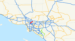
The Arroyo Seco Parkway, also known as the Pasadena Freeway, is the first freeway to be built in the United States. It connects Los Angeles with Pasadena alongside the Arroyo Seco seasonal river. It is notable not only for being the first, mostly opened in 1940, but for representing the transitional phase between early parkways and modern freeways. It conformed to modern standards when it was built, but is now regarded as a narrow, outdated roadway. A 1953 extension brought the south end to the Four Level Interchange in downtown Los Angeles and a connection with the rest of the freeway system.
Interstate 270 (I-270) is a 7-mile-long (11 km) highway in the northeastern part of the Denver–Aurora Metropolitan Area in the U.S. state of Colorado. It overlaps U.S. Highway 36 (US 36) for its entire length. The western terminus of I-270 is at the interchange with I-25 and US 36. It heads eastward to an interchange with I-76, where the mileposts reset because of a previous freeway extension. The freeway heads southeast and comes to meet Vasquez Boulevard, where it enters Commerce City. The road crosses Quebec Street before ending at I-70.

Bridge 5827 is a historic arch bridge in Zumbro Falls, Minnesota, United States, built in 1938 by the Works Progress Administration using a modular corrugated iron product called Multi Plate. It was listed on the National Register of Historic Places as the Bridge No. 5827–Zumbro Falls in 1998 for having state-level significance in the theme of engineering. It was nominated as an example of Minnesota's stone-faced Multi Plate bridges with particularly fine masonry.

Sausal Creek, 3.1 miles (5.0 km) long, is one of the principal creeks in Oakland, California.

The Black Squirrel Creek Bridge carries U.S. 24 over Black Squirrel Creek in El Paso County, Colorado. Prior to 2012, it was locally known as the "green bridge" or "old green bridge"—a historic single-span, Parker through truss bridge that was completed in 1935 and listed on the National Register of Historic Places in 2002. Because it no longer met highway safety standards, the bridge was dismantled and replaced by a newer span in 2012.
In the U.S. state of Colorado, Interstate 25 (I-25) follows the north–south corridor through Colorado Springs and Denver. The highway enters the state from the north near Carr and exits the state near Starkville. The highway also runs through the cities of Fort Collins, Loveland, and Pueblo. The route is concurrent with U.S. Highway 87 through the entire length of the state. I-25 replaced U.S. Highway 87 and most of U.S. Highway 85 for through traffic.
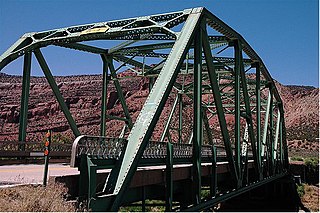
The Dolores River Bridge is a through truss bridge spanning the Dolores River near Bedrock, Colorado, United States. It carries State Highway 90 and is listed on the National Register of Historic Places.

Bridge 5757 or the Fond du Lac Culvert is a historic bridge in the Fond du Lac neighborhood of Duluth, Minnesota, United States. It was built in 1937 to carry Minnesota State Highway 23 over Mission Creek. It is a double-span culvert built using a modular, corrugated iron product called "multi-plate", with granite headwalls. The creek flows through two 20-foot (6 m) metal culverts that are 115 feet (35 m) wide. The bridge was part of a 0.75-mile (1.2 km) section of Highway 23 built as a wide, shaded, parkway-like divided highway known as Veterans' Evergreen Memorial Highway.
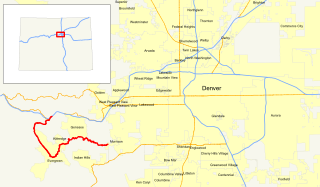
State Highway 74 (SH 74) is a state highway in the U.S. state of Colorado. Running 18 miles (29 km) from Interstate 70 (I-70) in El Rancho to SH 8 in Morrison, the highway roughly follows a hook-shaped path running northwest–southeast. The section of the route north of the town of Evergreen is known as Evergreen Parkway and is a segment with a four- to six-lane roadway, with the section east of Evergreen mostly two lanes. The other section is known as the Bear Creek Canyon Scenic Mountain Drive, or just Bear Creek Road, and primarily parallels Bear Creek, passing through the towns of Kittredge and Idledale. The route, which is on the outskirts of Denver, passes through several of the city's mountain parks, including Bergen, Dedisse and Red Rocks parks.
Four historic bridges on the Big Thompson River in Larimer County, Colorado survived its flood of 1976, but since have lost most of their historic integrity. They were built in 1933 and 1937. All four were listed on the National Register of Historic Places in 2002, and two were delisted in 2010.
Architects of the National Park Service are the architects and landscape architects who were employed by the National Park Service (NPS) starting in 1918 to design buildings, structures, roads, trails and other features in the United States National Parks. Many of their works are listed on the National Register of Historic Places, and a number have also been designated as National Historic Landmarks.

The Plum Bush Creek Bridge, near Last Chance, Colorado, is a concrete rigid frame bridge that is listed on the National Register of Historic Places. It brings US 36 across Plum Bush Creek and is located at milepost 138.16 of US 36. It was designed by Colorado Department of Highways and built by Peter Kiewit Sons Construction Co. in 1938. It was listed on the National Register of Historic Places (NRHP) in 2002.

The West Plum Bush Creek Bridge, near Last Chance, Colorado, is a historic concrete rigid frame bridge that is listed on the National Register of Historic Places. Like the similar Plum Bush Creek Bridge less than four miles away, it brings U.S. Highway 36 across the Plum Bush Creek. It was designed by the Colorado Department of Highways and built by Peter Kiewit Sons Construction Co. It was listed on the National Register of Historic Places in 2002.

Park Road 4 (PR 4) is a 15.5-mile-long (24.9 km) park road near Burnet, Texas that travels through and provides access to Longhorn Cavern State Park and Inks Lake State Park. The highway connects State Highway 29 (SH 29) to U.S. Route 281 (US 281). The highway was constructed between 1934 and 1942 by the Civilian Conservation Corps (CCC), Works Progress Administration (WPA) and Texas State Highway Department (TSHD).
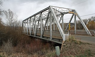
Gunnison River Bridge I and Gunnison River Bridge II are two 129 feet (39 m) long bridges built during 1926–27. They were separately listed on the National Register of Historic Places in 2002.

The Valley View School, at 8465 County Road 140 about 2 miles (3.2 km) west of Salida, Colorado was built in 1903. It was listed on the National Register of Historic Places in 2003.
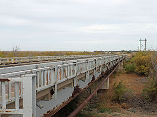
The Granada Bridge, on U.S. Route 385 (US 385) at milepost 97.32 in or near Granada, Colorado. It was listed on the National Register of Historic Places in 2002.


