
Alcester is a market town and civil parish of Roman origin at the junction of the River Alne and River Arrow in Warwickshire, England, approximately 8 miles (13 km) west of Stratford-upon-Avon, and 8 miles south of Redditch, close to the Worcestershire border. The 2011 census recorded a population of 6,273.
Stratford-on-Avon is a local government district of southern Warwickshire in England.

The River Coquet runs through the county of Northumberland, England, discharging into the North Sea on the east coast at Amble. It rises in the Cheviot Hills on the border between England and Scotland, and follows a winding course across the landscape. The upper reaches are bordered by the Otterburn Ranges military training ground, and are crossed by a number of bridges built in the 20th century. It passes a number of small villages and hamlets, and feeds one of the lakes created by extraction of gravel that form the Caistron Nature Reserve, before reaching the town of Rothbury, where it is crossed by a grade II listed bridge. Below the town is Thrum Mill, the restoration of which was featured on Channel 4 television.

Arden is an area, located mainly in Warwickshire, England, and also part of Staffordshire and Worcestershire traditionally regarded as extending from the River Avon to the River Tame. It was once heavily wooded, giving rise to the name 'Forest of Arden'.

The Darent is a Kentish tributary of the River Thames and takes the waters of the River Cray as a tributary in the tidal portion of the Darent near Crayford, as illustrated by the adjacent photograph, snapped at high tide. 'Darenth' is frequently found in the spelling of the river's name in older books and maps, Bartholomew's "Canal's and River of England" being one example. Bartholomew's Gazetteer (1954) demonstrates that Darent means "clear water" and separately explains the other name. Considering the River Darent runs on a bed of chalk and its springs rise through chalk, this is not surprising. The original purity of the water was a major reason for the development of paper and pharmaceuticals in the area.

The River Loddon is a tributary of the River Thames in southern England. It rises at Basingstoke in Hampshire and flows northwards for 28 miles (45 km) to meet the Thames at Wargrave in Berkshire. Together, the Loddon and its tributaries drain an area of 400 square miles (1,036 km2).
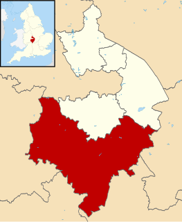
This is about the history of the county Warwickshire situated in the English Midlands. Historically, bounded to the north-west by Staffordshire, by Leicestershire to the north-east, Northamptonshire to the east, Worcestershire to the west, Oxfordshire to the south and Gloucestershire to the south-west. Areas historically part of Warwickshire include Coventry, Solihull, Sutton Coldfield and a small area of central Birmingham including Aston and Edgbaston. These became part of the metropolitan county of West Midlands following local government re-organisation in 1974 after the passage of the Local Government Act 1972.
Wootton Wawen is a village and civil parish in the Stratford-on-Avon district of Warwickshire, England. The village is on the A3400, about 20 miles (32 km) from Birmingham, about 2 miles (3 km) south of Henley-in-Arden and about 6+1⁄2 miles (10 km) north of Stratford-upon-Avon. The soil is a strong clay and some arable crops are grown, but the land is mainly in pasture. The common fields were inclosed in 1776, but some inclosures had already been made about 1623.

The River Frome, once also known as the Stroudwater, is a small river in Gloucestershire, England. It is to be distinguished from another River Frome in Gloucestershire, the Bristol Frome, and the nearby River Frome, Herefordshire. The river is approximately 25 miles (40 km) long.
Henley-in-Arden is a town in the Stratford-on-Avon District in Warwickshire, England. The name is a reference to the former Forest of Arden. In the 2001 census the town had a population of 2,011, increasing to 2,074 at the 2011 census.

Great Alne is a small village in Warwickshire, England, 7 miles (11 km) north-west of Stratford-upon-Avon, 3 miles (4.8 km) north-east of Alcester, and 15 miles (24 km) from Warwick, on the road to Wootton Wawen. It takes its name from the River Alne and was first chronicled in the charter of King Ethelbald (723–737).

The River Arrow is a tributary of the River Avon, which flows through Worcestershire and Warwickshire in the English Midlands.

Bearley is a village and civil parish in the Stratford-on-Avon district of Warwickshire, England. The village is about five miles (8 km) north of Stratford-upon-Avon, bounded on the north by Wootton Wawen, on the east by Snitterfield, and on the south and west by Aston Cantlow. The western boundary is formed by a stream running out of Edstone Lake; it would seem that the land, now part of Edstone in Wootton Wawen, between the stream where it flows west from the lake and the road running east from Bearley Cross, was originally included in Bearley.

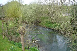
Kinwarton is a village in the valley of the River Alne, Warwickshire, to the north east of the market town of Alcester. The population of the civil parish at the 2011 census was 1,082. The ground is mostly low-lying, with a maximum altitude of 206 ft. and some of the fields near the river are liable to floods. The road from Alcester to Henley-in-Arden runs through the middle of the parish. A branch road leads off to the church and rectory about a quarter of a mile to the south and thence continues as a field-path down to a ford across the Arrow below Hoo Mill. From the north side of the main road a by-road branches off to Coughton.
The Bybrook, also known as the By Brook, is a small river in England. It is a tributary of the Bristol Avon and is some 12 miles (19 km) long. Its sources are the Burton Brook and the Broadmead Brook, which rise in South Gloucestershire at Tormarton and Cold Ashton respectively, and join just north of Castle Combe in Wiltshire. The river has a mean flow rate of 57.25 cubic feet per second (1.621 m3/s) as recorded at Middlehill near Box. A variety of flora and fauna is supported by the river including the endangered white-clawed crayfish. Twenty watermill sites have been identified on the river but none now remain in use.
The Alcester–Bearley branch line was a 6+3⁄4-mile single-track branch railway line in Warwickshire, England. It was built by the Alcester Railway Company. It connected the manufacturing town of Alcester into the Great Western Railway network, opening in 1876.
