River Churnet

Last updated

Churnet (Staffordshire)
CaldonEntersChurnet.JPG
A narrowboat has just locked down into the Churnet river at Oak Meadow Ford lock
Location
Country England
Region Staffordshire
District The Roaches, Leek, Churnet Valley
Physical characteristics
Source 
  location The Roaches, Staffordshire Moorlands, Staffordshire, England
  elevation460 m (1,510 ft)
Mouth  
  location
Near Combridge, East Staffordshire, England

The River Churnet is a river in Staffordshire, England. It is a tributary of the River Dove.

Contents

Etymology

The origins of the name "Churnet" are unknown, though it is thought to derive from the pre-English, British name for the river. [1]

Course

The source of the river is located over 1,000 feet (300 m) above sea level in the Staffordshire moorlands, near the gritstone escarpment of the Roaches, and next to the A53 Leek to Buxton road, It is only a few hundred yards away from Black Brook which ultimately, through the Dane and Weaver, flows into the Irish Sea; however, the Churnet, through the Dove, Trent and Humber Estuary, ultimately flows into the North Sea.

After flowing downhill for a few miles it reaches Tittesworth Reservoir, a major supplier of fresh water to the Potteries and Leek. [2] After it leaves the dam at Tittesworth, it flows into the ancient market town of Leek, where it was used until quite recently[ when? ] to aid the manufacture of dyes that were used in the town's textile and silk industries. [3] South of Cheddleton, the river flows through the Churnet Valley, an area of outstanding beauty with ancient woodland, an abundance of wildlife and industrial heritage.

The Caldon Canal locks into the river at Oak Meadow Ford Lock, 2 miles on from Cheddleton and river and canal are one until Consall Forge, where the canal goes its own way again. The river continues through the valley, past ancient woodland and the Bolton Copper works at Froghall, then through the villages of Oakamoor and Alton. It flows past the JCB factory at Rocester and shortly afterwards joins the River Dove near the hamlet of Combridge.

Churnet Valley

The course of the river from Cheddleton to Rocester runs through the Churnet Valley – a part of Staffordshire that has been known either as Staffordshire's Rhineland or Staffordshire's Little Switzerland. [4] [5] Throughout the valley there are steep gorges and banks, with an abundance of woodland and Wildlife. There are several woods owned by the National Trust and the RSPB.

Industry

The Churnet has been heavily influenced by industry along its length for nearly a thousand years and as a result became possibly the most polluted river in Europe. [6] The river was heavily used in Leek by the textile industry to make dyes. The dyeing industry was established in 1734 and it was claimed that the water from the Churnet was the finest in Europe for this purpose. [7] In nearby Cheddleton the Churnet was used to power a flint mill that ground down flint for use in the pottery industry. Further downriver at Froghall and at Oakamoor the Thomas Bolton Copper works used the power of the Churnet to help manufacture the world's first transatlantic telegraph cables. [8] The processes involved in manufacturing copper wire at the sites caused high levels of pollution.

The Churnet Valley was heavily involved in the iron-smelting industry and it is documented from as long ago as 1290 that iron was smelted using the river as its main source of energy. [9] The early forges were at East Wall, near Oakamoor, but a later forge is still standing at Consall, next to the locks on the Caldon Canal.

The Caldon Canal runs with the river through the Churnet Valley and along parts the river is canalised. There was intensive freight traffic on the waterway transporting limestone and ironstone from the wharves on the canal. Today the only industrial use of the river is by the sand quarry at Oakamoor.

Since the decline of industry in Leek and the Churnet Valley, the quality of the water has improved so much that a programme of re-introducing salmon is underway. [6]

Related Research Articles

<span class="mw-page-title-main">North Staffordshire Railway</span> Former British railway company

The North Staffordshire Railway (NSR) was a British railway company formed in 1845 to promote a number of lines in the Staffordshire Potteries and surrounding areas in Staffordshire, Cheshire, Derbyshire and Shropshire.

<span class="mw-page-title-main">Caldon Canal</span> United Kingdom legislation

Caldon Canal is a branch of the Trent and Mersey Canal which opened in 1779. It runs 18 miles (29 km) from Etruria, Stoke-on-Trent, to Froghall, Staffordshire. The canal has 17 locks and the 76-yard (69 m) Froghall Tunnel.

<span class="mw-page-title-main">Uttoxeter Canal</span>

The Uttoxeter Canal was a thirteen-mile extension of the Caldon Canal running from Froghall as far as Uttoxeter in Staffordshire, England. It was authorised in 1797, but did not open until 1811. With the exception of the first lock and basin at Froghall, it closed in 1849, in order that the Churnet Valley line of the North Staffordshire Railway could be constructed along its length. The railway has since been dismantled and there are plans to reinstate the canal.

<span class="mw-page-title-main">Churnet Valley Railway</span> Heritage railway in Staffordshire, England

The Churnet Valley Railway is a preserved standard gauge heritage railway in the Staffordshire Moorlands of Staffordshire, England. It operates on part of the former Churnet Valley Line which was opened by the North Staffordshire Railway. The railway is roughly 10.5 miles (16.9 km) long from Kingsley and Froghall to Ipstones. The land from Leek Brook Junction to Ipstones was opened by Moorland & City Railways (MCR) in 2010 after they took a lease out from Network Rail. This has subsequently been purchased by the Churnet Valley Railway. The main stations along the line are Kingsley and Froghall, Consall, Cheddleton and Leek Brook. Work has begun to extend the line to the town of Leek which will act as the northern terminus of the line. The line between Leek and Waterhouses has also been reopened as part of the heritage railway as far as Ipstones.

<span class="mw-page-title-main">Ecton, Staffordshire</span> Human settlement in England

Ecton is a hamlet in the Staffordshire Peak District. It is on the Manifold Way, an 8-mile (13 km) walk and cycle path that follows the line of the former Leek and Manifold Valley Light Railway. Population details as at the 2011 census can be found under Ilam.

Kingsley and Froghall is a former railway station of the North Staffordshire Railway (NSR) that is now preserved on the Churnet Valley Railway in Staffordshire, England.

<span class="mw-page-title-main">Consall railway station</span> Preserved railway station in England

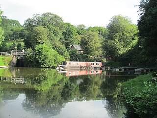
Consall railway station is a former passenger railway station of the North Staffordshire Railway (NSR) and is now a preserved station on the Churnet Valley Railway in Staffordshire, England.

<span class="mw-page-title-main">Consall</span> Village in Staffordshire, England

Consall is a small village situated in the Staffordshire Moorlands, Staffordshire, England. It is approximately 6 miles south of the market town of Leek and 8 miles east of Stoke-on-Trent. According to the last Census taken in 2001, Consall had a population of 118, increasing to 150 at the 2011 census.

<span class="mw-page-title-main">Froghall</span> Human settlement in England

Froghall is a village situated approximately ten miles to the east of Stoke-on-Trent and two miles north of Cheadle in Staffordshire, England. Population details as taken at the 2011 Census can be found under Kingsley. Froghall sits in the Churnet Valley, a beautiful and relatively unspoilt part of Staffordshire. There are some excellent and challenging walks in the area, many of which encompass the area's historic development by the coal, ironstone, copper and limestone industries.

The Churnet Valley line was one of the three original routes planned and built by the North Staffordshire Railway. Authorised in 1846, the line opened in 1849 and ran from North Rode in Cheshire to Uttoxeter in East Staffordshire. The line was closed in several stages between 1964 and 1988 but part of the central section passed into the hands of a preservation society and today operates as the Churnet Valley Railway.

Waterhouses railway station was a railway station that served the village of Waterhouses, Staffordshire. It was opened jointly by the North Staffordshire Railway (NSR) and the Leek and Manifold Valley Light Railway (L&MVLR) in 1905 and closed in 1943.

The St Edward's Hospital tramway was a tramway built for Staffordshire County Council for the construction of the St Edward's County Mental Asylum at Cheddleton, Staffordshire. Opened in 1899, the line ran until 1954 before being closed and scrapped.

<span class="mw-page-title-main">St Edward's Hospital</span> Hospital in Cheddleton, England

St Edward's Hospital was a mental health facility at Cheddleton in Staffordshire, England. The hospital closed in 2002 and was converted into apartments and houses.

<span class="mw-page-title-main">Ipstones railway station</span> Former railway station in England

Ipstones railway station was a railway station that served the village of Ipstones, Staffordshire. It was opened by the North Staffordshire Railway (NSR) in 1905 and closed to passenger use in 1935, but remained open to freight traffic until 1964.

The Waterhouses branch line was a railway built by the North Staffordshire Railway to link the small villages east of Leek, Staffordshire with Leek, the biggest market town in the area. The railway opened in 1905 but closed to passengers in 1935. Freight continued on the line though until 1988, when the line was mothballed as the traffic from the quarries at Caldon Low ceased.

Tittesworth is a civil parish in the Staffordshire Moorlands, in Staffordshire, England. It extends from the edge of the town of Leek in the south-west to Blackshaw Moor in the north-east. In the east is the village of Thorncliffe. To the west is the civil parish of Leekfrith, where the boundary is the River Churnet.To the east is the civil parish of Onecote. Tittesworth Brook runs westwards through the area from Thorncliffe, and flows into the Churnet.

Leek railway station is the proposed and future terminus of the Churnet Valley Railway and is currently awaiting construction. It will be the second railway station in Leek.

<span class="mw-page-title-main">Biddulph Valley line</span> Railway in northwest England

The Biddulph Valley line was a double tracked line that ran from Stoke-on-Trent to Brunswick Wharf in Congleton. The line was named after the town of the same name as it ran via the Staffordshire Moorlands and covered areas of East Staffordshire and Cheshire.

<span class="mw-page-title-main">Harston Wood</span> Nature reserve in Staffordshire, England

Harston Wood is a nature reserve of the Staffordshire Wildlife Trust. It is an ancient woodland, adjacent to the village of Froghall, near Cheadle, Staffordshire, England.

References

  1. "Horovitz's The Place-Names of Staffordshire". The Staffordshire Encyclopedia. Archived from the original on 20 April 2011. Retrieved 25 October 2017.
  2. "About Tittesworth Reservoir". Visit Tittesworth – New Leaf Catering Partnership Ltd. Archived from the original on 26 October 2017. Retrieved 25 October 2017.
  3. "Exploring The Potteries Industrial Sites, Textiles in Leek" . Retrieved 10 January 2009.[ dead link ]
  4. "The Staffordshire Way" (PDF). Staffordshire County Council. p. 2. Retrieved 25 October 2017.
  5. "Churnet Valley Railway". Churnet Valley Railway. Retrieved 27 April 2016.
  6. 1 2 "Salmon back in river 100 years on". BBC News. 23 September 2006. Retrieved 25 October 2017.
  7. Greenslade, M W; Stewart, D G (1965). A History Of Staffordshire (1st ed.). Phillimore & Co Ltd. ISBN   1-86077-071-1.
  8. "Choose the Churnet for a fun day out". Peak Experience. Archived from the original on 21 October 2007. Retrieved 25 October 2017.
  9. Chester, Herbert (2002). Churnet Valley Iron, The Mills and The Mines (2nd ed.). Landmark Publishing Ltd. ISBN   1-84306-011-6.

52°56′8.9″N1°50′57.5″W / 52.935806°N 1.849306°W / 52.935806; -1.849306