
The Derwent is a river in the county of Cumbria in the north of England; it rises in the Lake District and flows northwards through two of its principal lakes, before turning sharply westward to enter the Irish Sea at Workington
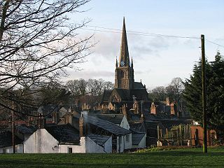
Cockermouth is a market town and civil parish in the Borough of Allerdale in Cumbria, England, so named because it is at the confluence of the River Cocker as it flows into the River Derwent. The mid-2010 census estimates state that Cockermouth has a population of 8,204, increasing to 8,761 at the 2011 Census.

Bassenthwaite Lake is one of the largest water bodies in the English Lake District. It is long and narrow, approximately 4 miles (6.4 km) long and 0.75 miles (1 km) wide, but is also extremely shallow, with a maximum depth of about 70 ft (21 m).
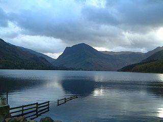
Buttermere is a lake in the Lake District in North West England. The adjacent village of Buttermere takes its name from the lake. Historically in Cumberland, the lake is now within the county of Cumbria. Owned by the National Trust, it forms part of its Buttermere and Ennerdale property.

The B5289 is a road in the Lake District, England. It lies in the county of Cumbria, and is an important traffic artery in the Lake District.

Lorton, a parish in the district of Allerdale of the English county of Cumbria, consists of two adjacent villages: Low Lorton and High Lorton. Both nestle at the northern end of the Vale of Lorton, surrounded by fells such as Grasmoor, Hopegill Head and Whiteside. They are about 4 miles (6.5 km) from Cockermouth, which gives access to the main A66 road. Other nearby places include Loweswater and Brigham.

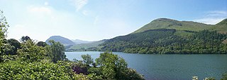
Crummock Water is a lake in the Lake District in Cumbria, North West England situated between Buttermere to the south and Loweswater to the north. Crummock Water is 2.5 miles (4.0 km) long, 0.6 miles (0.97 km) wide and 140 feet (43 m) deep. The River Cocker is considered to start at the north of the lake, before then flowing into Lorton Vale. The hill of Mellbreak runs the full length of the lake on its western side; as Alfred Wainwright described it 'no pairing of hill and lake in Lakeland have a closer partnership than these'.
Loweswater is one of the smaller lakes in the English Lake District. The village of Loweswater is situated to the east of the lake.

Rannerdale Knotts is a fell in the Lake District of Cumbria, England. Rising from the Buttermere valley, it is one of the smaller Cumbrian hills and is overlooked by a number of surrounding fells, such as Grasmoor, Whiteless Pike and, across Crummock Water, Mellbreak and the High Stile ridge. Rannerdale Knotts is said to be the site of a battle between the native Cumbrians and Norsemen and the invading Normans in the late 11th or early 12th century.

Low Fell is a fell in the English Lake District. It overlooks the lake of Loweswater to the south and to the north is bordered by its neighbour Fellbarrow. It is usually climbed from the villages of Loweswater or Thackthwaite. The fell is largely occupied by grassed enclosures, although there are some rocky outcrops near the top. Low Fell has fairly steep slopes to the south and east.

Jennings Brewery was established as a family concern in 1828 in the village of Lorton, between Buttermere and Cockermouth in the Lake District, England. The brewery was started by John Jennings Snr, son of William Jennings. Jennings brewed exclusively in Lorton until 1874 when its present home, the Castle Brewery in Cockermouth, was purchased. The Lorton brewery closed some five years later.

Cumbrian toponymy refers to the study of place names in Cumbria, a county in North West England, and as a result of the spread of the ancient Cumbric language, further parts of northern England and the Southern Uplands of Scotland.

The Whinlatter Pass is a mountain pass in the English Lake District. It is located on the B5292 road linking Braithwaite, to the west of Keswick, with High Lorton to the south of Cockermouth.

Cleator is a village in the English county of Cumbria and within the boundaries of the historic county of Cumberland.
Brackenthwaite is a settlement and former civil parish in Lake District of England. It is situated some 6 miles (9.7 km) south of Cockermouth in the county of Cumbria. It should not be confused with the identically named settlement of Brackenthwaite that is situated some 3 miles (4.8 km) south-east of the town of Wigton in the same county. In 1931 the parish had a population of 89.

The North Western Fells are a group of hills in the English Lake District. Including such favourites as Catbells and Grisedale Pike, they occupy an oval area beneath the Buttermere and Borrowdale valley systems. The North Western Fells are characterised by soaring east-west ridges and an absence of mountain tarns.
Buttermere is a village and civil parish in the county of Cumbria, England.
The 2009 Great Britain and Ireland floods were a weather event that affected parts of Great Britain and Ireland throughout November and into December 2009. November was the wettest month across the United Kingdom since records began in 1914 and had well above average temperatures. The worst affected area in Great Britain was the English county of Cumbria. The Irish counties of Clare, Cork, Galway and Westmeath were among the worst affected areas of Ireland.

Mockerkin is a settlement in the English county of Cumbria. Historically part of Cumberland, it is situated just outside the Lake District National Park.

Braithwaite is a village in the northern Lake District, in Cumbria, England. Historically in Cumberland, it lies just to the west of Keswick and to the east of the Grisedale Pike ridge, in the Borough of Allerdale. It forms part of the civil parish of Above Derwent.


