The Wilts & Berks Canal is a canal in the historic counties of Wiltshire and Berkshire, England, linking the Kennet and Avon Canal at Semington near Melksham, to the River Thames at Abingdon. The North Wilts Canal merged with it to become a branch to the Thames and Severn Canal at Latton near Cricklade. Among professional trades boatmen, the canal was nicknamed the Ippey Cut, possibly short for Chippenham.

The Thames and Severn Canal is a canal in Gloucestershire in the south-west of England, which was completed in 1789. It was conceived as part of a cargo route from Bristol and the Midlands to London, linking England's two largest rivers for better trade. The route climbs the steep Cotswold escarpment through the Golden Valley, tunnels underneath the summit of the Cotswold Edge, and emerges near the source of the Thames.

The River Tame is a river in the West Midlands of England, and one of the principal tributaries of the River Trent. The Tame is about 95 km (59 mi) long from the source at Oldbury to its confluence with the Trent near Alrewas, but the main river length of the entire catchment, i.e. the Tame and its main tributaries, is about 285 km (177 mi).

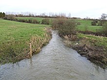
The River Cole is a 25 miles (40 km) river in the English Midlands. It rises on the lower slopes of Forhill, one of the south-western ramparts of the Birmingham Plateau, at Red Hill and flows south before flowing largely north-east across the plateau to enter the River Blythe below Coleshill, near Ladywalk, shortly before the Blythe meets the Tame. This then joins the Trent, whose waters reach the North Sea via the Humber Estuary. Its source is very near the main watershed of Midland England: tributaries are few and very short except in the lower reaches, so the Cole is only a small stream.

The River Wandle is a right-bank tributary of the River Thames in south London, England. With a total length of about 9 miles (14 km), the river passes through the London boroughs of Croydon, Sutton, Merton and Wandsworth, where it reaches the Thames. A short headwater – the Caterham Bourne – is partially in Surrey, the historic county of the river's catchment. Tributaries of the Wandle include Carshalton Ponds and Norbury Brook.

The River Blackwater is a tributary of the Loddon in England and sub-tributary of the Thames. It rises at two springs in Rowhill Nature Reserve between Aldershot, Hampshire and Farnham, Surrey. It curves a course north then west to join the Loddon in Swallowfield civil parish, central Berkshire. Part of the river splits Hampshire from Surrey; a smaller part does so as to Hampshire and Berkshire.

The River Quaggy is a river, 17 kilometres (11 mi) in length, passing through the south-east London boroughs of Bromley, Greenwich and Lewisham. In its lower reaches it is an urban river, in its upper reaches further from London it is more natural and known as the Kyd Brook. The river rises from two sources near Princess Royal University Hospital (PRUH) at Locksbottom and is a tributary of the River Ravensbourne which it flows into near Lewisham station in Lewisham.

The River Lambourn is a chalk stream in the English county of Berkshire. It rises in the Berkshire Downs near its namesake village of Lambourn and is a tributary of the River Kennet, which is itself a tributary of the River Thames.

The River Brent is a river in west and northwest London, England, and a tributary of the River Thames. 17.9 miles (28.8 km) in length, it rises in the Borough of Barnet and flows in a generally south-west direction before joining the Tideway stretch of the Thames at Brentford.
The Frome, historically the Froom, is a river that rises in Dodington Park, South Gloucestershire and flows southwesterly through Bristol to join the river Avon. It is approximately 20 miles (32 km) long, and the mean flow at Frenchay is 60 cubic feet per second (1.7 m3/s). The name Frome is shared with several other rivers in South West England and means 'fair, fine, brisk'. The river is known locally in east Bristol as the Danny.

The Hogsmill River in Surrey and Greater London, England is a small chalk stream tributary of the River Thames. It rises in Ewell and flows into the Thames at Kingston upon Thames on the lowest non-tidal reach, that above Teddington Lock.

The River Crane, a tributary of the River Thames, runs 8.5 miles (13.6 km) in West London, England. It forms the lower course of Yeading Brook. It adjoins or passes through three London boroughs: Hillingdon, Hounslow and Richmond upon Thames, in the historic county of Middlesex. The drainage basin is heavily urbanised but many of the Hayes to Whitton flood-meadows have been conserved, forming a narrow, green vale, opening out to what remains of Hounslow Heath in the centre – a near-continuous belt of semi-natural habitat.

The Prittle Brook is a 7.2 mile (11.59 km) watercourse in south Essex, England. A tributary of the River Roach, the brook rises in Thundersley and passes through Hadleigh, Leigh-on-Sea, Westcliff, Prittlewell, Rochford and discharges into the Roach and then into the North Sea via the Roach and Crouch estuaries.

The River Skerne is a tributary of the River Tees. It flows through County Durham in England.
The River Roach is a river that flows entirely through the English county of Essex. It is one of four main streams that originate in the Rayleigh Hills to the west, and flow east. They then flow towards the centre of the Rochford Basin, a circular feature which may have been caused by an asteroid impact in the Late Oligocene or Early Miocene periods. To the east of Rochford, the river becomes tidal, and is governed by the Crouch Harbour Authority. It joins the River Crouch between Wallasea Island and Foulness Island. To the west of Rochford, there is some doubt as to which of the four streams is officially the Roach.

The River Lavant is a winterbourne that rises at East Dean and flows west to Singleton, then south past West Dean and Lavant to Chichester. From east of Chichester its natural course was south to the sea at Pagham, but the Romans diverted it to flow around the southern walls of Chichester and then west into Chichester Harbour.

Salmons Brook is a minor tributary of the River Lea, located in the London Borough of Enfield.

Cove Brook runs 4 miles (6.4 km) from near Farnborough Airport in Farnborough, Hampshire, England and flows through the former Southwood Golf Course where it is joined by Marrow Brook and other smaller streams. It runs north through Cove before joining the Blackwater at Hawley Meadows near the M3 motorway.
The Cut is a river in England that rises in North Ascot, Berkshire. It flows for around 14 miles (23 km), through the rural Northern Parishes of Winkfield, Warfield and Binfield in Bracknell Forest on its way down to Bray, where it meets the River Thames just above Queens Eyot on the reach below Bray Lock, having been joined by the Maidenhead Waterways.
Fowlea Brook rises in Staffordshire and flows through the northern parts of Stoke-on-Trent, England. It is a tributary stream of the River Trent, and is 6 miles (9.7 km) long.