
Argyll and Bute is one of 32 unitary council areas in Scotland and a lieutenancy area. The current lord-lieutenant for Argyll and Bute is Jane Margaret MacLeod. The administrative centre for the council area is in Lochgilphead at Kilmory Castle, a 19th-century Gothic Revival building and estate. The current council leader is Councillor Jim Lynch.

Inveraray is a town in Argyll and Bute, Scotland. It is on the western shore of Loch Fyne, near its head, and on the A83 road. It is a former royal burgh, the traditional county town of Argyll, and ancestral seat to the Duke of Argyll. Known affectionately as "The Capital of Argyll"
Argyll, sometimes called Argyllshire, is a historic county and registration county of western Scotland. Now replaced by the Argyll and Bute area, with the Argyll and Bute Council now the Local authority and one of the thirty two Council areas in Scotland. Since the implimentation of the Local Government etc. (Scotland) Act 1994, on the 1 April 1996.

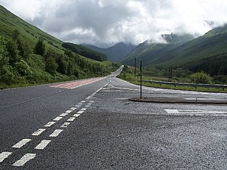
The A83 is a major road in the south of Argyll and Bute, Scotland, running from Tarbet, on the western shore of Loch Lomond, where it splits from the A82, to Campbeltown at the southern end of the Kintyre peninsula. The road is best known for its section across the Rest and be Thankful pass through the Arrochar Alps between the heads of Loch Long and Loch Fyne.
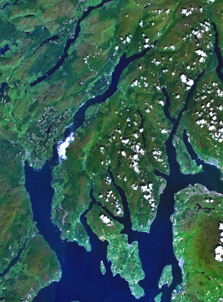
Cowal is a rugged peninsula in Argyll and Bute, on the west coast of Scotland. It is connected to the mainland to the north, and is bounded by Loch Fyne to the west, by Loch Long and the Firth of Clyde to the east, and by the Kyles of Bute to the south.

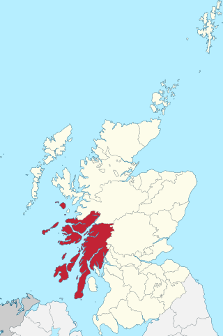
Loch Fyne, is a sea loch off the Firth of Clyde and forms part of the coast of the Cowal Peninsula. Located on the west coast of Argyll and Bute, west of Scotland. It extends 65 kilometres (40 mi) inland from the Sound of Bute, making it the longest of the sea lochs in Scotland. It is connected to the Sound of Jura by the Crinan Canal. Although there is no evidence that grapes have grown there, the title is probably honorific, indicating that the river, Abhainn Fìne, was a well-respected river.

The Arrochar Alps are a group of mountains located around the heads of Loch Long, Loch Fyne, and Loch Goil. They are part of the Grampian mountains range, which stretch across Scotland. The villages of Arrochar and Lochgoilhead are the nearest settlements. Many of the mountains are located on the Cowal Peninsula in Argyll and Bute, west of Scotland.

Tarbert is a village in the west of Scotland, in the Argyll and Bute council area. It is built at the head of an inlet of Loch Fyne called East Loch Tarbert, on a narrow isthmus which connects Kintyre to the south with Knapdale to the north and separates East Loch Tarbert from the much longer West Loch Tarbert. Tarbert had a recorded population of 1,338 in the 2001 Census.
Beinn an Lochain is a mountain in the Arrochar Alps on the Cowal Peninsula, in western Scotland and is a Corbett at 901.7 metres (2,958 ft). Beinn an Lochain is situated within the Argyll Forest Park which is itself within the Loch Lomond and the Trossachs National Park.

Strachur and Strathlachlan are united parishes located on the Cowal Peninsula, in Argyll and Bute, west of Scotland. Strachur is a small village on the eastern coast of Loch Fyne.

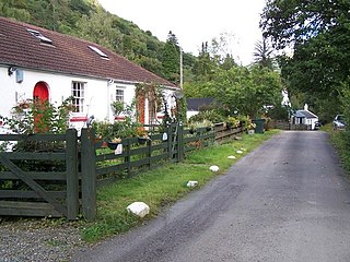
Cairndow is a coastal hamlet on the Cowal Peninsula, in Argyll and Bute, Scottish Highlands. The town lies between the A83 road and the head of Loch Fyne.

Loch Eck is a freshwater loch located on the Cowal Peninsula, north of Dunoon, in Argyll and Bute, west of Scotland. It is seven miles long. It is oriented in a north-south direction. Its main inflow, at the northern end, is the River Cur, and its main outflow, at the southern end, is the River Eachaig, which meanders somewhat within the confines of the broad strath before flowing into the head of Holy Loch, about 5 km further south.
The A815 is a major road located on the Cowal peninsula, in Argyll and Bute, Scotland. It runs for about 35.7 miles (57.5 km) from the A83, near Cairndow, in the north to Toward in the south. It passes beside three lochs, while its final stretch is along the Firth of Clyde.

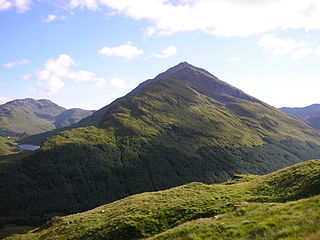
Beinn Bhuidhe is a mountain near the head of Loch Fyne in Argyll in the Scottish Highlands. It is a Munro with a height of 948 metres (3,110 ft).

Glen Shira is a glen in Argyll and Bute, west of Scotland, at the northern end of Loch Fyne, just to the north of Inveraray. It is a Special Area of Conservation within the UK, bordered by Beinn Bhuidhe on the Glen Fyne side.

River Shira is the river that runs for about 7 miles through Glen Shira, in Argyll and Bute, west of Scotland. Originating to the north-east at 350 metres (1,150 ft) altitude, near the start of the River Fyne.
Glenbranter is a hamlet and former estate, once owned by Sir Harry Lauder, on the northwest shore of Loch Eck in the Argyll Forest Park, on the Cowal Peninsula, in Argyll and Bute, West of Scotland.

Ardkinglas House is a Category A listed country house on the Ardkinglas Estate in Argyll, Scotland. The estate lies on the eastern shore of Loch Fyne, and the house is located close to the village of Cairndow. Dating back to the 14th century and originally a Campbell property, the estate now covers more than 12,000 acres (4,900 ha) of rolling hills and landscaped parkland. The centre of the estate was Ardkinglas Castle until this was replaced by a new house in the 18th century. This house was itself replaced by the present Ardkinglas House in the early 20th century, designed by Sir Robert Lorimer for Sir Andrew Noble. It remains the property of the Noble family, and is open to the public on a limited basis. The woodland gardens are open all year round.

Strachur Bay is a coastal embayment, on a 114° orientation, on the eastern coast of the longest sea loch in Scotland, Loch Fyne located in Argyll and Bute, on the west coast of Scotland. Strachur Bay provides good anchorage, for small vessels, when the wind is from the northeast and southeast.

The Shira Hydro-Electric Scheme is a project initiated by the North of Scotland Hydro-Electric Board to use the waters of the River Shira, the River Fyne and other small streams to generate hydroelectricity. It is located between Loch Fyne and Loch Awe in Argyll and Bute, western Scotland. It consists of three power stations and three impounding dams.
