River Ecclesbourne

Last updated

River Ecclesbourne
River Ecclesbourne - geograph.org.uk - 225386.jpg
Derbyshire UK relief location map.jpg
Red pog.svg
Confluence with Derwent in Derbyshire
Location
Country England
Counties Derbyshire
Physical characteristics
Source 
  location Wirksworth, Derbyshire
Mouth Confluence with the Derwent
  location
Duffield, Derbyshire
  coordinates
52°59′5″N1°28′48″W / 52.98472°N 1.48000°W / 52.98472; -1.48000
Length15 km (9.3 mi)
Basin size60 km2 (23 sq mi)
Discharge 
  location Duffield [1]
  average0.63 m3/s (22 cu ft/s)
Basin features
Tributaries 
  leftFranker Brook
  rightAlton Brook, Holm Brook, Sherbourne Brook
Progression : Ecclesbourne—DerwentTrentHumberNorth Sea

The River Ecclesbourne is a small river in Derbyshire, England, which starts in the upper part of the town of Wirksworth, flows for 9 miles to Duffield, [2] and then enters the River Derwent just outside the village.

Contents

Course

The River Ecclesbourne's source is in the town of Wirksworth. This is also where the Ecclesbourne Valley Railway, which is named after the river and follows it for its entire length, begins. The start of the river is located between Steeple Grange and Sough Lane. The river's two main headwaters come from Steeple Grange, below Bolehill, and the fields below the National Stone Centre, Ravenstor. The main source is about 100 metres down the railway tracks from Ravenstor railway station, where the Meerbrook Sough Mine area lies. The Meerbrook Sough drained water from the nearby quarries and led them in a tunnel to Whatstandwell where the excess water from the Sough joined the River Derwent towards Ambergate. The source of the Ecclesbourne contributed to the water powering the Meerbrook Sough. The Ecclesbourne flows mostly underground through the area of the Sough, but momentarily appears above ground in several places, near Ecclesbourne Cottages at the bottom of Sough Lane, in a shallow ditch next to the railway (now piped) and also near the bottom of Fanny Shaws Park, again near the main railway track. Part of the main headwaters of the Ecclesbourne flowed past the rectangular Sough Reservoir, which transported water up to the quarries around Wirksworth. This reservoir was located at the bottom left area of Fanny Shaws Park. The Meerbrook Sough Engine House was built in the middle of the Sough area and powered the waterworks of the Sough and made materials for the quarries. Below Fanny Shaws Park and skatepark the Ecclesbourne leaves the Sough area and goes underground and reappears in the Hannages further down the railway tracks, where it powered the mills at the bottom of Wirksworth. The housing estate of Spring Close has recently been built over the area of the Meerbrook Sough; the Engine House still remains in its original place, but has recently been renovated into a house.

After leaving Wirksworth the River Ecclesbourne is now a fairly large river. It flows slowly through the fields, collecting smaller streams as it goes (among them the Alton Brook and Holm Brook), to its next port of call, the village of Idridgehay. Further down, the Ecclesbourne flows through Turnditch. After leaving Turnditch the Ecclesbourne increases in volume and speed. In some areas the river is piped underground to reduce the risk of flooding, but this rarely happens any more.

A few miles beyond Turnditch the river enters the village of Duffield. The Ecclesbourne School, the village's secondary school, is built on its banks in the village centre. The Ecclesbourne then flows out of Duffield and leaves the railway after flowing underneath its tracks. It reappears and flows through a few more fields before joining the River Derwent, which has just come down from Milford and Belper. At the confluence where the Ecclesbourne ends it is about 10 metres wide. The area around the confluence is popular with visitors and a good area for angling. After the river has met the Derwent, the railway line joins the main line to Derby.

Wildlife and conservation

The River Ecclesbourne is a popular fishing river, known for producing good-quality fish, especially in its lower reaches. It supports a population of brown trout.

Species of conservation interest found along the Ecclesbourne include white-clawed crayfish, kingfisher, otter and water vole. Threats include pollution, weirs that restrict fish migration, and invasive Himalayan balsam. The river is one of 25 river catchments chosen by Defra for a Pilot Catchment Project, with the aim of encouraging co-operation between various agencies and interested parties to improve water quality, as part of the UK's commitment to the EU Water Framework Directive. [2]

Related Research Articles

<span class="mw-page-title-main">River Derwent, Derbyshire</span> River in Derbyshire, England

The Derwent is a river in Derbyshire, England. It is 50 miles (80 km) long and is a tributary of the River Trent, which it joins south of Derby. Throughout its course, the river mostly flows through the Peak District and its foothills.

<span class="mw-page-title-main">Wirksworth</span> Market town in Derbyshire, England

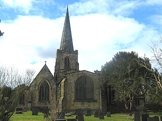
Wirksworth is a market town in the Derbyshire Dales district of Derbyshire, England. Its population of 4,904 in the 2021 census was estimated at 5,220 in 2023. Wirksworth contains the source of the River Ecclesbourne. The town was granted a market charter by Edward I in 1306 and still holds a market on Tuesdays in the Memorial Gardens. The parish church of St Mary's is thought to date from 653. The town developed as a centre for lead mining and stone quarrying. Many lead mines were owned by the Gell family of nearby Hopton Hall.

<span class="mw-page-title-main">Duffield, Derbyshire</span> Human settlement in England

Duffield is a village in the Amber Valley district of Derbyshire, 5 miles (8.0 km) north of Derby. It is centred on the western bank of the River Derwent at the mouth of the River Ecclesbourne. It is within the Derwent Valley Mills World Heritage Area and the southern foothills of the Pennines.

<span class="mw-page-title-main">Cromford</span> Village in Derbyshire, England

Cromford is a village and civil parish in Derbyshire, England, in the valley of the River Derwent between Wirksworth and Matlock. It is 17 miles (27 km) north of Derby, 2 miles (3.2 km) south of Matlock and 1 mile (1.6 km) south of Matlock Bath. It is first mentioned in the 11th-century Domesday Book as Crumforde, a berewick of Wirksworth, and this remained the case throughout the Middle Ages. The population at the 2011 Census was 1,433. It is principally known for its historical connection with Richard Arkwright and the nearby Cromford Mill, which he built outside the village in 1771. Cromford is in the Derwent Valley Mills World Heritage Site.

<span class="mw-page-title-main">Derbyshire lead mining history</span> History of lead mining in Derbyshire

This article details some of the history of lead mining in Derbyshire, England.

<span class="mw-page-title-main">Cromford and High Peak Railway</span> Early British railway company (1833–1871)

The Cromford and High Peak Railway (C&HPR) was a standard-gauge line between the Cromford Canal wharf at High Peak Junction and the Peak Forest Canal at Whaley Bridge. The railway, which was completed in 1831, was built to carry minerals and goods through the hilly rural terrain of the Peak District within Derbyshire, England. The route was marked by a number of roped worked inclines. Due to falling traffic, the entire railway was closed by 1967.

<span class="mw-page-title-main">Ecclesbourne Valley Railway</span> Heritage railway in England

The Ecclesbourne Valley Railway is a 9-mile (14.5 km) long heritage railway in Derbyshire. The headquarters of the railway centre on Wirksworth station, and services operate in both directions between Wirksworth and Duffield and from Wirksworth to Ravenstor.

<span class="mw-page-title-main">Cromford Canal</span>

The Cromford Canal ran 14.5 miles from Cromford to the Erewash Canal in Derbyshire, England with a branch to Pinxton. Built by William Jessop with the assistance of Benjamin Outram, its alignment included four tunnels and 14 locks.

<span class="mw-page-title-main">Derwent Valley line</span> Matlock to Derby railway line

The Derwent Valley line is a railway line from Derby to Matlock in Derbyshire.

<span class="mw-page-title-main">Duffield railway station</span> Railway station in Derbyshire, England

Duffield railway station serves the village of Duffield in Derbyshire, England. The station is located on the Midland Main Line from Derby to Leeds, 133 miles 8 chains (214.2 km) north of London St Pancras. It is also a junction with the former branch line to Wirksworth, which is now operated as the Ecclesbourne Valley heritage railway.

<span class="mw-page-title-main">Sough</span>

A sough is an underground channel for draining water.

<span class="mw-page-title-main">Middleton-by-Wirksworth</span> Village and civil parish in Derbyshire Dales, Derbyshire, England

Middleton or Middleton-by-Wirksworth is an upland village and civil parish lying approximately one mile NNW of Wirksworth, Derbyshire, England. Middleton was, in 1086, a berewick of the town and manor of Wirksworth. Middleton was formerly known for its lead mines and high quality limestone quarries, including the underground quarry site at Middleton Mine. The Middleton Mine networks underground for approximately 25 miles (40 km) with tunnels on three different levels running under Middleton Moor to the Hopton Wood quarry works at the other side of the hill below Ryder Point Works’. Part of the tunnel collapsed in the 1970s leaving a noticeable depression in the ground above on the eastern side of Middleton Moor. The population of the parish as taken at the 2011 Census was 775.

<span class="mw-page-title-main">Shottle and Postern</span> Civil parish in Derbyshire, England

Shottle and Postern is a civil parish within the Amber Valley district, which is in the county of Derbyshire, England. Sparsely built up with much rural expanse, its population was 270 residents in the 2021 census. The parish is 120 miles (190 km) north west of London, 9 miles (14 km) north west of the county town of Derby, and 2+34 miles (4.4 km) equidistant of the nearest market towns of Belper and Wirksworth. It shares a boundary with the parishes of Alderwasley, Ashleyhay, Belper, Hazelwood, Idridgehay and Alton, Turnditch and Windley.

<span class="mw-page-title-main">Shottle railway station</span> Former railway station in England

Shottle railway station is the second intermediate station on the former Midland Railway branch line to the small town of Wirksworth in Derbyshire. The line is off the Midland Main Line at Duffield railway station, the first being Hazelwood.

<span class="mw-page-title-main">Wirksworth railway station</span> Railway station in Derbyshire, England

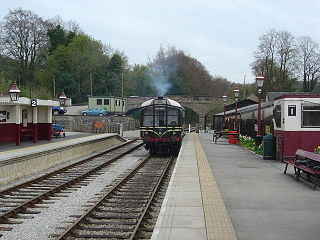
Wirksworth Railway Station is a heritage railway station that serves the town of Wirksworth in Derbyshire. It was the former terminus of the Midland Railway Wirksworth branch line, leaving the Midland Main Line at Duffield. The line was reopened as the Ecclesbourne Valley Railway.

<span class="mw-page-title-main">Cromford Mill</span> Grade I listed mill in Derbyshire, England

Cromford Mill is the world's first water-powered cotton spinning mill, developed by Richard Arkwright in 1771 in Cromford, Derbyshire, England. The mill structure is classified as a Grade I listed building. It is now the centrepiece of the Derwent Valley Mills UNESCO World Heritage Site, and is a multi-use visitor centre with shops, galleries, restaurants and cafes.

<span class="mw-page-title-main">Idridgehay railway station</span> Former railway station in England

Idridgehay railway station is an intermediate station on the former Midland Railway branch line to the town of Wirksworth in Derbyshire. Off the Midland Main Line at Duffield, the line has been reopened as the Ecclesbourne Valley Railway, and Idridgehay station was reopened on 8 March 2008.

<span class="mw-page-title-main">Ravenstor railway station</span>

Ravenstor railway station is a Heritage railway station at the northernmost limit of the Ecclesbourne Valley Railway, Wirksworth, Derbyshire.

<span class="mw-page-title-main">Hazelwood railway station</span> Former railway station in Derbyshire, England

Hazelwood Railway Station is a disused railway station on the Wirksworth branch of the Midland Railway. It served the village of Hazelwood.

<span class="mw-page-title-main">Idridgehay</span> Human settlement in England

Idridgehay is a village in the civil parish of Idridgehay and Alton, in the Amber Valley district of Derbyshire, England.

References

  1. "28055 - Ecclesbourne at Duffield". The National River Flow Archive. Centre for Ecology & Hydrology. Retrieved 10 February 2013.
  2. 1 2 Turley, Heather (2012). "The Ecclesbourne: Going with the flow". Wild Derbyshire. Derbyshire Wildlife Trust. Winter 2012/Spring 2013: 14.