
The River Flit is a short river in Bedfordshire, England. [1] Its name is not ancient, but rather a back formation from Flitton which originally meant that the river was spelt with as Flitt rather than Flit. [2]
The River Flit is a short river in Bedfordshire, England. [1] Its name is not ancient, but rather a back formation from Flitton which originally meant that the river was spelt with as Flitt rather than Flit. [2]
The river rises as a small pool beneath Carters Hill, a few metres to the east of the M1 motorway and just to the east of the village of Chalton, Bedfordshire.
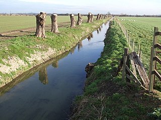
Flowing north, it reaches Flitwick, then north east past Greenfield and Flitton, then through Clophill, Chicksands, and Shefford, where it is joined by the River Hit, then past Stanford, before meeting the River Ivel at Langford. [3]
Below its junction with the River Hit, the 5 kilometres (3.1 mi) of its course was largely incorporated into a canal, known as the Shefford Canal or River Ivel Navigation. Completed in 1823, the canal connected Shefford with the North Sea allowing barges of coal to be brought to the town. The canal fell into decline over the following decades and in 1876 a dam was installed on the Ivel at Sandy, closing the Shefford section for good. [4] Today, sections of the canal near Shefford are dry or have been filled in. [5]

Flitwick, is a town and civil parish in Bedfordshire, England. It is mentioned in the Domesday Book of 1086 as "a hamlet on the River Flitt". The spelling Flytwyk appears in 1381.

Biggleswade is a market town and civil parish in Central Bedfordshire, part of the ceremonial county of Bedfordshire, England. It lies on the River Ivel, 11 miles (18 km) south-east of Bedford. Its estimated population was 20,200 in mid-2017, its growth encouraged by good road and rail links to London. The King's Reach development, begun in 2010, will provide 2,000 new homes to the east of the town.

The River Ivel is a north-flowing river in the western part of east of England. It is primarily in Bedfordshire; it is a tributary of the River Great Ouse and has sources including in the Barton Hills.
The River Ouzel, also known as the River Lovat, is a river in England, and a tributary of the River Great Ouse. It rises in the Chiltern Hills and flows 20 miles north to join the Ouse at Newport Pagnell.

Campton is a village in the Central Bedfordshire district of Bedfordshire, England. It is part of the civil parish of Campton and Chicksands with the nearby Chicksands. It is about 9 miles (14 km) south of Bedford, and is about 9 miles (14 km) north-west from Letchworth and sits on a tributary of the River Ivel. It is just to the west of Shefford. The 13th century Church of All Saints is in the centre of the village.

Mid Bedfordshire is a constituency represented in the House of Commons of the UK Parliament since 2005 by Nadine Dorries, of the Conservative Party. Apart from four early years, the constituency has returned a Conservative since its creation in 1918.

North East Bedfordshire is a constituency represented in the House of Commons of the Parliament of the United Kingdom since 2019 by Richard Fuller, of the Conservative Party.

Shefford is a town and civil parish located in the Central Bedfordshire district of Bedfordshire, England. At the 2001 census it had a population of 4,928, and was estimated to have grown to 5,770 by 2007. The population at the 2011 Census had risen to 5,881.

Astwick is a hamlet and civil parish in the Central Bedfordshire district of the county of Bedfordshire, England about 12.5 miles (20 km) south-east of the county town of Bedford. Its population is included within Stotfold civil parish.

Blunham is a village and civil parish in the Central Bedfordshire district of Bedfordshire, England, about 8 miles (13 km) east of Bedford. At the 2011 census date its population was 946. The River Ivel forms the parish's eastern boundary in places and the River Great Ouse its western and northern boundaries. The village is just over 0.6 miles (1 km) to the west of the A1 road, and Route 51 of the National Cycle Network passes to the south.

Arlesey railway station serves the town of Arlesey in Bedfordshire, England. It is 37 miles 3 chains (59.61 km) from London King's Cross on the East Coast Main Line. Arlesey is managed by Great Northern, but from December 2019 all services to the station have been operated by Thameslink, due to significant rebranding across their network.
Stanford is a hamlet in the Central Bedfordshire district of the county of Bedfordshire, England about 8.5 miles (14 km) south-east of the county town of Bedford. Its population is included within Southill civil parish.

The A507 is an A-class road in England, linking the M1 motorway near Milton Keynes to the A10 at Buntingford.

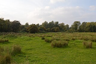
The Riddy is an 8.4 hectare flood meadow and Local Nature Reserve located in Sandy, Bedfordshire, United Kingdom, bordering the River Ivel. Owned by Sandy Town Council but managed by both the Wildlife Trust for Bedfordshire, Cambridgeshire and Northamptonshire and Bedfordshire Rural Communities Charity, the 7.7 hectares site gains its name from a small stream which flows through the eastern end of the reserve. The different habitats in the Riddy support a diverse range of species, including a multiplicity of grasses and flowering plants in the meadows, aquatic plants and water voles which inhabit the ditches, ponds and stream, and birds which feed and hunt across the reserve.
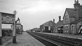
Blunham was a railway station on the Varsity Line which served the small village of the same name in Bedfordshire. Opened in 1862, the station was located in a rural area and saw little passenger traffic; it closed together with the line in 1968.

Shefford Town & Campton Football Club is an English football club based in the town of Shefford, Bedfordshire. The team plays its home matches at Shefford Sports Club on Hitchin Road in Shefford and at Campton Playing Fields, Rectory Road in Campton. The club is competing at the 10th tier of the English football league system in the Spartan South Midlands Football League Division One. The club also has a reserve side competing in Division 1 of the Bedfordshire County Football League and an A team competing in Division 3 of the same competition.
(Greensand Cycleway) Signs for this route appeared in the first half of 2014. It covers roughly 40 miles (64 km), using minor roads and runs roughly in parallel with its sister walk, the Greensand Ridge Walk. The route traverses Bedfordshire, making brief forays into the neighbouring counties of Cambridgeshire and Buckinghamshire. Its southern endpoint is at Leighton Buzzard and the route runs north-east to Sandy. The waymarker for this route is simply Greensand Cycleway and the depiction of a bicycle on a brown background. There are some smaller, circular waymarkers employed to ensure continuity of the route for cyclists.
Henlow Common and Langford Meadows is a 18.4-hectare (45-acre) Local Nature Reserve on the west side of the River Ivel in Langford. It is owned and managed by Central Bedfordshire Council. Henlow Common is common land.
| Wikimedia Commons has media related to River Flit . |
Coordinates: 52°02′19″N0°20′50″W / 52.03855°N 0.34727°W
| | This Bedfordshire location article is a stub. You can help Wikipedia by expanding it. |