Durham, also known as the City of Durham, is a cathedral city and civil parish in the district and county of Durham, England. The city is on the banks of the River Wear.

Bishop Auckland is a market town and civil parish in County Durham, north east England, 12 miles (19 km) northwest of Darlington, 12 miles (19 km) southwest of Durham and 5 miles (8 km) southeast of Crook, at the confluence of the River Wear with its tributary the River Gaunless. At the 2001 census, Bishop Auckland had a population of 24,392.
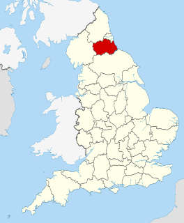
County Durham is a ceremonial county in North East England. The county town is the city of Durham. The ceremonial county spawned from the historic County Palatine of Durham in 1853. The largest settlement is Darlington, followed by Hartlepool and Stockton-on-Tees. The county borders are shared with multiple counties: Northumberland as well as Tyne and Wear to the north, North Yorkshire to the south and Cumbria to the west.

Butterknowle is a village in Teesdale, County Durham, England. Butterknowle is situated between the market towns of Bishop Auckland and Barnard Castle. It has an attractive rural setting within the Gaunless Valley, overlooked by the gorse-covered Cockfield Fell. The fell itself is a scheduled ancient monument, containing evidence of Roman settlements and a medieval coal mine (Vavasours), thought to be the earliest inland colliery recorded.
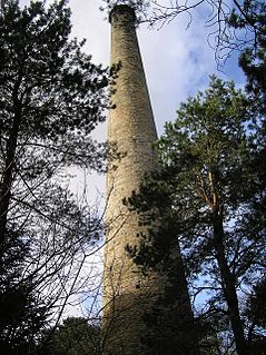
Copley is a village of roughly 400 inhabitants in County Durham, in England. It is situated 9 miles to the west of Bishop Auckland, and 6 miles from the historic market town of Barnard Castle. It has an attractive rural setting close to the North Pennines area of outstanding natural beauty (AONB). The lower part of the village by the River Gaunless still retains the original chimney and some of the buildings from the old Gaunless Valley Lead Mill.

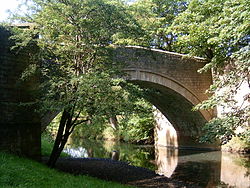
Ramshaw is a village in County Durham, in England. It is situated to the west of Bishop Auckland. Ramshaw was originally a mining village and is home to one restaurants, the Bridge Inn. The River Gaunless runs through Ramshaw. The name Gaunless itself is of later Norse origin, meaning useless. It is believed that this derives from the river's inability to power a mill, sustain fish or create fertile floodplains. The bridge connecting Ramshaw with neighbouring village Evenwood is between 300 and 500 years old. Ramshaw has a caravan site.
Evenwood is a village in County Durham, in England. It is situated to the south west of Bishop Auckland. It is in the civil parish of Evenwood and Barony, which has a population of 2,534 falling to 2,455 at the 2011 Census.

Appersett is a hamlet in the Yorkshire Dales in the Richmondshire district of North Yorkshire, England one mile (1.6 km) west of Hawes. It lies on the A684 road and an unclassified road runs alongside Widdale Beck to connect with the B6255 road between Hawes and Ingleton.

The South Durham & Lancashire Union Railway (SD&LUR) built a railway line linking the Stockton & Darlington Railway near Bishop Auckland with the Lancaster and Carlisle Railway at Tebay, via Barnard Castle, Stainmore Summit and Kirkby Stephen. The line opened in 1861 and became known as the Stainmore Line.
The Stanhope and Tyne Railway was an early British mineral railway, that ran from Stanhope in County Durham, to South Shields at the mouth of the River Tyne. The object was to convey limestone from Stanhope and coal from West Consett and elsewhere to the Tyne, and to local consumers. Passengers were later carried on parts of the line.

OK Motor Services was a bus company operating in County Durham from 1912 until the 1990s when purchased by the Go-Ahead Group. Following rationalisation and rebranding, the OK livery disappeared from the roads as services were integrated with Go North East.

The River Wear in North East England rises in the Pennines and flows eastwards, mostly through County Durham to the North Sea in the City of Sunderland. At 60 mi (97 km) long, it is one of the region's longest rivers, wends in a steep valley through the cathedral city of Durham and gives its name to Weardale in its upper reach and Wearside by its mouth.
The Derwent Valley Railway was a branch railway in County Durham, England. Built by the North Eastern Railway, it ran from Swalwell to Blackhill via five intermediate stations, and onwards to Consett.
Smardale is a small village in Cumbria, England, in the civil parish of Waitby.

Gaunless Viaduct, also known as the 'Lands Viaduct', was a railway viaduct in County Durham. It was designed by Thomas Bouch to carry the South Durham and Lancashire Union Railway between Bishop Auckland and Barnard Castle over the River Gaunless at Lands, also crossing the Haggerleases branch of the railway to Butterknowle.
The Lanchester Valley Railway was an English railway line that was developed by the North Eastern Railway to run between Durham to Consett. Extending 12 miles (19 km) along the valley of the River Browney, it opened on 1 September 1862. Closed under the Beeching Axe, it has been redeveloped by Durham County Council as a foot and cycle path as the Lanchester Valley Railway Path.

The Durham to Bishop Auckland Line was a railway line originally built by the North Eastern Railway (NER) to provide rail transport access to coal mines in West County Durham. It closed under the Beeching Axe to passenger traffic in May 1964, and freight in 1968. Today it forms the major part of the 9 miles (14 km) Brandon to Bishop Auckland rail trail.