
Cumbria is a ceremonial and non-metropolitan county in North West England. The county and Cumbria County Council, its local government, came into existence in 1974 after the passage of the Local Government Act 1972. Cumbria's county town is Carlisle, in the north of the county; the only other major urban area is Barrow-in-Furness on the south-western tip of the county.
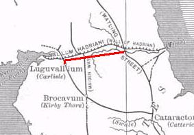
The Stanegate, was an important Roman road built in what is now northern England. It linked two forts that guarded important river crossings: Corstopitum (Corbridge) on the River Tyne in the east, and situated on Dere Street, and Luguvalium (Carlisle) on the River Eden in the west. The Stanegate ran through the natural gap formed by the valleys of the River Tyne in Northumberland and the River Irthing in Cumbria. It predated Hadrian's Wall by several decades; the Wall would later follow a similar route, slightly to the north.
Cumbric was a variety of the Common Brittonic language spoken during the Early Middle Ages in the Hen Ogledd or "Old North" in what is now Northern England and southern Lowland Scotland. It was closely related to Old Welsh and the other Brittonic languages. Place name evidence suggests Cumbric may also have been spoken as far south as Pendle and the Yorkshire Dales. The prevailing view is that it became extinct in the 12th century, after the incorporation of the semi-independent Kingdom of Strathclyde into the Kingdom of Scotland. However, that is only in a primary and Official capacity where it is claimed to have survived until the 1800's when the last speaker died.
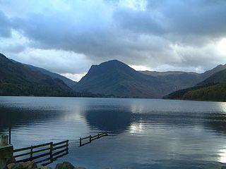
Buttermere is a lake in the Lake District in North West England. The adjacent village of Buttermere takes its name from the lake. Historically in Cumberland, the lake is now within the county of Cumbria. Owned by the National Trust, it forms part of its Buttermere and Ennerdale property.
The River Eden is a river that flows through the Eden District of Cumbria, England, on its way to the Solway Firth.

The River Irthing is a river in Cumbria, England and a major tributary of the River Eden. The name is recorded as Ard or Arden in early references. For the first 15 miles of its course it defines the border between Northumberland and Cumbria.

Ravenglass is a small coastal village and natural harbour in Cumbria, England, roughly halfway between Barrow-in-Furness and Whitehaven. Historically in Cumberland, it is the only coastal town in the Lake District National Park. It is located at the estuary of three rivers: the Esk, Mite and Irt.

Banna, now known as Birdoswald Roman Fort, was a fort, towards the western end of Hadrian's Wall, in the Roman province of Britannia. Today the site is occupied by a former farm called Birdoswald. As of 2005, it is the only site on Hadrian's Wall at which significant occupation in the post-Roman period has been proven, and it is subject to a long-term archaeological programme under the directorship of Tony Wilmott.
Cumbrian toponymy refers to the study of place names in Cumbria, a county in North West England, and as a result of the spread of the ancient Cumbric language, further parts of northern England and the Southern Uplands of Scotland.
The history of Cumbria as a county of England begins with the Local Government Act 1972. Its territory and constituent parts however have a long history under various other administrative and historic units of governance. Cumbria is an upland, coastal and rural area, with a history of invasions, migration and settlement, as well as battles and skirmishes between the English and the Scots.

Burtholme refers to any of a civil parish in Cumbria, England, a hamlet within that parish or a family name originally linked to the place. It also appears in Burtholme Beck, which marks a significant point on Hadrian's Wall.

The Poltross Burn is a tributary of the River Irthing. The burn rises on Denton Fell and flows north-east, joining the Irthing at Gilsland. The well-preserved Roman Milecastle 48, a feature of Hadrian's Wall once known locally as The King's Stables, stands on the west bank. It is signposted as Poltross Burn Milecastle, and adjoins the south side of the railway embankment in Gilsland. A 19th-century watermill within the village used the burn as a source of power to grind corn.

Walton is a village and civil parish in the far north of Cumbria, England. It is located 10 miles (16 km) from Carlisle and is about 2 miles (3 km) north of Brampton, on the north bank of the River Irthing. Nearby villages include Newtown, Banks and Lanercost.

Camboglanna was a Roman fort. It was the twelfth fort on Hadrian's Wall counting from the east, between Banna (Birdoswald) to the east and Uxelodunum (Stanwix) to the west. It was almost 7 miles (11 km) west of Birdoswald, on a high bluff commanding the Cambeck Valley. It guarded an important approach to the Wall and also watched the east bank of the Cambeck against raiders from the Bewcastle area. The site was drastically levelled in 1791 when the gardens of Castlesteads House were laid over it. The name "Camboglanna" is believed to mean "Crook Bank", or "Bent Valley" because it overlooks a bend in the river Irthing; the name is Brythonic, made of cambo- "curved, bent, crooked" and glanna "steep bank, stream/river side, valley with a stream".

Hadrian's Wall, also known as the Roman Wall, Picts' Wall, or Vallum Hadriani in Latin, is a former defensive fortification of the Roman province of Britannia, begun in AD 122 in the reign of the emperor Hadrian. It ran from the banks of the River Tyne near the North Sea to the Solway Firth on the Irish Sea, and allowed the Roman Empire to project power some distance to the north, into the lands of the northern Ancient Britons, including the Picts.

Verterae was a Roman fort in the modern-day village of Brough, Cumbria, England. Occupied between the 1st and 5th centuries AD, it protected a key Roman road in the north of England. In the 11th century, Brough Castle was built on part of the site by the Normans. Archaeologists explored the remains during the 20th century, and it is now protected under UK law.
The history of medieval Cumbria has several points of interest. The region's status as a borderland coping with 400 years of warfare is one. The attitude of the English central government, at once uninterested and deeply interested, is another. As a border region, of geopolitical importance, Cumbria changed hands between the Angles, Norse, Strathclyde Brythons, Picts, Normans, Scots and English; and the emergence of the modern county is also worthy of study.
Roman Cumbria was an area that lay on the north-west frontier of Roman Britain, and, indeed, of the Roman Empire itself.. Interest in the Roman occupation of the region lies in this frontier aspect - why did the Romans choose to occupy the north-west of England; why build a solid barrier in the north of the region ; why was the region so heavily militarised; to what extent were the native inhabitants 'Romanised' compared to their compatriots in southern England?

Waterhead is a civil parish in Carlisle district, Cumbria, England. At the 2011 census it had a population of 130.
