
The Lake District, also known as the Lakes or Lakeland, is a mountainous region in North West England. A popular holiday destination, it is famous for its lakes, forests and mountains, and its associations with William Wordsworth and other Lake Poets and also with Beatrix Potter and John Ruskin. The Lake District National Park was established in 1951 and covers an area of 2,362 square kilometres (912 sq mi). It was designated a UNESCO World Heritage Site in 2017.

The Mackenzie River is a river in the Canadian boreal forest. It forms, along with the Slave, Peace, and Finlay, the longest river system in Canada, and includes the second largest drainage basin of any North American river after the Mississippi.

The Kobuk River is a river located in the Arctic region of northwestern Alaska in the United States. It is approximately 280 miles (451 km) long. Draining a basin with an area of 12,300 square miles (32,000 km2), the Kobuk River is among the largest rivers in northwest Alaska with widths of up to 1500 feet and flow at a speed of 3–5 miles per hour in its lower and middle reaches. The average elevation for the Kobuk River Basin is 1,300 feet (400 m) above sea level, ranging from near sea level to 11,400 feet. Topography includes low, rolling mountains, plains and lowlands, moderately high rugged mountainous land, and some gently sloped plateaus and highlands. The river contains an exceptional population of sheefish, a large predatory whitefish within the salmon family, found throughout the Arctic that spawns in the river's upper reaches during the autumn. A portion of the vast Western Arctic Caribou Herd utilize the Kobuk river valley as winter range.

The Feather River is the principal tributary of the Sacramento River, in the Sacramento Valley of Northern California. The river's main stem is about 73 miles (117 km) long. Its length to its most distant headwater tributary is just over 210 miles (340 km). The main stem Feather River begins in Lake Oroville, where its four long tributary forks join—the South Fork, Middle Fork, North Fork, and West Branch Feather Rivers. These and other tributaries drain part of the northern Sierra Nevada, and the extreme southern Cascades, as well as a small portion of the Sacramento Valley. The total drainage basin is about 6,200 square miles (16,000 km2), with approximately 3,604 square miles (9,330 km2) above Lake Oroville.
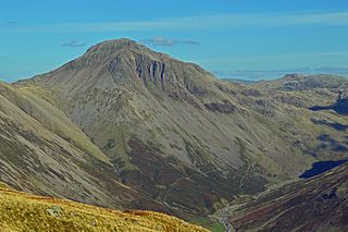
Great Gable is a mountain in the Lake District, United Kingdom. It is named after its appearance as a pyramid from Wasdale, though it is dome-shaped from most other directions. It is one of the most popular of the Lakeland fells, and there are many different routes to the summit. Great Gable is linked by the high pass of Windy Gap to its smaller sister hill, Green Gable, and by the lower pass of Beck Head to its western neighbour, Kirk Fell.

Aira Force is a waterfall in the English Lake District, in the civil parish of Matterdale and the county of Cumbria. The site of the waterfall is owned by the National Trust.

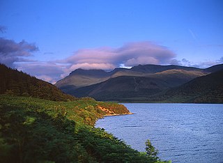
Ennerdale Water is the most westerly lake in the Lake District National Park in Cumbria, England. It is a glacial lake, with a maximum depth of 150 feet, and is ½ mile to a mile wide and 2½ miles long.
Wasdale is a valley and civil parish in the western part of the Lake District National Park in Cumbria, England. The River Irt flows through the valley to its estuary at Ravenglass. A large part of the main valley floor is occupied by Wastwater, the deepest lake in England. The population of Wasdale was only minimal and, from the 2011 Census is included in the parish of Gosforth.

New Melones Dam is an earth and rock filled embankment dam on the Stanislaus River, about 5 miles (8.0 km) west of Jamestown, California, United States, on the border of Calaveras County and Tuolumne County. The water impounded by the 625-foot (191 m)-tall dam forms New Melones Lake, California's fourth largest reservoir, in the foothills of the Sierra Nevada east of the San Joaquin Valley. The dam serves mainly for irrigation water supply, and also provides hydropower generation, flood control, and recreation benefits.
Buttermere and Ennerdale is a National Trust property located in the Lake District of Cumbria, England.

Cumbrian toponymy refers to the study of place names in Cumbria, a county in North West England, and as a result of the spread of the ancient Cumbric language, further parts of northern England and the Southern Uplands of Scotland.
The River Bleng is a tributary of the River Irt in the county of Cumbria in northern England.

The River Eea is a small river in the Lake District, Cumbria, England running through the Furness region, which until 1974 was part of Lancashire. It is a relatively short system that arises from numerous small becks and streams throughout the Cartmel Valley. Its course is approximately 10 km long and its mouth is on Sand Gate marshes near Flookburgh, between Barrow and Kendal. It principally flows in a south-westerly direction.

The River Gelt is a river in Cumbria, England and a tributary of the River Irthing.

The River Ehen is a river in Cumbria, England.

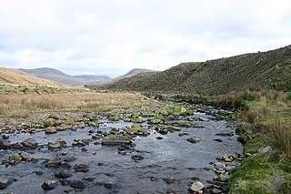
Ennerdale is a valley in Cumbria, England. Ennerdale Water, fed by the River Liza, is the most westerly lake in the Lake District National Park.

Ennerdale Bridge is a hamlet in the county of Cumbria, England. It is in the civil parish of Ennerdale and Kinniside. It had a total population taken at the 2011 census of 220.

The Taltson River is a roughly 500 km (310 mi) river in the Northwest Territories of Canada that drains into the Great Slave Lake. There are three hydroelectric power control structures on the river, and one power station.
Ennerdale and Kinniside is a civil parish in Copeland, Cumbria, England. At the 2011 census it had a population of 220.
Pillar and Ennerdale Fells is a Site of Special Scientific Interest (SSSI) in Ennerdale, Cumbria, England. Protected for its biological interest, the site is named after Pillar, which at 892 metres (2,927 ft) is the eighth-highest mountain in the Lake District, and other fells in the same range. The area is 425.25 ha.
