
Bodmin Moor is a granite moorland in northeastern Cornwall, England. It is 208 square kilometres (80 sq mi) in size, and dates from the Carboniferous period of geological history. It includes Brown Willy, the highest point in Cornwall, and Rough Tor, a slightly lower peak. Many of Cornwall's rivers have their sources here. It has been inhabited since at least the Neolithic era, when primitive farmers started clearing trees and farming the land. They left their megalithic monuments, hut circles and cairns, and the Bronze Age culture that followed left further cairns, and more stone circles and stone rows. By medieval and modern times, nearly all the forest was gone and livestock rearing predominated.

Polruan is a small fishing village in the parish of Lanteglos-by-Fowey in Cornwall, England, United Kingdom. It is bounded on three sides by water: to the north by Pont Creek, to the west by the River Fowey and to the south by the English Channel and neighbours village Bodinnick to the north, connected by a 4-mile walk along the hill tops. Polruan is very steep and well protected from the prevailing winds and Polruan Pool is a haven for small boats.
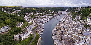
Looe is a coastal town and civil parish in south-east Cornwall, England, with a population of 5,280 at the 2011 census.

The Spree is, with a length of approximately 400 kilometres (250 mi), the main tributary of the River Havel, and at their confluence in Berlin-Spandau, is much longer than the Havel, which itself flows into the Elbe at Havelberg. The river rises in the Lusatian Highlands, that are part of the Sudetes, in the Lusatian part of Saxony, where it has three sources: the historical one called Spreeborn in the village of Spreedorf, the water-richest one in Neugersdorf, and the highest elevated one in Eibau. The Spree then flows northwards through Upper and Lower Lusatia, where it crosses the border between Saxony and Brandenburg. After passing through Cottbus, it forms the Spree Forest, a large inland delta and biosphere reserve. It then flows through Lake Schwielochsee before entering Berlin, as Müggelspree(listen ).

The South West Coast Path is England's longest waymarked long-distance footpath and a National Trail. It stretches for 630 miles (1,014 km), running from Minehead in Somerset, along the coasts of Devon and Cornwall, to Poole Harbour in Dorset. Because it rises and falls with every river mouth, it is also one of the more challenging trails. The total height climbed has been calculated to be 114,931 ft (35,031 m), almost four times the height of Mount Everest. It has been voted 'Britain's Best Walking route' twice in a row by readers of The Ramblers' Walk magazine, and regularly features in lists of the world's best walks.
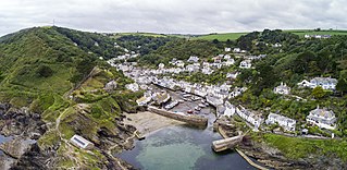
Polperro is a large village, civil parish, and fishing harbour within the Polperro Heritage Coastline in south Cornwall, England. Its population is around 1,554.

Talland is a hamlet and ecclesiastical parish between Looe and Polperro on the south coast of Cornwall. It is in the civil parish of Polperro and consists of a church, the Old Vicarage and a few houses.

Hessenford is a small village in south-east Cornwall, United Kingdom, four miles west of St Germans on the A387 Polbathic to Polperro road. The village had a population of 170 at the 2001 census. It is in the civil parish of Deviock. The river Seaton runs through the village and a mill was recorded here in 1286; the last mill closing in the mid-20th century.

Cornish mythology is the folk tradition and mythology of the Cornish people. It consists partly of folk traditions developed in Cornwall and partly of traditions developed by Britons elsewhere before the end of the first millennium, often shared with those of the Breton and Welsh peoples. Some of this contains remnants of the mythology of pre-Christian Britain.

The Par River, also known as the Luxulyan River is a river draining the area north of St Blazey in Cornwall, in the United Kingdom.
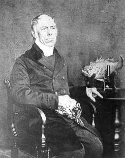
Jonathan Couch was a Cornish naturalist, the only child of Richard and Philippa Couch, of a family long resident at Polperro, a small fishing village between Looe and Fowey, on the south coast of Cornwall. A blue plaque on the wall of Warren cottage commemorates his birthplace.

Lansallos is a village in the civil parish of Polperro in south Cornwall, England, United Kingdom. It is situated between Polruan and Polperro about 5 miles (8 km) east of Fowey in Liskeard Registration District.

Lanteglos is a coastal civil parish in south Cornwall, England, United Kingdom. It is on the east side of the tidal estuary of the River Fowey which separates it from the town and civil parish of Fowey. The South West Coast Path runs along the southern coasts of the parish and much of the southern part of the parish lies in the Polruan to Polperro Site of Special Scientific Interest managed by the National Trust.

The Polperro Gaffer is a type of fishing vessel used in Cornwall. The Great Gale of 1891 destroyed the fishing fleets of many of the smaller Cornish villages. The old boats were generally clinker-planked and lug-rigged. The new boats built after the Gale with government intervention and support were to a new design, carvel planked and with the "modern" gaff rig, boats we now know as typically West Country with straight stem and transom sterns though the lines varied from port to port.

Fishing in Cornwall, England, UK, has traditionally been one of the main elements of the economy of the county. Pilchard fishing and processing was a thriving industry in Cornwall from around 1750 to around 1880, after which it went into an almost terminal decline. During the 20th century the varieties of fish taken became much more diverse and crustaceans such as crab and lobster are now significant. Much of the catch is exported to France due to the higher prices obtainable there. Though fishing has been significantly damaged by overfishing, the Southwest Handline Fishermen's Association has started to revive the fishing industry. As of 2007, stocks are improving. The Cornwall Sea Fisheries Committee is one of 12 such committees responsible for managing the corresponding Sea Fisheries District. The Isles of Scilly Sea Fisheries Committee is responsible for the Scilly district.

The De Lank River is a small river in north Cornwall, England. It is a tributary of the River Camel and is approximately nine miles (14.5 km) long from its source on Bodmin Moor to its confluence with the Camel two miles (3 km) south of St Breward.

Killigarth Manor is a Grade II listed former manor house in the civil parish of Polperro in Cornwall, United Kingdom. It is in the hamlet of Killigarth northeast of Polperro village. It has an 1872 datestone which marks the date when the older house was demolished, though its materials used in the building of the present house. Killigarth Manor is used as holiday accommodation. In the grounds are a holiday and caravan park. The small housing estate of Carey Park is nearby.

Crumplehorn is a hamlet in Cornwall, England. It forms the northern part of the village of Polperro, within the civil parish of Polperro and is located 4 miles (6.4 km) west of the town of Looe.

Polruan to Polperro is a coastal Site of Special Scientific Interest (SSSI) and Special Area of Conservation (SAC) in south-east Cornwall, England, UK, noted for its biological interest. It contains a wide variety of plant species and is a site for populations of breeding birds.

The River Lerryn is a river in east Cornwall, England, UK, a tributary of the River Fowey. The Lerryn is the largest of the tributaries which enter the estuary of the Fowey. The river is tidal up to the village of Lerryn. The landscape of the Lerryn catchment is rural and includes heathland, moorland and rough pasture in the upper reaches and broadleaf, coniferous and mixed plantation woodland in the lower. This catchment includes four SSSIs, including Redlake Meadows & Hoggs Moor. The Lerryn rises at Fairy Cross on the southern slopes of Bodmin Moor and flows south-southwest until it enters the Fowey estuary.

