
The Au Sable River in Michigan, United States runs approximately 138 miles (222 km) through the northern Lower Peninsula, through the towns of Grayling and Mio, and enters Lake Huron at the town of Oscoda. It is considered one of the best brown trout fisheries east of the Rockies and has been designated a blue ribbon trout stream by the Michigan Department of Natural Resources. A map from 1795 located in the United States Gazetteer calls it the Beauais River. In French, the river is called the Rivière au sable, literally "Sand River".

Iosco County is a county in the U.S. state of Michigan; its eastern border is formed by Lake Huron. As of the 2020 census, the population was 25,237. The county seat is Tawas City.

Oscoda Township is a charter township of Iosco County in the U.S. state of Michigan. The population was 6,788 at the 2020 census. The Wurtsmith Air Force Base is located within the township.
A Pure Michigan Byway is the designation for a segment of the State Trunkline Highway System in the US state of Michigan that is a "scenic, recreational, or historic route that is representative of Michigan's natural and cultural heritage." The designation was created with the name Michigan Heritage Route by the state legislature on June 22, 1993, and since then six historic, seven recreational and seven scenic byways have been designated by the Michigan Department of Transportation (MDOT), and another two have been proposed. These byways have been designated in both the Upper and Lower peninsulas of the state. The current name was adopted on December 30, 2014, and it references the Pure Michigan tourism marketing campaign.

M-37 is a north–south state trunkline highway in the US state of Michigan. The southern terminus is near the border between Kalamazoo and Calhoun counties at exit 92 of Interstate 94 (I-94) southwest of Battle Creek. The northern terminus is at the Mission Point Light on Old Mission Point in Grand Traverse County. In between, the highway connects Battle Creek, Grand Rapids and Traverse City. Motorists will travel through agricultural land, forests, suburbs and large cities along the way. The section of M-37 on the Old Mission Peninsula was designated what is now a Pure Michigan Scenic Byway in 2008.

M-33 is a north–south state trunkline highway in the US state of Michigan that runs from Interstate 75 (I-75) at Alger in Arenac County north to M-27 near Cheboygan. In between, the trunkline runs through rural sections of the northeastern Lower Peninsula including state and national forest areas. M-33 connects to a handful of parks and crosses several of the rivers in that section of the state. It runs concurrently with three other state highways, sharing pavement to connect through several small communities of Northern Michigan.

State Route 3 is a state highway in the U.S. state of California that serves Trinity and Siskiyou counties. It runs from SR 36 north along the shore of Trinity Lake, Fort Jones and Etna. The route then approaches Yreka, intersecting with Interstate 5 (I-5), and turns east to Montague. The road was numbered SR 3 in 1964, and most of it has been part of the state highway system since 1933.

F-41 is a county-designated highway in the Lower Peninsula of Michigan. It was previously designated as M-171, a former state trunkline highway, until 1960, running from US Highway 23 (US 23) just north of Oscoda, and coming back to US 23 about 20 miles (32 km) south of Alpena. The road runs through rural, forested areas of Iosco and Alcona counties, inland from Lake Huron.

M-72 is a state trunkline highway in the US state of Michigan, running from Lake Huron to Lake Michigan across the northern part of the Lower Peninsula. The highway connects M-22 in Empire with US Highway 23 (US 23) in Harrisville. It is one of only three Michigan state trunklines that cross the Lower Peninsula, shore to shore. In between, M-72 runs across Northern Michigan woodland, agricultural areas of the Leelanau Peninsula near Traverse City, and the Au Sable River watershed. The trunkline also provides access to Camp Grayling, a National Guard training facility near the city of the same name. Traffic levels along the highway vary from approximately 800 vehicles a day on the east end to over 32,000 vehicles near Traverse City.

M-55 is a state trunkline highway in the northern part of the US state of Michigan. M-55 is one of only three state highways that extend across the Lower Peninsula from Lake Huron to Lake Michigan; the others are M-46 and M-72. The highway crosses through rural forest and farmlands to connect Manistee with Tawas City. M-55 crosses two of the major rivers in the state. Two sections of the highway follow along freeways near Cadillac and West Branch. Running for 150.944 miles (242.921 km) through the state, M-55 is maintained by the Michigan Department of Transportation (MDOT).
The Catalina Highway, officially the General Hitchcock Highway, is the popular name for a Forest Highway and scenic route located in Pima County in southern Arizona. Also known as the Sky Island Scenic Byway, the Mount Lemmon Highway and Arizona Forest Highway 39, the Catalina Highway is the only paved roadway providing access to the resort village of Summerhaven as well as various recreational and scientific facilities located near the summit of Mount Lemmon. Ascending from the desert floor in Tucson to near the summit of Mount Lemmon, the short highway gains over 6,000 ft (1,800 m), showcasing a variety of climates ranging from lowland desert to alpine forests. The name sky island comes from the analogy of these mountains being like islands of forest in a sea of desert. It is designated as a scenic byway by the National Scenic Byways Program. and an Arizona Scenic Road by the Federal Highway Administration.

M-65 is a 103.176-mile-long (166.046 km) state trunkline highway in the US state of Michigan. The highway runs between termini on US Highway 23 (US 23) near Omer and Rogers City in the northeastern Lower Peninsula of the state. M-65 runs inland through several small communities in the region, passing through forests and fields along its course. M-65 crosses several watercourses, including the Au Sable River where it runs along the River Road National Scenic Byway. The region also includes the Huron National Forest and the Mackinaw State Forest areas.

M-116 is a 7.018-mile-long (11.294 km) state trunkline highway in the US state of Michigan that begins in Ludington at an intersection with US Highway 10 (US 10) at James Street and Ludington Avenue. The road travels northward, much of it along the shore of Lake Michigan before reaching its terminus at the entrance to Ludington State Park. The roadway has been in the state highway system since the late 1920s. It has been realigned a few times, most recently in the late 1990s.
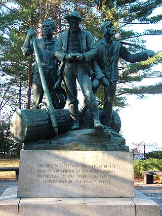
Lumberman's Monument is a monument dedicated to the workers of the early logging industry in Michigan. Standing at 14 feet, the bronze statue features a log surrounded by three figures: a timber cruiser holding a compass, a sawyer with his saw slung over his shoulder, and a river rat resting his peavey on the ground. The granite base of the statue is engraved with a memorial that reads "Erected to perpetuate the memory of the pioneer lumbermen of Michigan through whose labors was made possible the development of the prairie states." It is also inscribed with the names of the logging families who dedicated their time and efforts to the industry in the area. It was built in 1931, dedicated in 1932 and is managed by the USDA Forest Service. It is located in the northeastern part of the Lower Peninsula of Michigan along the Au Sable River within Huron-Manistee National Forests. Access to the park is on River Road, which intersects M-65 west of Oscoda, Michigan. Monument Road, from East Tawas, also leads directly to the monument, which is in Oscoda Township in Iosco County. The monument is part of the River Road Scenic Byway, a 22-mile (35 km) drive between Oscoda and South Branch that runs parallel with the beautiful Au Sable River. It is a designated National Scenic Byway.

US Highway 23 (US 23) is a north–south United States Numbered Highway that runs from Jacksonville, Florida, to Mackinaw City, Michigan. In the US state of Michigan, it is a major, 362-mile-long (583 km), north–south state trunkline highway that runs through the Lower Peninsula. The trunkline is a freeway from the Michigan–Ohio state line near Lambertville to the city of Standish, and it follows the Lake Huron shoreline from there to its northern terminus. Serving the cities of Ann Arbor and Flint, US 23 acts as a freeway bypass of the Metro Detroit area. Overall, the highway runs through rural areas of the state dominated by farm fields or woodlands; some segments are urban in character in the Ann Arbor, Flint and Tri-Cities areas. The section from Flint north to Standish also carries Interstate 75 (I-75) along a concurrency that includes a segment that carries almost 70,000 vehicles on a daily basis.

The Whitefish Bay National Forest Scenic Byway is a National Forest Scenic Byway that runs along Whitefish Bay in the Hiawatha National Forest in the U.S. state of Michigan. The byway mostly follows Federal Forest Highway 42 (FFH 42) through Chippewa County in the Upper Peninsula. As a forest highway, it is maintained jointly by the Chippewa County Road Commission (CCRC) and the U.S. Forest Service (USFS). The route of the byway first existed as an earth road by the 1930s; it was improved into a gravel road in the 1940s and paved between the 1950s and the 1980s. The byway designation was created in 1989.

The Black River National Forest Scenic Byway is a National Forest Scenic Byway that runs along the Black River in the Ottawa National Forest in the U.S. state of Michigan. The byway follows County Road 513 (CR 513) through Gogebic County in the Upper Peninsula. As a county road, it is maintained jointly by the Gogebic County Road Commission (GCRC) with assistance from the U.S. Forest Service (USFS). The byway provides access to several waterfalls and other visitor attractions in the area. The route of the byway first existed as a wagon road in the 1840s and as a county road in the 1920s. The byway designation was instituted on June 20, 1992, and the byway was dedicated later that year.

The Woodlands Trace National Scenic Byway, also known as "The Trace," is the major north–south roadway that traverses the Land Between the Lakes National Recreation Area in two counties in western Kentucky and northwestern Stewart County in northwest Middle Tennessee. It is estimated to be 43.1 miles (69.4 km) in length. The road is part of the National Scenic Byway system. Although it is not signed, it is listed on LBL's road logs as FD-100.

Loud Dam is a hydro-electric dam on the Au Sable River in Michigan and is located along the National Register of Historic Places River Road Scenic Byway in Northern Michigan. Loud Dam is also part of the River Road Scenic Byway and listed in the National Scenic Byways Program.


