
The River Avon is a river in the Strathspey area of the Scottish Highlands, and a tributary of the River Spey. It drains the north-eastern area of the Cairngorm Mountains and is largely contained within the Cairngorms National Park
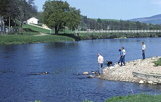
The River Spey is a river in the northeast of Scotland. At 98 mi (158 km) it is the eighth longest river in the United Kingdom and the second longest and fastest-flowing river in Scotland. (The Tay is the longest with the Clyde third in Scotland. It is an important location for the traditions of salmon fishing and whisky production in Scotland.
Ben Hope is a mountain in northern Scotland. It is the most northerly Munro, standing alone in the Flow Country south-east of Loch Hope in Sutherland. The mountain is a roughly triangular wedge, with a great crag on the west, with two lower shoulders to the south and northeast. Alpine flowers are abundant in season, although the ground is very rocky.

The Allt Graad or River Glass is a river in Easter Ross, Highland, Scotland. It is named on Ordnance Survey maps variously as Allt Graad and River Glass. It has also been known as the "Allt Grande", and the archaic Anglicization, "Aultgraad".

Gairich, sometimes Sgurr Gairoch, is a mountain in Lochaber in the Northwest Highlands of Scotland. It is on the southern side of Loch Quoich, with Glen Garry to the east and Glen Kingie to the south, 25 kilometres north-northwest of Fort William.

Ben Tee is a Scottish mountain situated in the Lochaber area of the Highland council area, some 15 kilometres north of Spean Bridge. It is rated as one of the best of Scotland's smaller mountains with Hamish Brown saying:
Ben Tee is such a shapely cone that it is instantly recognisable from anywhere around the Great Glen or along the Garry. Its isolated situation makes it one of Scotland’s finest summit viewpoints.

The River Truim is a right bank tributary of the River Spey in the Scottish Highlands. Its headwaters meet to the north of the Pass of Drumochter and flow northwards as the Truim past the dam at the northern end of Loch Ericht and through the village of Dalwhinnie, highest village in the Scottish Highlands. The distillery at Dalwhinnie producing Dalwhinnie Single Malt is also the highest in Scotland. The waters of its most significant tributary, the Allt Cuaich, are diverted in part along an aqueduct to Loch Ericht. The river continues north-northeastwards down Glen Truim, over the Falls of Truim and on to meet the Spey 2.5 miles (4 km) southwest of Newtonmore. It is closely followed for almost its entire length by both the A9 road and the mainline railway from Perth to Inverness.

The River Helmsdale is one of the major east-flowing rivers of Sutherland in the Highlands of Scotland. It flows broadly southeastwards from Loch Badanloch down the Strath of Kildonan, gathering the waters of the Bannock Burn on its left and the Abhainn na Frithe on its right before discharging into the Moray Firth on the North Sea at the town of Helmsdale. Other significant tributaries of the Helmsdale include the left-bank Suisgill Burn and the right-bank Craggie Water. Loch Achnamoine which is just over 1 km in length, lies on the line of the river 1 mi / 1.5 km downstream of Loch Badanloch. Loch Badanloch is one of a complex of three interconnecting lochs - the other two being Loch nan Clàr and Loch Rimsdale which gather waters from the moors on the southern edge of the Flow Country via the Allt an Lòin Tharsuinn, Allt Lòn a' Chùil and Rimsdale Burn.

The River Brora is an east-flowing river in Sutherland in the Highlands of Scotland. It is formed where its headwater streams, Allt Gobhlach and Allt nan Con-uisge meet. As a part of the Loch Shin Hydro Scheme, some of its flow is now diverted at Dalnessie into the Féith Osdail, a tributary of the River Tirry. It then flows southeastwards down Strath Brora to Dalreavoch. The river then briefly turns northeast and then east, before turning southeastwards once again to pass through the three distinct basins of Loch Brora to enter the Moray Firth on the North Sea at the town of Brora. Its one principal tributary is the Black Water which enters on its left bank at Balnacoil. The Black Water is itself fed by the River Skinsdale and the Coirefrois Burn.

The River Garry is a major tributary of the River Tummel, itself a tributary of the River Tay, in the traditional county of Perthshire in the Scottish Highlands. It emerges from the northeastern end of Loch Garry (56.8193°N 4.2311°W), just to the southeast of the Pass of Drumochter, and flows southeastwards and eastwards down Glen Garry to the narrow Pass of Killiecrankie beyond which it joins the Tummel (56.7182°N 3.7790°W).

The River Fiddich is a right bank tributary of the River Spey in northeast Scotland. It rises on the eastern slopes of Corriehabbie Hill in Glenfiddich Forest and flows northeastwards beneath the A941 road, past Auchindoun Castle to a sharp bend adjacent to the A920 road where it turns westwards to flow to Dufftown. The Fiddich is joined on the eastern edge of the town by the Dullan Water which drains Glen Rinnes. Their combined waters then flow generally northwestwards, passing beneath the B9014 road near Balvenie Castle and then the A95 at Craigellachie immediately before meeting the Spey.

The River Dulnain is a major left bank tributary of the River Spey in northeast Scotland. It rises in the eastern part of the Monadhliath Mountains and flows in a generally northeastward direction through uninhabited country to Sluggan, where it is crossed by Sluggan Bridge, constructed by General Wade to carry a military road. Turning more easterly, the Dulnain passes beneath the modern A9 road which bypasses Carrbridge, the mainline railway and, in Carrbridge itself, the Carrbridge Packhorse Bridge that gives the village its name and the bridge carrying the B9153 road. The final section flowing east-northeast to the village of Dulnain Bridge is accompanied by the A938 road. The river empties into the Spey after passing beneath the A95 road and the disused bridge of the former Strathspey railway.
The River Nethy is a right bank tributary of the River Spey in northeast Scotland. It rises as the Garbh Allt between Cairn Gorm and A' Chòinneach on the northern slopes of the Cairngorms and flows northwards through Strath Nethy and into Abernethy Forest. Passing through Nethy Bridge where the B970 road crosses the river and gives its name to the village, the Nethy turns northwestward before entering the Spey at Broomhill. Numerous burns feed the Nethy, the most significant of which is the Dorback Burn which enters from its right bank a mile above Nethy Bridge.

The River Feshie is a major right bank tributary of the River Spey in north-east Scotland. It rises in the remote countryside of the Glenfeshie Forest, flowing initially eastwards before turning sharply to the northwest as a result of the capture of the waters of Geldie Burn. After gaining the waters of the River Eidart on its right bank and dropping down into Glen Feshie, it flows northwards through the wooded glen and is often braided in nature. It is joined by several burns which descend steeply from the Cairngorm plateau to the east and, on its left bank, by the Allt Chomhraig near Balachroick. The river passes beneath the B970 road at Feshiebridge and after a further 1.5 miles (2.5 km) it joins the Spey near the village of Kincraig.

The River Druie is a right bank tributary of the River Spey in northeast Scotland. The Druie tributaries are Am Beanaidh, which emerges from Loch Einich and flows north through Gleann Einich; and the River Luineag, which emerges from Loch Morlich within the Glenmore Forest Park and receives all the drainage from the northern slopes of Cairn Gorm. These meet immediately above the bridge carrying the B970 road over the river at Coylumbridge. From this point the Druie flows 1.5 miles (2.5 km) past Inverdruie to meet the Spey at the southern end of Aviemore.

The River Calder is a left bank tributary of the River Spey in the Scottish Highlands. Its headwaters are the t-Allt Ballach, Allt an Lochain Dubh and Allt Madagain which drain the mountain slopes at the southeastern corner of the Monadhliath. Their waters are added to by those of the Allt Fionndraigh and Allt a' Chaorainn dropping down into Glen Banchor from the north. The river turns southeastwards and skirts the western edge of Newtonmore, running beneath the A86 road before joining the Spey at Spey Bridge.

The River Nairn is a 35 mile long river in the Scottish Highlands.

The East Highland Way is a long-distance walking route in Scotland that connects Fort William (56.8178°N 5.1109°W) with the ski and mountain resort of Aviemore (57.1899°N 3.8292°W). The route was described by Kevin Langan in 2007. The name is derived from the fact that the route terminates in Aviemore at the eastern edge of Highland region. The EHW route takes in a varied and wild landscape through deep forest plantations, passing many highland lochs and negotiating unspoilt marshlands. The route also explores the ancient Caledonian forests of Inshriach. The walk is 82 miles (132 km) long.

The Lairig an Laoigh is a mountain pass through the Highlands of Scotland. In speech and sometimes in writing the name is reduced to "Lairig Laoigh". It is of glacial origin, dissecting the Cairngorm plateau, and it runs roughly north–south from Speyside to Deeside at one time being used as a drove road. Between the public road in the Abernethy Forest and the one at Linn of Dee the trekking distance is 31 kilometres (19 mi).
