Related Research Articles
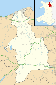
Denbighshire is a county in the north-east of Wales. Its borders differ from the historic county of the same name. This part of Wales contains the country's oldest known evidence of habitation – Pontnewydd (Bontnewydd-Llanelwy) Palaeolithic site has Neanderthal remains of some 225,000 years ago. Castles include Denbigh, Rhuddlan, Ruthin, Castell Dinas Bran and Bodelwyddan. St Asaph, one of Britain's smallest cities, has one of its smallest Anglican cathedrals. Denbighshire is bounded by coastline to the north and hills to the east, south and west. The River Clwyd follows a broad valley with little industry: crops appear in the Vale of Clwyd and cattle and sheep in the uplands. The coast attracts summer visitors; hikers frequent the Clwydian Range, part of the Clwydian Range and Dee Valley Area of Outstanding Natural Beauty. Llangollen International Musical Eisteddfod takes place each July.
Flintshire, also known as the County of Flint, is one of Wales' thirteen historic counties, and a former administrative county. It mostly lies on the north-east coast of Wales.

The River Clwyd is a river in Wales that rises in the Clocaenog Forest 5 mi (8 km) northwest of Corwen. Its total length is 35 mi (56 km).
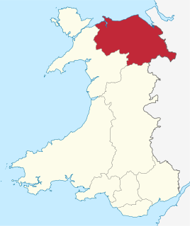
Clwyd is a preserved county of Wales, situated in the north-east corner of the country; it is named after the River Clwyd, which runs through the area. To the north lies the Irish Sea, with the English ceremonial counties of Cheshire to the east and Shropshire to the south-east. Powys and Gwynedd lie to the south and west respectively. Clwyd also shares a maritime boundary with Merseyside along the River Dee. Between 1974 and 1996, a slightly different area had a county council, with local government functions shared with six district councils. In 1996, Clwyd was abolished, and the new principal areas of Conwy County Borough, Denbighshire, Flintshire and Wrexham County Borough were created; under this reorganisation, "Clwyd" became a preserved county, with the name being retained for certain ceremonial functions.

The River Dwyryd is a river in Gwynedd, Wales which flows principally westwards; draining to the sea into Tremadog Bay, south of Porthmadog.
The Vale of Clwyd is a tract of low-lying ground in the county of Denbighshire in north-east Wales. The Vale extends south-southwestwards from the coast of the Irish Sea for some 20 miles forming a triangle of low ground bounded on its eastern side by the well-defined scarp of the Clwydian Range and to the west by numerous low hills. The River Clwyd which rises within Clocaenog Forest, southwest of Denbigh, runs the full length of the vale. It is joined by the two major left bank tributaries of the River Clywedog and River Elwy and the smaller right bank tributary of the River Wheeler.
The River Tâf is a river in West Wales. It rises in the Preseli Hills, Pembrokeshire, and continues through Carmarthenshire to Laugharne. It is one of the three rivers to enter the sea on the east side of Carmarthen Bay. The other two are the River Gwendraeth and River Tywi,

The Clwydian Range is a series of hills in the north-east of Wales that runs from Llandegla in the south to Prestatyn in the north, with the highest point being the popular Moel Famau. The range forms part of the Clwydian Range and Dee Valley Area of Outstanding Natural Beauty.

The A494 is a trunk road in Wales and England. The route, which is officially known as the Dolgellau to South of Birkenhead Trunk Road, runs between the terminus of the M56 motorway between Mollington and Capenhurst and the A470 at Dolgellau, Gwynedd. Its northern sections remain among the busiest roads in Wales.

The River Elwy is a river in Wales forming a tributary to the River Clwyd. The source of the river is sometimes said to be on the northern flank of Moel Seisiog, south-east of Llanrwst, at Ordnance Survey grid reference SH 853593. However the river only receives the name Elwy at the village of Llangernyw, where three rivers, Afon Cledwen, Afon Collen and Afon Gallen, meet to form the Elwy. It flows eastwards through Llanfair Talhaiarn and a few miles downstream from this village it is joined by a tributary, the River Aled which has its source in Llyn Aled.

The River Alyn is a tributary of the River Dee. The River Alyn rises at the southern end of the Clwydian hills and the Alyn Valley forms part of the Clwydian Range and Dee Valley Area of Outstanding Natural Beauty. The main town on the river Alyn is Mold, the county town of Flintshire. It lends its name to the constituencies of Alyn and Deeside in the UK Parliament and the Senedd.

Ffrith is a small village in the community of Llanfynydd in Flintshire, north-east Wales.

The River Cegidog is a river in north-east Wales. It flows mainly through Flintshire but towards the end of its course it forms the border between Flintshire and Wrexham County Borough.
Llanelidan is a small village and community in the county of Denbighshire in north-east Wales. The community also includes the hamlet of Rhyd-y-Meudwy.

The River Dysynni is a river in mid Wales. Its source is the Tal-y-llyn Lake just south of the Cadair Idris massif and its mouth is in the Cardigan Bay area of the Irish Sea to the north of Tywyn. It measures about 16 mi (26 km) in length.

The Afon Fathew is a river in Gwynedd, north-west Wales. The river is downstream from the Dolgoch Falls which is a popular nature site, and is followed for much of its course by the Talyllyn Railway.

The River Clywedog is a tributary of the River Clwyd in northeast Wales. The river rises within Clocaenog Forest and flows in a generally easterly direction through the villages of Cyffylliog, Bontuchel and Rhewl before turning northwards to join the Clwyd to the east of Denbigh.

Llannefydd is a village and community in Conwy County Borough, in Wales. It is located on the border with Denbighshire, between the Afon Aled and River Elwy, 5.7 miles (9.2 km) north west of Denbigh, 5.8 miles (9.3 km) south west of St Asaph, 6.9 miles (11.1 km) south of Abergele and 15.2 miles (24.5 km) south east of Conwy. In the 2011 census the community parish had a population of 590. The community includes the village of Cefn Berain.

Aberwheeler is a village and community in the Welsh county of Denbighshire, located on the south bank of the River Wheeler, 4.2 miles (6.8 km) north east of Denbigh, 12.6 miles (20.3 km) north west of Mold and 11.0 miles (17.7 km) north of Ruthin. At the 2001 census the community had a population of 327, reducing to 298 at the 2011 census. The name has been Anglicised from the Welsh.

The Clwydian Range and Dee Valley is a designated Area of Outstanding Natural Beauty (AONB) and proposed national park, located in north-east Wales, covering the Clwydian Range, and the valley of the River Dee. Designated in 1985 as the Clwydian Range AONB, and expanded to its current form in 2011, the Area of Outstanding Natural Beauty includes: medieval field systems, open heather moorland, prehistoric hillforts, limestone crags, broad leaved woodland, wooded valleys, and farmland. In 2018, an estimated 1.1 million people visited six key sites across the AONB, generating approximately £24.1 million to the Welsh economy, according to Natural Resources Wales. The AONB falls within the jurisdiction of the local authorities of Denbighshire, Flintshire, and Wrexham County Borough, with the majority, 80% of the AONB in Denbighshire, and the remaining 20% split evenly between the other two authorities. The AONB is the largest of only five AONBs in Wales, and one of the 46 in the United Kingdom. Additionally, it is one of only 8 protected areas of Wales. Long-distance footpaths; Offa's Dyke Path, and the Clwydian Way pass through the AONB. The area of the Clwydian Range and Dee Valley AONB is 390 km2 (150 sq mi), and has been proposed by the Welsh Government to become Wales' fourth national park.
References
- ↑ "Bing maps" . Retrieved 29 December 2019.
- ↑ Map sheet (England and Wales) 108 Flint. Keyworth, Nottingham: British Geological Survey. 1999.