
Daufuskie Island, located between Hilton Head Island and Savannah, is the southernmost inhabited sea island in South Carolina. It is 5 miles (8 km) long by almost 2.5 miles (4.0 km) wide – approximate surface area of 8 square miles (21 km2). With over 3 miles (5 km) of beachfront, Daufuskie is surrounded by the waters of Calibogue Sound, the Intracoastal Waterway and the Atlantic Ocean. It was listed as a census-designated place in the 2020 census with a population of 557.
Frogmore is an unincorporated community on St. Helena Island in Beaufort County, South Carolina, United States, along U.S. Route 21.

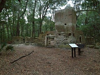
Tabby is a type of concrete made by burning oyster shells to create lime, then mixing it with water, sand, ash and broken oyster shells. Tabby was used by early Spanish settlers in present-day North Carolina and Florida, then by British colonists primarily in coastal South Carolina and Georgia. It is a man-made analogue of coquina, a naturally-occurring sedimentary rock derived from shells and also used for building.
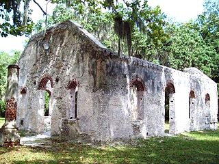
St. Helena Parish Chapel of Ease Ruins is a historic site in Frogmore, South Carolina on Saint Helena Island.
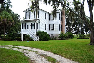
Stoney-Baynard Plantation on Hilton Head Island, SC was listed on the National Register of Historic Places in 1994. The listing included one contributing site on 6 acres (2.4 ha).

Coffin Point Plantation, is a historic plantation house located in the Frogmore area of Beaufort County, South Carolina, USA. A Sea Island plantation, it profited from the labor of enslaved people.

The Frogmore Plantation Complex, located on Saint Helena Island, in Beaufort County, South Carolina, is significant for several reasons. First, the plantation home, along with its contributing properties, offers an excellent example of the area's architectural development from 1790–1920. Second, the plantation's long association with prominent families contributes to its significance. The plantation was first owned by Lieutenant Governor William Bull, who then willed it to his son in 1750.
Isaac Fripp House Ruins is a historic house ruin and archaeological site located on Saint Helena Island near Frogmore, Beaufort County, South Carolina. The ruins are located at Bay View overlooking the junction of Chowan Creek and the Beaufort River. The two-story, tabby house dates to the early- to mid-19th century. It is associated with Isaac Fripp, a planter of sea island cotton and other staples on St. Helena Island.
The Green is a historic open-space located on Saint Helena Island near Frogmore, Beaufort County, South Carolina. It is the site of community meetings, celebrations, and other gatherings. The Green was the site of the first Darrah Hall, an auditorium and community center built about 1885 by Penn School, and destroyed in 1893. Since that time the Green has continued to serve as a gathering place for the people of St. Helena Island. At the rear of The Green is the Knights of Wise Men Lodge.
The Oaks, also known as the Cooler House, is a historic plantation house located on Saint Helena Island near Frogmore, Beaufort County, South Carolina. It was built about 1855, and is a two-story, vernacular frame I-House. Edward L. Pierce chose The Oaks as his headquarters during the military occupation of St. Helena during the American Civil War. The Oaks was the center for military and agricultural activities on the island. On June 18, 1862, Ellen Murray, who had ten days earlier arrived from Pennsylvania, opened the Penn School for Freedmen in a back room of the house. The house also served as a hotel for military personnel from Port Royal, superintendents, and teachers.
Lands End Road Tabby Ruins is a historic archeological site located on Saint Helena Island near Frogmore, Beaufort County, South Carolina. The site contains the archaeological remains of a large late-18th to early-19th century house. The site has a tabby foundation pier and the partial outlines of a structure.
St. Helenaville Archaeological Site is a historic archeological site located on Saint Helena Island near Frogmore, Beaufort County, South Carolina. St. Helenaville was a small antebellum village and summer retreat located on the northeastern end of St. Helena Island. St. Helenaville was damaged by several major storms, which ultimately caused part of the village to fall into the sound. There is very little historical documentation of the village. Several remains of tabby and brick are evident.
Tombee Plantation is a historic plantation house located on Saint Helena Island near Frogmore, Beaufort County, South Carolina. It was built about 1790–1800, and is two-story, T-shaped frame dwelling. It is sheathed in clapboard and has a gable roof. It features a single-story front portico with four square columns and a two-story balustraded rear porch with six square columns on each floor. Along with Seaside Plantation, it is one of the few surviving antebellum plantation houses remaining on St. Helena Island. The Tombee Plantation property was divided into tracts during the days of the "Port Royal Experiment" in 1862. It remained in the hands of descendants of freed slaves until 1971.
Seaside Plantation, also known as the Edgar Fripp Plantation, is a historic plantation house located on Saint Helena Island near Beaufort, Beaufort County, South Carolina. It was built about 1795 to 1810, and is a two-story, frame dwelling in a transitional Georgian / Federal style. It features one-story hip roofed portico. Seaside was one of the plantations participating in the Port Royal Experiment and had as its labor superintendent Charles Pickard Ware (1840–1921). Charlotte Forten Grimké (1837-1914) also resided at Seaside Plantation. Along with Tombee Plantation, Seaside is one of only a few remaining antebellum plantation houses on St. Helena. Also on the property are the contributing original, brick-lined well, a clapboard shed, a large barn with clapboard siding and tin roof, and a round concrete and oyster shell silo.
Robert Simmons House, also known as the Willie Simmons House, is a historic home located on Saint Helena Island near Frogmore, Beaufort County, South Carolina. The original section was built about 1910 by farmer Robert Simmons, and subsequently expanded. It is a double pen house type on metal piers, with a full-width shed roof porch supported by wood posts. It is a rare example of a vernacular architectural form once common to St. Helena Island.
Orange Grove Plantation is a historic plantation house and national historic district located on Saint Helena Island near Frogmore, Beaufort County, South Carolina. The district encompasses one contributing building and two contributing sites, and reflects the early-20th century influx of Northerners onto St. Helena Island. The plantation was first recorded in 1753 when Peter Perry purchased 473 acres. Perry owned 46 chattel slaves. The plantation house, built about 1800, was in poor condition when Henry L. Bowles (1866-1932), a U.S. Representative from Massachusetts, bought the property in 1928. He demolished it and built the present house in the same year. The property also includes the tabby ruin of the kitchen, built about 1800, and a tabby-walled cemetery containing three early-19th century graves of the Fripp and Perry families.
Pine Island Plantation Complex is a historic hunting plantation complex and national historic district located on Pine Island near Frogmore, Beaufort County, South Carolina. The district encompasses six contributing buildings and one contributing sites, and is an early-20th century hunting plantation. The main house at Pine Island was built about 1904, and is a two-story frame structure built on an existing tabby foundation. The front façade features a full-width two-story porch. Also on the property are the contributing cottage, a toolshed/doghouse, a barn, a pumphouse, an automobile garage, and causeway.
Laurel Bay Plantation, also known as Woodward Plantation and Tabby Ruin Site, is a historic archaeological site located near Beaufort, Beaufort County, South Carolina. The site contains artifacts associated with domestic outbuilding activities related to either or both Laurel Bay Plantation and Woodward Plantation. Features present at the site include sections of two tabby walls, a tabby structure foundation, two depressions, two brick piles, and a shell pile.

Sams Plantation Complex Tabby Ruins is a historic plantation complex and archaeological site located at Frogmore, Beaufort County, South Carolina. The site, possibly built upon and occupied well before 1783. It includes the ruins and/or archaeological remains of at least 12 tabby structures. They include the main plantation house, a rectangular enclosure consisting of tabby walls, a large tabby kitchen, and five tabby slave quarters. Also on the property were a variety of tabby dependencies including a barn/stable, a smoke house or blade house, a well/dairy house, and a well. The property also includes the Sams family cemetery and Episcopal chapel enclosed by high tabby walls. Other structures include possibly an overseer's house, a granary/mill, and a tabby cotton house. During and subsequent to the American Civil War the Sams Tabby Complex was occupied by freedman. Following the Civil War the plantation house was destroyed by hurricanes.
Hephzibah Jenkins Townsend's Tabby Oven Ruins is a historic archaeological site located at Edisto Island, Charleston County, South Carolina. The remains represent what was essentially a commercial bakery.


