Roaring Fork River is a tributary of the Colorado River, approximately 70 miles (110 km) long, in west central Colorado in the United States. The river drains a populated and economically vital area of the Colorado Western Slope called the Roaring Fork Valley or Roaring Fork Watershed, which includes the resort city of Aspen and the resorts of Aspen/Snowmass.
Roaring Fork may refer to:

Mount Jefferson is a mountain located on the Continental Divide between Fremont County of northeastern Idaho and Beaverhead County of southwestern Montana. Mount Jefferson is the highest point of the Centennial Mountains, whose crest runs along the Continental Divide and can be climbed using a class 2 route (scramble) from the access road to neighboring Sawtell Peak.

The Monongahela National Forest is a national forest located in the Allegheny Mountains of eastern West Virginia, USA. It protects over 921,000 acres of federally owned land within a 1,700,000 acres proclamation boundary that includes much of the Potomac Highlands Region and portions of 10 counties.

The Dolly Sods Wilderness — originally simply Dolly Sods — is a U.S. Wilderness Area in the Allegheny Mountains of eastern West Virginia, USA, and is part of the Monongahela National Forest (MNF) of the U.S. Forest Service (USFS).
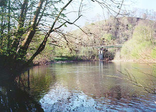
The Powell River in the United States rises in southwest Virginia and flows into East Tennessee.

The George Washington and Jefferson National Forests are U.S. National Forests that combine to form one of the largest areas of public land in the Eastern United States. They cover 1.8 million acres (7,300 km2) of land in the Appalachian Mountains of Virginia, West Virginia, and Kentucky. Approximately 1 million acres (4,000 km2) of the forest are remote and undeveloped and 139,461 acres (564 km2) have been designated as wilderness areas, which eliminates future development.

The Elk Mountains are a high, rugged mountain range in the Rocky Mountains of west-central Colorado in the United States. The mountains sit on the western side of the Continental Divide, largely in southern Pitkin and northern Gunnison counties, in the area southwest of Aspen, south of the Roaring Fork River valley, and east of the Crystal River. The range sits west of the Sawatch Range and northeast of the West Elk Mountains. Much of the range is located within the White River National Forest and the Gunnison National Forest, as well as the Maroon Bells-Snowmass Wilderness and Raggeds Wilderness. The Elk Mountains rise nearly 9,000 ft. above the Roaring Fork Valley to the north.

The Roaring Fork Valley is a geographical region in western Colorado in the United States. The Roaring Fork Valley is one of the most affluent regions in Colorado and the U.S. as well as one of the most populous and economically vital areas of the Colorado Western Slope. The Valley is defined by the valley of the Roaring Fork River and its tributaries, including the Crystal and Fryingpan River. It includes the communities of Aspen, Snowmass Village, Basalt, Carbondale, and Glenwood Springs. Mount Sopris and the Roaring Fork River serve as symbols of the Roaring Fork Valley.

Seneca Creek is a 19.6-mile-long (31.5 km) tributary of the North Fork of the South Branch of the Potomac River located entirely within Pendleton County, West Virginia, USA.

North Fork Mountain is a quartzite-capped mountain ridge in the Ridge and Valley physiographic province of the Allegheny Mountains of eastern West Virginia, USA. Kile Knob, at 4,588 feet, is the mountain's highest point, and Panther Knob and Pike Knob are nearly as high.

Roaring Fork is a stream in the Great Smoky Mountains of Tennessee, located in the Southeastern United States. Once the site of a small Appalachian community, today the stream's area is home to the Roaring Fork Motor Nature Trail and the Roaring Fork Historic District.
Roaring Fork Conservancy is the watershed conservation organization for the Roaring Fork Watershed in west central Colorado, which operates to raise public awareness of the protection of the Roaring Fork Watershed. Roaring Fork Conservancy programs include water quality monitoring, river and water research, land and water conservation, river stewardship, and river and water education for students and adults. Roaring Fork Conservancy works collaboratively with local citizens, governments, agencies and partner organizations to protect rivers and streams of the Roaring Fork Watershed.

Roaring Fork Mountain is located in the southern Wind River Range in the U.S. state of Wyoming. Roaring Fork Mountain sits along the Continental Divide.

Beartown Wilderness is a U.S. wilderness area in the Eastern Divide Ranger District of the George Washington and Jefferson National Forests. It is a very rural Wilderness, consisting of an area of 5,613 acres (22.72 km2) with elevations ranging from 2,400 to 4,800 feet. It was created from existing National Forest lands in 1984 by the Virginia Wilderness Act of 1984.

The Roaring River is a 16.6-mile (26.7 km) long tributary of the South Fork Kings River, in the Sierra Nevada of Fresno County, California. The entire course of the river is within Kings Canyon National Park.