The Potomac River drains the Mid-Atlantic United States, flowing from the Potomac Highlands into Chesapeake Bay. It is 405 miles (652 km) long, with a drainage area of 14,700 square miles (38,000 km2), and is the fourth-largest river along the East Coast of the United States and the 21st-largest in the United States. Over 5 million people live within its watershed.

Beckley is a city in and the county seat of Raleigh County, West Virginia, United States. It was founded on April 4, 1838. This city is the home of the West Virginia University Institute of Technology or West Virginia University, Beckley Campus.

The Tennessee River is the largest tributary of the Ohio River. It is approximately 652 miles (1,049 km) long and is located in the southeastern United States in the Tennessee Valley. The river was once popularly known as the Cherokee River, among other names, as the Cherokee people had their homelands along its banks, especially in what are now East Tennessee and northern Alabama. Additionally, its tributary, the Little Tennessee River, flows into it from Western North Carolina and northeastern Georgia, where the river also was bordered by numerous Cherokee towns. Its current name is derived from the Cherokee town, Tanasi, which was located on the Tennessee side of the Appalachian Mountains.
The Army of the Shenandoah was a Union army during the American Civil War. First organized as the Department of the Shenandoah in 1861 and then disbanded in early 1862, it became most effective after its recreation on August 1, 1864, under Philip Sheridan. Its Valley Campaigns of 1864 rendered the Shenandoah Valley of Virginia unable to produce foodstuffs for the Confederate States Army, a condition which would speed the end of the Civil War.

The Shenandoah River is the principal tributary of the Potomac River, 55.6 miles (89.5 km) long with two forks approximately 100 miles (160 km) long each, in the U.S. states of Virginia and West Virginia. The river and its tributaries drain the central and lower Shenandoah Valley and the Page Valley in the Appalachians on the west side of the Blue Ridge Mountains, in northwestern Virginia and the Eastern Panhandle of West Virginia. There is a hydroelectric plant along the Shenandoah river constructed in 2014 by Dominion.
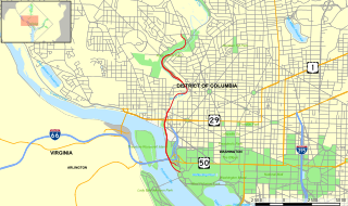
The Rock Creek and Potomac Parkway, informally called the Rock Creek Parkway, is a parkway maintained by the National Park Service as part of Rock Creek Park in Washington, D.C. It runs next to the Potomac River and Rock Creek in a generally north–south direction, carrying four lanes of traffic from the Lincoln Memorial and Arlington Memorial Bridge north to a junction with Beach Drive near Connecticut Avenue at Calvert Street, N.W., just south of the National Zoological Park.

The George Washington and Jefferson National Forests is an administrative entity combining two U.S. National Forests into one of the largest areas of public land in the Eastern United States. The forests cover 1.8 million acres (7,300 km2) of land in the Appalachian Mountains of Virginia, West Virginia, and Kentucky. Approximately 1 million acres (4,000 km2) of the forest are remote and undeveloped and 139,461 acres (564 km2) have been designated as wilderness areas, which prohibits future development.
Neabsco Creek is a 13.9-mile-long (22.4 km) tributary of the lower tidal segment of the Potomac River in eastern Prince William County, Virginia. The Neabsco Creek watershed covers about 27 square miles (70 km2). The name Neabsco is derived from a Doeg village recorded as Niopsco by early English colonists. The creek has served as a vital waterway for trade and commerce in northern Virginia since the eighteenth century.

Thomas Henry Carter was an artillery officer in the Confederate States Army during the American Civil War. His battalion played an important role in the Battle of Gettysburg.
Shubal Stearns, was a colonial evangelist and preacher during the Great Awakening. He converted after hearing George Whitefield and planted a Baptist Church in Sandy Creek, Guilford County, North Carolina. Stearns' highly successful ministry was related to the rise and expansion of the Separate Baptists — especially in much of the American South.
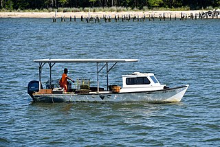
The Chesapeake Bay deadrise or deadrise workboat is a type of traditional fishing boat used in the Chesapeake Bay. Watermen use these boats year round for everything from crabbing and oystering to catching fish or eels.
Deep Creek High School is a public secondary school in Chesapeake, Virginia. It is part of Chesapeake City Public Schools and is located on 2900 Margaret Booker Drive.

Ivy is a census-designated place (CDP) in Albemarle County, Virginia, United States. The population as of the 2010 Census was 905. It is a small unincorporated community located on U.S. Route 250, just west of Charlottesville.
Smith Creek is a 35.5-mile-long (57.1 km) tributary stream of the North Fork of the Shenandoah River in the Shenandoah Valley of Virginia. Its watershed comprises 106 square miles (270 km2) within Shenandoah and Rockingham counties on the western slope of the Massanutten Mountain ridge. Its headwaters lie in Rockingham County just north of Harrisonburg, and its confluence with the North Fork of the Shenandoah River is located just south of Mount Jackson.

Union District, formerly Union Magisterial District, is one of five historic magisterial districts in Jackson County, West Virginia, United States. The district was originally known as Hushan's Mills Township, one of five civil townships established in 1863, at the height of the Civil War; it was subsequently given the patriotic name of Union Township. In 1872, West Virginia's townships were converted into magisterial districts. When Jackson County was redistricted in the 1990s, the area of Union District was included in the new Western Magisterial District. However, the county's historic magisterial districts continue to exist in the form of tax districts, serving all of their former administrative functions except for the election of county officials.

The North Branch Potomac River flows from Fairfax Stone in West Virginia to its confluence with the South Branch Potomac River near Green Spring, West Virginia, where it turns into the Potomac River proper.