Robert Gray's Columbia River expedition was conducted in 1792 in the Pacific Northwest. In May of that year, American merchant sea captainRobert Gray sailed into the Columbia River, becoming the first recorded American to navigate into it. The voyage, conducted on the privately owned Columbia Rediviva, was eventually used as a basis for the United States' claim on the Pacific Northwest, although its relevance to the claim was disputed by the British. As a result of the outcome the river was afterwards named after the ship. Gray spent nine days on the river trading fur pelts before sailing out of the river.
During his first voyage to the northwest coast, Gray was second-in-command of Columbia Rediviva under Captain John Kendrick, who remained in the Pacific, in command of Lady Washington. On the journey north along the coast to Nootka Sound, Gray encountered a strong outflow near 46'16". He spent nine days trying to enter the river without success before abandoning the effort and sailing north for Nootka.[3] Gray rejoined Kendrick for a time after Gray's return to the region.[2][self-published source] In October Columbia Rediviva and crew began building Fort Defiance and a small craft called Adventure as they prepared to ride out the winter in harbor.[4] After wintering on Vancouver Island, Gray set sail again on April 2, 1792, when he left the American trading post of Clayoquot on Vancouver Island.[2][self-published source] On this journey aboard Columbia Rediviva Gray noticed muddy waters flowing from shore and decided to investigate his belief that it might be the "Great River of the West".[1] While waiting for favorable weather, Gray spotted a ship and exchanged greetings with her on April 29. This ship was HMSDiscovery commanded by British naval captain George Vancouver, who doubted that Gray had found a navigable river-mouth.[2][self-published source]
The several large rivers and capacious inlets that have been described as discharging their contents into the Pacific between the 40th and 48th degree north latitude, were reduced to brooks insufficient for our vessels to navigate, or to bays inapplicable for refitting.
Gray informed Vancouver at this chance meeting that he had located a large river at the latitude of 46'10" but had been unable to enter it due to the outflow.[6] However, Vancouver still doubted any river existed there:
this was probably the opening found by me on the forenoon of the 27th, and was inaccessible, not from the current, but from the breakers which extend across it.[6][7]
So Gray informed Vancouver that he would further investigate that area, and then sailed south after several more days near the Strait of Juan de Fuca.[8]
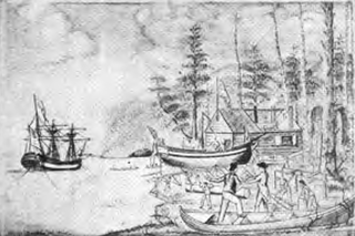
Entering the Columbia
Columbia Rediviva on the river.
The treacherous and shifting sand bar at the mouth of the Columbia River Estuary presented a challenge to any ship that attempted to enter the river. In April, Gray attempted to enter the mouth of the river, but bad weather forced him to give up.[9]
After sailing north, meeting Vancouver, and spending a time in Grays Harbor, as it was later named, Gray returned to the river. This time he ordered a small sailboat launched to attempt to find a safe passage across the sand bars in the process known as sounding.[2][self-published source] Finally in the evening of May 11, 1792, Gray's men found a safe channel, and so ship and crew sailed into the estuary of the Columbia River.[10] Once there they sailed upriver and Gray named this large river Columbia after his ship.[2][self-published source] The natives called the river Wimahl which translated to Big River.[9] In addition to naming the river, Gray also named other landmarks such as Adams Point and Cape Hancock.[11][pageneeded] However, many of these places have since been renamed. The farthest point Gray explored upriver is now known as Grays Bay, and the river that flows into it Grays River. These names were not given by Gray, but by William Broughton, George Vancouver's lieutenant, who explored the Columbia in October 1792. Robert Gray had made a chart of the bay and the mouth of the river, a copy of which was acquired by Vancouver.[12]
Once entering the Columbia's estuary, according to the ship's log, they were met by many natives in their canoes, while the crew prepared to take on fresh water.[11][pageneeded]
When we were over the bar we found this to be a large river of fresh water up which we steered. Many canoes came alongside. At 1:00 P.M. came to with the small bower, in ten fathoms, black and white sand. …people employed in pumping the salt water out of our water-caskets in order to fill with fresh, while the ship floated in. So ends.
Trading with the locals consisted mainly of exchanging nails and other small iron products for pelts, salmon, and animal meat such as deer and moose.[11][pageneeded] During the nine-day trip on the river, the ship continued to trade amongst the natives on an almost daily basis while performing various repairs and maintenance on the ship.[14][pageneeded] Trading with these natives led to a collection of over 450 animal pelts to be traded in China.[9]
On May 14, the ship reached its furthest point inland, approximately 12–15 miles (19–24km) upriver.[14][pageneeded] At this point the vessel ran aground briefly and the crew realized they had taken the wrong channel when sounding demonstrated the channel they were in had ended.[14][pageneeded]Columbia Redivia then started slowly to return downriver towards the mouth.[14][pageneeded] Then the next day Captain Gray went ashore with his first mate Mr. Hoskins aboard a jolly-boat to view the country.[14][pageneeded] Gray "landed on the north riverbank, raised the American flag, planted some coins under a large pine tree, and claimed possession for the United States."[15] By May 18, the ship was about six or seven miles (9.7 or 11.3km) from the bar.[14][pageneeded] On May 19 the ship was anchored off the native village Chinoak, led by the chief Polack.[16] On this day is when Gray officially named the river Columbia and bestowed other landmarks with names:
Capt. Grays named this river Columbia’s, and the North entrance Cape Hancock, and the South Point Adams.[17]
Then on May 20, Gray and crew took up anchor around 1 pm to sail for the ocean.[14][pageneeded] Around 2 pm they had sailed over the bar, and by 5pm Columbia Redivia had left the river and reached the open sea sailing north along the coast.[14][pageneeded] The next day they passed by Grays Harbor[14][pageneeded] on their journey north to rendezvous with their sloop Adventure before setting sail for China.[18] However, before Gray and his crew sailed for China, they returned to Nootka Sound where he passed along news of his discovery to the Spanish commandant there, Quadra.[19] Gray left with Quadra a chart and description of the river's mouth that Captain Vancouver obtained a copy of in September.[19] Upon leaving Nootka, the ship sailed for the China market.[11][pageneeded]
Aftermath
A short time after entering the Columbia River and trading with the natives, ship and crew sailed to China to sell the pelts[2][self-published source] before returning to Boston in July 1793.[1] Gray's entering of the Columbia was later used, during the Oregon boundary dispute, to support the American claim to the Oregon Country, against the claim of Britain. The American and British diplomats raised many points in addition to Gray's voyage to support their cases. Neither side could agree that the other had established a clear and exclusive right of sovereignty. The British raised several points questioning whether Gray's voyage up the Columbia River had any value in establishing sovereignty. The Americans raised counter-points. No agreement was reached on this and many other points about the right to the Oregon Country.[20][pageneeded] In the end the dispute was resolved by compromise in the Oregon Treaty of 1846. Upon Gray's return, though, little was thought of his discovery. He did not publish it,[21][dead link] and the long-term consequences to which it contributed were unforeseen.[2][self-published source]
Grays Harbor, somewhat north along the coast from Columbia's mouth, is named for Robert Gray. Present day Astoria, Oregon, where John Jacob Astor would establish his trading post less than 20 years after Gray's discovery, is situated on the south shore of the Columbia estuary.[citation needed]
The following is a list of those on board Columbia Rediviva when it sailed from Boston: Captain Gray, Robert Haswell (Chief Mate), Joshua Caswell (second mate), Owing Smith (third mate), Abraham Waters (Fourth Mate), John Boit (Fifth Mate), John Hoskins, Samuel Homer, Jack atoe, Benjamin Harding/Harden, Samuel Yendell, Nahtan Dweley, John Emes, Popkins, Bart peas, Tom (the cook), Joseph Barnes, John Butler, Bryant Winle, Anteny Lows, Joseph Folger, Andrew Newhil, Elsworth, Weks, Obediar Weston, Isack, Ginnings, Sheperd, George Davidson (painter), Nickels (tailor), and Nathaniel Wooward.[22]
Caswell, Barnes, and Folger were killed on August 12, 1791, by natives.[23] Harding died March 21, 1792, of dysentery.[24] On March 24, 1792, Haswell took command of the sloop Adventure with Waters and ten others and thus were not part of the discovery of the river.[25]
Previous explorations
In 1775, Spaniard Bruno de Heceta (also spelled Hezeta) was exploring the northwest coast of North America with the vessels Santiago and Sonora under his command.[26] On his return journey south, with only the Santiago and a reduced crew, Heceta discovered a large bay penetrating far inland. He tried to sail in but the strong currents prevented it, even under a full press of sails. His crew was so reduced that they could not handle the anchor so he could not easily wait for better conditions. He wrote that the seething currents led him to believe it was the mouth of a great river or a passage to another sea. He named the bay Bahia de la Asunciõn and produced a map of what he could discern from outside the Columbia bar. Later Spanish maps often showed the Columbia River's estuary with the name Entrada de Hezeta, Rio de San Roque, and similar variants.[27]
Captain John Meares, during his 1788 exploration of the Pacific Northwest, had on board a copy of a Spanish map made by Francisco Antonio Mourelle and Juan Francisco de la Bodega y Quadra which showed the Columbia River's mouth as Entrada descubierta por Dn Bruno Hezeta. On July 6, aboard the 230-ton snowFelice Adventurer, Meares sailed off the mouth of the river at the latitude indicated on the Spanish map, but was unable to find the mouth.[28] He did see the cape on the north side of the entrance and named it Cape Disappointment, reflecting his failure to find the river's mouth. This led Meares to write in his log: "We can now with safety assert, that no such river as that of St. Roc exists, as laid down in the Spanish charts."[15]
The last known attempt on the Columbia River before Gray's successful entering of the river was Captain Vancouver's visit in April 1792.
John Meares was an English navigator, explorer, and maritime fur trader, best known for his role in the Nootka Crisis, which brought Britain and Spain to the brink of war.
Robert Gray was an American merchant sea captain who is known for his achievements in connection with two trading voyages to the northern Pacific coast of North America, between 1790 and 1793, which pioneered the American maritime fur trade in that region. In the course of those voyages, Gray explored portions of that coast and, in 1790, completed the first American circumnavigation of the world. He was noted for coming upon and naming the Columbia River in 1792, while on his second voyage.
Juan Francisco de la Bodega y Quadra was a Spanish Criollo naval officer operating in the Americas. Assigned to the Pacific coast Spanish Naval Department base at San Blas, in the Viceroyalty of New Spain, this navigator explored the Northwest Coast of North America as far north as present day Alaska.
John Kendrick (1740–1794) was an American sea captain during the American Revolutionary War, and was involved in the exploration and maritime fur trading of the Pacific Northwest alongside his subordinate Robert Gray. He was the leader of the first US expedition to the Pacific Northwest. He is known for his role in the 1789 Nootka Crisis, having been present at Nootka Sound when the Spanish naval officer José Esteban Martínez seized several British ships belonging to a commercial enterprise owned by a partnership of companies under John Meares and Richard Cadman Etches. This incident nearly led to war between Britain and Spain and became the subject of lengthy investigations and diplomatic inquiries.
Columbia Rediviva was a privately owned American ship under the command, first, of John Kendrick, and later Captain Robert Gray, best known for going to the Pacific Northwest for the maritime fur trade. "Rediviva" was added to her name upon a rebuilding in 1787. Since Columbia was privately owned, she did not carry the prefix designation "USS".
Adventure was built by the crew of Captain Robert Gray on his second voyage in the maritime fur trade to the Northwest Coast of North America. The 45-ton sloop was built to allow the trading venture to access smaller inlets the Columbia could not reach. At the end of his second voyage Gray sold the ship to the Spanish Navy. It was renamed Orcacitas and served the Naval Department of San Blas for some years.
Fort Defiance was a small outpost that the crew of the Columbia Rediviva built as winter quarters during 1791–1792 on Meares Island in present-day British Columbia, Canada. American merchant and maritime fur trader Captain Robert Gray was in command.
Joseph Ingraham (1762–1800) was an American sailor and maritime fur trader who discovered several islands of the Marquesas Islands while on his way to trade along the west coast of North America. He was also a prisoner in the American Revolutionary War and an officer in the United States Navy.
Charles William Barkley was a ship captain and maritime fur trader. He was born in Hertford, England, son of Charles Barkley.
Fenis and St. Joseph, also known as the São João e Fénix, São Jao y Fenix or the San José el Fénix, was a 50 foot brig that visited Nootka Sound in 1792. She was also described as "an open shallop, with only 14 men". She bore a Portuguese flag of convenience, possibly out of Macau and had a Portuguese captain, João de Barros Andrade, but had the Englishman Robert Duffin on board as supercargo. Duffin was an associate of John Meares who had organized a number of British fur trading expeditions using the Portuguese flag in order to evade paying for trading licenses from the East India Company. It is probable that Duffin was actually in command of the vessel.
Resolution was a small American schooner, built in the Marquesas Islands in 1793 as a tender for the maritime fur trade ship Jefferson. Later in 1793 she arrived at the Columbia River, becoming the fourth European vessel to enter the river. Cruised between the Columbia River and Clayoquot Sound. In March 1794 the Resolution separated from the Jefferson. After several brief voyages she was captured and destroyed by Haida chief Cumshewa and his followers in 1794. All the crew but one were killed. The lone survivor was later rescued by the Boston ship Despatch.
James Colnett was an officer of the British Royal Navy, an explorer, and a maritime fur trader. He served under James Cook during Cook's second voyage of exploration. Later he led two private trading expeditions that involved collecting sea otter pelts in the Pacific Northwest of North America and selling them in Canton, China, where the British East India Company maintained a trading post. Wintering in the recently discovered Hawaiian Islands was a key component of the new trade system. Colnett is remembered largely for his involvement in the Nootka Crisis of 1789—initially a dispute between British traders and the Spanish Navy over the use of Nootka Sound on Vancouver Island that became an international crisis that led Britain and Spain to the brink of war before being peacefully resolved through diplomacy and the signing of the Nootka Conventions.
Thomas Humphrey Metcalfe was an American maritime fur trader who worked with his father, Simon Metcalfe. After being separated from his father in a storm, Thomas sailed a small schooner with a crew of four from the vicinity of China to Nootka Sound on Vancouver Island where he was arrested by the Spanish. After being released he sailed to Hawaii, hoping to find his father. Instead, he was attacked and killed by Native Hawaiians in revenge for misdeeds committed by his father just days before.
Jenny was built at Newfoundland in 1783. She sailed to Britain and traded between Britain and Newfoundland and then between Bristol and Africa until 1790 when Sydenham Teast purchased her. Between 1791 and 1794 she made two voyages exploring the Pacific Northwest and gathering sea otter pelts. In 1796 she returned to trading with Africa but was lost in January 1797 as she was returning to Bristol from Africa.
Union was an American sloop built in Somerset, Massachusetts in 1792. It is best known for its circumnavigation of the world, 1794–1796, under the maritime fur trader John Boit.
Hope was an American brigantine built at Kittery, Maine in 1789 for use in the maritime fur trade and owned by Thomas Handasyd Perkins, Russell Sturgis, and James Magee.
James Magee (1750–1801) was one of the first Americans involved in the Old China Trade and the Maritime Fur Trade. He was born in County Down, Ireland, probably near Downpatrick. James and his brother Bernard immigrated to New England shortly before the American Revolutionary War Described as a "convivial, noble–hearted Irishman", he married Margaret Elliot, sister of Thomas Handasyd Perkins, in October 1783. Magee lived in Roxbury, today part of Boston, ultimately in the Shirley–Eustis House, which he bought in 1798. His brother, Bernard Magee, was also a sea captain in the maritime fur trade.
Margaret was an American ship built at Boston and launched in the fall of 1791. It was built for use in the maritime fur trade and was owned by Thomas Handasyd Perkins, Russell Sturgis, James and Thomas Lamb, and James Magee. It was armed with eight cannon and six to eight swivel guns. On its maiden voyage it left Boston with a crew of 25.
North West America was a British merchant ship that sailed on maritime fur trading ventures in the late 1780s. It was the first non-indigenous vessel built in the Pacific Northwest. In 1789 it was captured at Nootka Sound by Esteban José Martínez of Spain during the Nootka Crisis, after which it became part of the Spanish Navy and was renamed Santa Gertrudis la Magna and later Santa Saturnina.
John Kendrick Jr., also known as Juan Kendrick, was the eldest son of John Kendrick, the American sea captain who commanded the first United States expedition to the Pacific Northwest. John Jr.'s exact date of birth is not known, but he was baptized in April, 1772, in Cape Cod, Massachusetts.
↑ Many of the points and counter-points raised and debated during the Oregon boundary dispute can be read in Oregon: The Claim of the United States to Oregon, originally published in 1846 and available online at Internet Archive[pageneeded]
This page is based on this Wikipedia article Text is available under the CC BY-SA 4.0 license; additional terms may apply. Images, videos and audio are available under their respective licenses.