
Oceanic trenches are prominent, long, narrow topographic depressions of the ocean floor. They are typically 50 to 100 kilometers wide and 3 to 4 km below the level of the surrounding oceanic floor, but can be thousands of kilometers in length. There are about 50,000 km (31,000 mi) of oceanic trenches worldwide, mostly around the Pacific Ocean, but also in the eastern Indian Ocean and a few other locations. The greatest ocean depth measured is in the Challenger Deep of the Mariana Trench, at a depth of 10,994 m (36,070 ft) below sea level.
Subduction is a geological process in which the oceanic lithosphere and some continental lithosphere is recycled into the Earth's mantle at the convergent boundaries between tectonic plates. Where one tectonic plate converges with a second plate, the heavier plate dives beneath the other and sinks into the mantle. A region where this process occurs is known as a subduction zone, and its surface expression is known as an arc-trench complex. The process of subduction has created most of the Earth's continental crust. Rates of subduction are typically measured in centimeters per year, with rates of convergence as high as 11 cm/year.

A convergent boundary is an area on Earth where two or more lithospheric plates collide. One plate eventually slides beneath the other, a process known as subduction. The subduction zone can be defined by a plane where many earthquakes occur, called the Wadati–Benioff zone. These collisions happen on scales of millions to tens of millions of years and can lead to volcanism, earthquakes, orogenesis, destruction of lithosphere, and deformation. Convergent boundaries occur between oceanic-oceanic lithosphere, oceanic-continental lithosphere, and continental-continental lithosphere. The geologic features related to convergent boundaries vary depending on crust types.

The Philippine Sea Plate or the Philippine Plate is a tectonic plate comprising oceanic lithosphere that lies beneath the Philippine Sea, to the east of the Philippines. Most segments of the Philippines, including northern Luzon, are part of the Philippine Mobile Belt, which is geologically and tectonically separate from the Philippine Sea Plate.
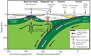
Forearc is a plate tectonic term referring to a region in a subduction zone between an oceanic trench and the associated volcanic arc. Forearc regions are present along convergent margins and eponymously form 'in front of' the volcanic arcs that are characteristic of convergent plate margins. A back-arc region is the companion region behind the volcanic arc.
A volcanic arc is a belt of volcanoes formed above a subducting oceanic tectonic plate, with the belt arranged in an arc shape as seen from above. Volcanic arcs typically parallel an oceanic trench, with the arc located further from the subducting plate than the trench. The oceanic plate is saturated with water, mostly in the form of hydrous minerals such as micas, amphiboles, and serpentines. As the oceanic plate is subducted, it is subjected to increasing pressure and temperature with increasing depth. The heat and pressure break down the hydrous minerals in the plate, releasing water into the overlying mantle. Volatiles such as water drastically lower the melting point of the mantle, causing some of the mantle to melt and form magma at depth under the overriding plate. The magma ascends to form an arc of volcanoes parallel to the subduction zone.

The geology of Australia includes virtually all known rock types, spanning a geological time period of over 3.8 billion years, including some of the oldest rocks on earth. Australia is a continent situated on the Indo-Australian Plate.
The Hunter-Bowen Orogeny was a significant arc accretion event in the Permian and Triassic periods affecting approximately 2,500 km of the Australian continental margin.

Magmatism is the emplacement of magma within and at the surface of the outer layers of a terrestrial planet, which solidifies as igneous rocks. It does so through magmatic activity or igneous activity, the production, intrusion and extrusion of magma or lava. Volcanism is the surface expression of magmatism.

A back-arc basin is a type of geologic basin, found at some convergent plate boundaries. Presently all back-arc basins are submarine features associated with island arcs and subduction zones, with many found in the western Pacific Ocean. Most of them result from tensional forces, caused by a process known as oceanic trench rollback, where a subduction zone moves towards the subducting plate. Back-arc basins were initially an unexpected phenomenon in plate tectonics, as convergent boundaries were expected to universally be zones of compression. However, in 1970, Dan Karig published a model of back-arc basins consistent with plate tectonics.

The geology of Turkey is the product of a wide variety of tectonic processes that have shaped Anatolia over millions of years, a process which continues today as evidenced by frequent earthquakes and occasional volcanic eruptions.

The Izu–Bonin–Mariana (IBM) arc system is a tectonic plate convergent boundary in Micronesia. The IBM arc system extends over 2800 km south from Tokyo, Japan, to beyond Guam, and includes the Izu Islands, the Bonin Islands, and the Mariana Islands; much more of the IBM arc system is submerged below sealevel. The IBM arc system lies along the eastern margin of the Philippine Sea Plate in the Western Pacific Ocean. It is the site of the deepest gash in Earth's solid surface, the Challenger Deep in the Mariana Trench.

The Mariana Trough is an active back-arc basin in the western Pacific Ocean. It is an integral part of the Izu–Bonin–Mariana Arc system.
The Sonoma orogeny was a period of mountain building in western North America. The exact age and structure of the Sonoma orogeny is controversial. The orogeny is generally thought to have occurred during the Permian / Triassic transition, around 250 million years ago, following the Late Devonian Antler orogeny. The Sonoma orogeny was one of a sequence of accretionary events along the Cordilleran margin, possibly caused by the closure of the basin between the island arc of Sonomia and the North American continent. Evidence of this event has been reported throughout western North America, but most distinctly in northwest Nevada.

The Sagami Trough also Sagami Trench, Sagami Megathrust, or Sagami Subduction Zone is a 340-kilometre (210 mi)long trough, which is the surface expression of the convergent plate boundary where the Philippine Sea Plate is being subducted under the Okhotsk Plate. It stretches from the Boso Triple Junction in the east, where it meets the Japan Trench, to Sagami Bay in the west, where it meets the Nankai Trough. It runs north of the Izu Islands chain and the Izu–Bonin–Mariana Arc (IBM).

The Mariana Plate is a micro tectonic plate located west of the Mariana Trench which forms the basement of the Mariana Islands which form part of the Izu–Bonin–Mariana Arc. It is separated from the Philippine Sea Plate to the west by a divergent boundary with numerous transform fault offsets. The boundary between the Mariana and the Pacific Plate to the east is a subduction zone with the Pacific Plate subducting beneath the Mariana. This eastern subduction is divided into the Mariana Trench, which forms the southeastern boundary, and the Izu–Ogasawara Trench the northeastern boundary. The subduction plate motion is responsible for the shape of the Mariana plate and back arc.

The Pacific Ocean evolved in the Mesozoic from the Panthalassic Ocean, which had formed when Rodinia rifted apart around 750 Ma. The first ocean floor which is part of the current Pacific Plate began 160 Ma to the west of the central Pacific and subsequently developed into the largest oceanic plate on Earth.
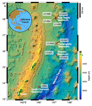
Mud volcanoes in the Mariana fore-arc are a hydrothermal geologic landform that erupt slurries of mud, water, and gas. There are at least 10 mud volcanoes in the Mariana fore-arc that are actively erupting, including the recently studied Conical, Yinazao, Fantagisna, Asut Tesoro, and South Chamorro serpentinite mud volcanoes. These mud volcanoes erupt a unique serpentinite mud composition that is related to the geologic setting in which they have formed. Serpentinite mud is the product of mantle metasomatism due to subduction zone metamorphism and slab dehydration. As a result, the serpentinite mud that erupts from these mud volcanoes often contains pieces of mantle peridotite material that has not fully altered during the serpentinization process. In addition to pieces of altered mantle material, pieces of subducted seamounts have also been found within the serpentinite muds. Serpentinite mud volcanoes in the Mariana fore-arc are often located above faults in the fore-arc crust. These faults act as conduits for the hydrated mantle material to ascend towards the surface. The Mariana mud volcanoes provide a direct window into the process of mantle hydration that leads to the production of arc magmas and volcanic eruptions.
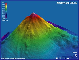
Eifuku and NW Eifuku (北西永福) are two seamounts in the Pacific Ocean. The better known one is NW Eifuku, where an unusual hydrothermal vent called "Champagne" produced droplets of liquid CO
2. Both seamounts are located in the Northern Marianas and are volcanoes, part of the Izu-Bonin-Mariana Arc. NW Eifuku rises to 1,535 metres (5,036 ft) depth below sea level and is a 9 kilometres (5.6 mi) wide volcanic cone.
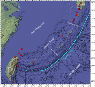
The Ryukyu Arc is an island arc which extends from the south of Kyushu along the Ryukyu Islands to the northeast of Taiwan, spanning about 1,200 kilometres (750 mi). It is located along a section of the convergent plate boundary where the Philippine Sea Plate is subducting northwestward beneath the Eurasian Plate along the Ryukyu Trench. The arc has an overall northeast to southwest trend and is located northwest of the Pacific Ocean and southeast of the East China Sea. It runs parallel to the Okinawa Trough, an active volcanic arc, and the Ryukyu Trench. The Ryukyu Arc, based on its geomorphology, can be segmented from north to south into Northern Ryukyu, Central Ryukyu, and Southern Ryukyu; the Tokara Strait separates Northern Ryukyu and Central Ryukyu at about 130˚E while the Kerama Gap separates Central Ryukyu and Southern Ryukyu at about 127 ˚E. The geological units of the arc include igneous, sedimentary, and metamorphic rocks, ranging from the Paleozoic to Cenozoic in age.

