Related Research Articles

Europa, or Jupiter II, is the smallest of the four Galilean moons orbiting Jupiter, and the sixth-closest to the planet of all the 95 known moons of Jupiter. It is also the sixth-largest moon in the Solar System. Europa was discovered independently by Simon Marius and Galileo Galilei and was named after Europa, the Phoenician mother of King Minos of Crete and lover of Zeus.

Cassini–Huygens, commonly called Cassini, was a space-research mission by NASA, the European Space Agency (ESA), and the Italian Space Agency (ASI) to send a space probe to study the planet Saturn and its system, including its rings and natural satellites. The Flagship-class robotic spacecraft comprised both NASA's Cassini space probe and ESA's Huygens lander, which landed on Saturn's largest moon, Titan. Cassini was the fourth space probe to visit Saturn and the first to enter its orbit, where it stayed from 2004 to 2017. The two craft took their names from the astronomers Giovanni Cassini and Christiaan Huygens.

A digital elevation model (DEM) or digital surface model (DSM) is a 3D computer graphics representation of elevation data to represent terrain or overlaying objects, commonly of a planet, moon, or asteroid. A "global DEM" refers to a discrete global grid. DEMs are used often in geographic information systems (GIS), and are the most common basis for digitally produced relief maps. A digital terrain model (DTM) represents specifically the ground surface while DEM and DSM may represent tree top canopy or building roofs.

Cloud cover refers to the fraction of the sky obscured by clouds on average when observed from a particular location. Okta is the usual unit for measurement of the cloud cover. The cloud cover is correlated to the sunshine duration as the least cloudy locales are the sunniest ones while the cloudiest areas are the least sunny places, as clouds can block sunlight, especially at sunrise and sunset where sunlight is already limited.

The Blue Marble is a photograph of Earth taken on December 7, 1972, by either Ron Evans or Harrison Schmitt aboard the Apollo 17 spacecraft on its way to the Moon. Viewed from around 29,400 km (18,300 mi) from Earth's surface, a cropped and rotated version has become one of the most reproduced images in history.
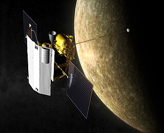
MESSENGER was a NASA robotic space probe that orbited the planet Mercury between 2011 and 2015, studying Mercury's chemical composition, geology, and magnetic field. The name is a backronym for "Mercury Surface, Space Environment, Geochemistry, and Ranging", and a reference to the messenger god Mercury from Roman mythology.

Venus Express (VEX) was the first Venus exploration mission of the European Space Agency (ESA). Launched in November 2005, it arrived at Venus in April 2006 and began continuously sending back science data from its polar orbit around Venus. Equipped with seven scientific instruments, the main objective of the mission was the long term observation of the Venusian atmosphere. The observation over such long periods of time had never been done in previous missions to Venus, and was key to a better understanding of the atmospheric dynamics. ESA concluded the mission in December 2014.

Deep Space Climate Observatory is a National Oceanic and Atmospheric Administration (NOAA) space weather, space climate, and Earth observation satellite. It was launched by SpaceX on a Falcon 9 v1.1 launch vehicle on 11 February 2015, from Cape Canaveral. This is NOAA's first operational deep space satellite and became its primary system of warning Earth in the event of solar magnetic storms.

NASA WorldWind is an open-source virtual globe. According to the website, "WorldWind is an open source virtual globe API. WorldWind allows developers to quickly and easily create interactive visualizations of 3D globe, map and geographical information. Organizations around the world use WorldWind to monitor weather patterns, visualize cities and terrain, track vehicle movement, analyze geospatial data and educate humanity about the Earth." It was first developed by NASA in 2003 for use on personal computers and then further developed in concert with the open source community since 2004. As of 2017, a web-based version of WorldWind is available online. An Android version is also available.

A polar ice cap or polar cap is a high-latitude region of a planet, dwarf planet, or natural satellite that is covered in ice.

Satellite images are images of Earth collected by imaging satellites operated by governments and businesses around the world. Satellite imaging companies sell images by licensing them to governments and businesses such as Apple Maps and Google Maps.

Landsat 5 was a low Earth orbit satellite launched on March 1, 1984, to collect imagery of the surface of Earth. A continuation of the Landsat Program, Landsat 5 was jointly managed by the U.S. Geological Survey (USGS) and the National Aeronautics and Space Administration (NASA). Data from Landsat 5 was collected and distributed from the USGS's Center for Earth Resources Observation and Science (EROS).
Google Earth is a web and computer program that renders a 3D representation of Earth based primarily on satellite imagery. The program maps the Earth by superimposing satellite images, aerial photography, and GIS data onto a 3D globe, allowing users to see cities and landscapes from various angles. Users can explore the globe by entering addresses and coordinates, or by using a keyboard or mouse. The program can also be downloaded on a smartphone or tablet, using a touch screen or stylus to navigate. Users may use the program to add their own data using Keyhole Markup Language and upload them through various sources, such as forums or blogs. Google Earth is able to show various kinds of images overlaid on the surface of the Earth and is also a Web Map Service client. In 2019, Google revealed that Google Earth now covers more than 97 percent of the world, and has captured 10 million miles of Street View imagery.

The plasmasphere, or inner magnetosphere, is a region of the Earth's magnetosphere consisting of low-energy (cool) plasma. It is located above the ionosphere. The outer boundary of the plasmasphere is known as the plasmapause, which is defined by an order of magnitude drop in plasma density. In 1963 American scientist Don Carpenter and Soviet astronomer Konstantin Gringauz proved the plasmasphere and plasmapause's existence from the analysis of very low frequency (VLF) whistler wave data. Traditionally, the plasmasphere has been regarded as a well behaved cold plasma with particle motion dominated entirely by the geomagnetic field and, hence, co-rotating with the Earth.

The exploration of Mercury has a minor role in the space interests of the world. It is the least explored inner planet. As of 2015, the Mariner 10 and MESSENGER missions have been the only missions that have made close observations of Mercury. MESSENGER made three flybys before entering orbit around Mercury. A third mission to Mercury, BepiColombo, a joint mission between the Japan Aerospace Exploration Agency (JAXA) and the European Space Agency, is to include two probes. MESSENGER and BepiColombo are intended to gather complementary data to help scientists understand many of the mysteries discovered by Mariner 10's flybys.

The climate of Mars has been a topic of scientific curiosity for centuries, in part because it is the only terrestrial planet whose surface can be easily directly observed in detail from the Earth with help from a telescope.

WorldWide Telescope (WWT) is an open-source set of applications, data and cloud services, originally created by Microsoft Research but now an open source project hosted on GitHub. The .NET Foundation holds the copyright and the project is managed by the American Astronomical Society and has been supported by grants from the Moore Foundation and National Science Foundation. WWT displays astronomical, earth and planetary data allowing visual navigation through the 3-dimensional (3D) Universe. Users are able to navigate the sky by panning and zooming, or explore the 3D universe from the surface of Earth to past the Cosmic microwave background (CMB), viewing both visual imagery and scientific data about that area and the objects in it. Data is curated from hundreds of different data sources, but its open data nature allows users to explore any third party data that conforms to a WWT supported format. With the rich source of multi-spectral all-sky images it is possible to view the sky in many wavelengths of light. The software utilizes Microsoft's Visual Experience Engine technologies to function. WWT can also be used to visualize arbitrary or abstract data sets and time series data.
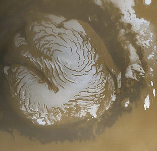
The planet Mars has two permanent polar ice caps of water ice and some dry ice (frozen carbon dioxide, CO2). Above kilometer thick layers of water ice permafrost slabs of dry ice are deposited during a pole's winter, lying in continuous darkness, causing 25–30% of the atmosphere being deposited annually at either of the poles. When the poles are again exposed to sunlight, the frozen CO2 sublimes. These seasonal actions transport large amounts of dust and water vapor, giving rise to Earth-like frost and large cirrus clouds.

The Suomi National Polar-orbiting Partnership, previously known as the National Polar-orbiting Operational Environmental Satellite System Preparatory Project (NPP) and NPP-Bridge, is a weather satellite operated by the United States National Oceanic and Atmospheric Administration (NOAA). It was launched in 2011 and is currently in operation.
Planet Labs PBC is a publicly trading American Earth imaging company based in San Francisco, California. Their goal is to image the entirety of the Earth daily to monitor changes and pinpoint trends.
References
- ↑ Simmon, Robert. "My Favorites". earthobservatory.nasa.gov. Retrieved 2020-07-29.
- 1 2 "NASA - Robert Simmon - AKA Mr. Blue Marble". www.nasa.gov. Retrieved 2020-03-29.
- 1 2 3 4 5 6 Yanofsky, David. "The guy who created the iPhone's Earth image explains why he needed to fake it". Quartz. Retrieved 2020-03-29.
- ↑ Ogburn, Stephanie Paige (August 15, 2013). "People: How NASA's Robert Simmon makes climate science beautiful". www.eenews.net. Retrieved 2020-03-29.