The town lies on Cape Mount peninsula, a spit of land separating the brackish lagoon Lake Piso from the Atlantic Ocean,[2]50mi (80km) north-west of Monrovia. It serves as the capital of Grand Cape Mount County and is the home of the city corporation.[3]
History
In the mid-15th century, the Portuguese navigator Pedro de Sintra reached the cape, a 1,000-foot high granite promontory, which he named Cabo do Monte (Cape Mount).[1] Cape Mount was the site of Dutch trading post, which turned out to be very hard to defend. The post never became self-sufficient, and habitually required assistance from the station at Elmina, about 750 miles away by sea.[4]Théodore Canot, a writer and slave-trader, established a settlement in the area in 1840.[5] In 1849 the Liberian government signed a treaty with the Vai people,[1] acquiring the territory of Cape Mount and subsequently founding Robertsport in 1856.[5]
Robertsport used to host the Tubman Center of African Culture, which was built in 1964 to commemorate William V.S. Tubman's sixty-ninth birthday.[6] The institution was meant to be a world-wide center of research,[7] and to support and promote African studies.[6] The civil war destroyed the structure, and only the ruins remain.[8]
Since the Second Liberian Civil War, the town, still mostly a fishing village, is being developed as a seaside resort for surfing. American visitors coming to the area after 2003 met up with a local, Robert Lomax, whom they taught to surf. Lomax taught others how to surf, including Philip Banini, who became a surfing teacher and owner of a guesthouse for surfers. As of 2022[update], the Robertsport Surf Club was expected to start owning its own beach property for surfing lessons and fishing trips.[9] The film “We The Surfers” about the annual African national Surfing titles held in Robertstown and it’s participants including women surfers Faith and Butterfly from Robertstown was showcased at the Ocean Film Festival 2025.
Geography
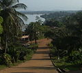
Aerial shot of Robertsport Beach and Nana's Lodge
Robertsport's coast contains a series of left-hand point breaks that are internationally recognized by surfers. The main breaks commonly identified in travel literature and by local surfers include Fisherman’s Point, Cotton Trees, Cassava Point, Camp Point and Cutting Point. Conditions vary seasonally, and different sources use slightly different naming conventions, but most describe Robertsport as having five to six distinct point breaks along its curved shoreline.[10]
Robertsport has a tropical monsoon climate (KöppenAm) with a short dry season from January to March and a long, persistent wet season covering the rest of the year. At the peak of the wet season from July to September rainfall is exceedingly heavy, with monthly averages of around 35 inches or 900 millimetres.
As of the 2008 census, Robertsport has a population of 3,933. Of this, 1,994 were male and 1,939 female.[12] Robertsport was founded in 1856 as a settlement for recently arrived African American immigrants. The Vai are the dominant indigenous ethnic group, but other groups are present as well, notably the Gola, Mende, Mandingo, Fante, Klao [Kru], and Bassa.
Administration and government
Local government and representation
Robertsport is administered as the Robertsport City Corporation, headed by a city mayor and city council in accordance with Liberia’s City Ordinance Law.[13] As of 2024, communications from the Robertsport City Corporation identify Thomas Bai Massaquoi Sr. as the city’s mayor.[14]
At the county level, Grand Cape Mount County is overseen by a superintendent appointed by the national government. Recent official and partner reports name Folley (Foday) J. Kiatamba as County Superintendent.[15][16]
Grand Cape Mount County is represented at the national level by two senators and several members of the House of Representatives. Recent sources list Simeon Boima Taylor and Amara Mohammed Konneh as the county’s senators, with Mohammed Dosii among its elected representatives.[17][18]
Robertsport serves as the administrative seat of Grand Cape Mount County and hosts the offices of the county administration and the Commonwealth District authorities. The town’s local government is led by a city corporation, which manages municipal services, local regulations and coordination with national ministries.[19]
Health care
Robertsport is served by St. Timothy Government Hospital, the primary public referral hospital for Grand Cape Mount County. National health-sector documents identify it as the only hospital in the county, supported by a network of clinics and two health centers administered through the county health team.[20][21]
According to partner organizations working with the Ministry of Health, St. Timothy has slightly more than forty inpatient beds, a single operating room, an outpatient clinic and a staff composed of Liberian physicians, physician assistants, midwives and nurses. The facility serves as the main referral point for an estimated 135,000 residents of Grand Cape Mount County, with serious cases transported onward to hospitals in Monrovia.[22]
Improvement projects in recent years have included the installation of upgraded laboratory equipment, construction of a small emergency room, and the provision of solar power through a United Nations Development Programme initiative aimed at strengthening energy access in health facilities.[23][24] An additional ambulance has also been supplied to support emergency referrals between Robertsport, surrounding communities and the county’s hinterland.[25]
A 2016–2018 assessment of water, sanitation and hygiene conditions in Liberian health facilities reported that St. Timothy met national and World Health Organization minimum standards for environmental health, following upgrades to its water and waste-management systems.[26]
Economy
Liberia is a war torn country. Despite looting, the town has remained structurally intact. The town's architecture includes now-decrepit, plantation-style houses reminiscent of the Southern United States - a historical influence on Liberia - which line wide avenues that lean against the hills on the town's edge.[10]
Robertsport residents are mainly rice farmers and fishermen,[1] with 30% of the population engaging in fishing.[27]
Tourism and surfing
Since the end of the civil war, Robertsport has remained primarily a fishing community while gradually developing a small but growing tourism sector centered on surfing. International media and travel writers have highlighted the town’s long, left-hand point breaks, uncrowded beaches and low degree of commercial development.[28][29] Travel guides describe the area as a “hidden gem,” attracting both domestic visitors and a small number of international surfers.[30]
Robertsport hosts several small beach lodges, guesthouses and surf camps, such as Nana’s Lodge, Kwepunha Surf Retreat, Philip’s Guesthouse, Vartilda Beach Guest House, the Robertsport Surf Club and the nearby Warkolor Jungle Lodge & Reserve. These lodgings provide basic services for surfers and visitors, with facilities ranging from tents and beach cabins to simple guest rooms.[31]
Surfing has also become a focus for youth engagement and local development. The Robertsport Surf Club and the Grand Cape Mount Surf Association work with organizations such as the Universal Outreach Foundation and Provide the Slide to offer surfboards, swimming instruction, ocean-safety training and educational support to local youth.[32][33] Supported by donors, the surf club has developed modest tourism infrastructure at Fisherman’s Point, including solar-powered facilities, a small restaurant, camping platforms and a clubhouse.
Robertsport and the Lake Piso area have been identified by national authorities and international partners as priority sites for ecotourism development. Initiatives under the Enhanced Integrated Framework and the International Trade Centre have supported basic tourism planning, marketing and small-scale infrastructure improvements linked to surfing and nature-based activities.[34] Despite its highly regarded waves, travel writers note that road conditions and limited services continue to constrain the scale of tourism. However, as of 2025 Liberia has implemented a new electronic Visa-on-Arrival and e-Visa system, which simplifies entry requirements for international travellers.[35][36][37]
In popular culture
Robertsport has been featured in several surf-related films. The documentary Sliding Liberia (2009) follows four surfers traveling through Liberia shortly after the civil war and includes scenes filmed in the Robertsport area. Another film, We The Surfers (2025), documents competitors in the African National Surfing Titles held in Robertsport and was screened at the Ocean Film Festival 2025.[38]
↑Girma, Kidane (1982). "The National Museum: Liberia - (mission)". Participation and Cooperation for Development Programmes and International Campaigns. 4. UNESCO: 3. Retrieved 18 February 2019.
This page is based on this Wikipedia article Text is available under the CC BY-SA 4.0 license; additional terms may apply. Images, videos and audio are available under their respective licenses.