Robinson's Ferry (boat)

Last updated
Robinson's Ferry
USA California location map.svg
Red pog.svg
Location of Robinson's Ferry in California
Usa edcp location map.svg
Red pog.svg
Robinson's Ferry (boat) (the United States)
Location Angels Camp, California
Coordinates 38°00′32″N120°30′17″W / 38.0089277°N 120.5046527°W / 38.0089277; -120.5046527
Built1848
Reference no.276

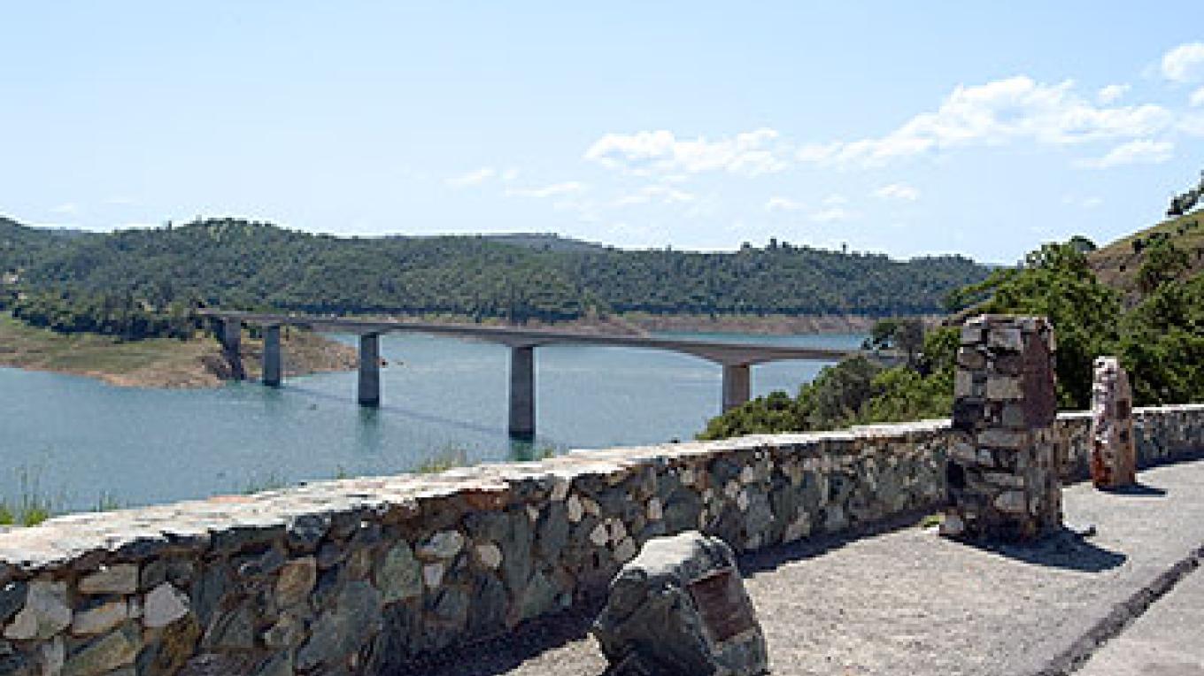
Robinson's Ferry is a historical site in Angels Camp, California in Calaveras County. John W. Robinson and Stephen Mead founded a ferry in 1848. The ferry crossed the river, where New Melones Lake is now. The New Melones Lake Bridge now crosses where the ferry was. The ferry was used to move California Gold Rush miners, their cargo and animals across the river. Harvey Wood purchased the ferry in 1856. The fare to cross was 50 cents for each person or animal crossing. The site of Robinson's Ferry a California Historical Landmark No. 276. [1] A marker is on California State Route 49 near the bridge across New Melones Lake. The historical marker was placed there in 1949 by California Centennial Commission, and the base was built Angels Camp Lions Club. The Marker is 5.6 miles south of Angels Camp and 0.3 miles north of New Melones Lake Reservoir. [2] [3]

Contents

See also

Related Research Articles

<span class="mw-page-title-main">Calaveras County, California</span> County in California, United States

Calaveras County, officially the County of Calaveras, is a county in both the Gold Country and High Sierra regions of the U.S. state of California. As of the 2020 census, the population was 45,292. The county seat is San Andreas. Angels Camp is the county's only incorporated city. Calaveras is Spanish for "skulls"; the county was reportedly named for the remains of Native Americans discovered by the Spanish explorer Captain Gabriel Moraga.

<span class="mw-page-title-main">Angels Camp, California</span> City in California, United States

Angels Camp, also known as City of Angels and formerly Angel's Camp, Angels, Angels City, Carson's Creek and Clearlake, is the only incorporated city in Calaveras County, California, United States. The population was 3,836 at the 2010 census, up from 3,004 at the 2000 census. It lies at an elevation of 1378 feet.

<span class="mw-page-title-main">California State Route 49</span> Highway in California

State Route 49 is a north–south state highway in the U.S. state of California that passes through many historic mining communities of the 1849 California gold rush and it is known as the Golden Chain Highway. The highway's creation was lobbied by the Mother Lode Highway Association, a group of locals and historians seeking a single highway to connect many relevant locations along the Gold Rush to honor the 49ers. One of the bridges along SR 49 is named for the leader of the association, Archie Stevenot.

Historic ferries operated on rivers around Atlanta, Georgia area, and became namesakes for numerous current-day roads in north Georgia. Most of the ferries date to the early years of European-American settlement in the 1820s and 1830s, when parts of the region were still occupied by cherokee and other Native American communities.

<span class="mw-page-title-main">Stanislaus River</span> River in north-central California, US

The Stanislaus River is a tributary of the San Joaquin River in north-central California in the United States. The main stem of the river is 96 miles (154 km) long, and measured to its furthest headwaters it is about 150 miles (240 km) long. Originating as three forks in the high Sierra Nevada, the river flows generally southwest through the agricultural San Joaquin Valley to join the San Joaquin south of Manteca, draining parts of five California counties. The Stanislaus is known for its swift rapids and scenic canyons in the upper reaches, and is heavily used for irrigation, hydroelectricity and domestic water supply.

Melones is a former settlement in Calaveras County, California, now submerged beneath a reservoir named New Melones Lake. It lay at an elevation of 955 feet. Melones was founded on the site of a ferry operated from 1848 by John W. Robinson and Stephen Mead. The town initially took its name from the ferry.

<span class="mw-page-title-main">New Melones Lake</span> Reservoir in California, USA

New Melones Lake is a reservoir on the Stanislaus River in the central Sierra Nevada foothills, within Calaveras County and Tuolumne County, California.

<span class="mw-page-title-main">Mojave Road</span> Historical trails and roads

The Mojave Road, also known as Old Government Road, is a historic route and present day dirt road across what is now the Mojave National Preserve in the Mojave Desert in the United States. This rough road stretched 147 miles (237 km) from Beale's Crossing, to Fork of the Road location along the north bank of the Mojave River where the old Mojave Road split off from the route of the Old Spanish Trail/Mormon Road.

<span class="mw-page-title-main">Blythe Ferry</span> United States historic place

Blythe Ferry was a ferry across the Tennessee River in Meigs County, Tennessee, United States. In 1838, the ferry served as a gathering point and crossing for the Cherokee Removal, commonly called the Trail of Tears, in which thousands of Cherokee were forced to move west to Oklahoma from their homeland in the southeastern United States.

<span class="mw-page-title-main">Emigrant Trail in Wyoming</span> 19th century pioneer route in western United States

The Emigrant Trail in Wyoming, which is the path followed by Western pioneers using the Oregon, California, and Mormon Trails, spans 400 miles (640 km) through the U.S. state of Wyoming. The trail entered from Nebraska on the eastern border of the state near the present day town of Torrington and exited on the western border near the towns of Cokeville and Afton. An estimated 350,000 to 400,000 settlers traveled on the trail through Wyoming between 1841 and 1868. All three trails follow the same path through most of the state. The Mormon Trail splits at Fort Bridger and enters Utah, while the Oregon and California Trails continue to Idaho.

Robinson's Ferry may refer to:

Gordon's Ferry is both a geographical location and a historic site in Bakersfield, California. It is located where China Grade Loop crosses the Kern River and meets with Alfred Harrell Highway in Northeast Bakersfield. It is named after a ferry that used to cross the river near the existing bridge. It was one of the only eastern crossings, until 1877, when the Jewett Avenue bridge was constructed farther west. It is California Historical Landmark #137.

The Stockton–Los Angeles Road, also known as the Millerton Road, Stockton–Mariposa Road, Stockton–Fort Miller Road or the Stockton–Visalia Road, was established about 1853 following the discovery of gold on the Kern River in Old Tulare County. This route between Stockton and Los Angeles followed by the Stockton–Los Angeles Road is described in "Itinerary XXI. From Fort Yuma to Benicia, California", in The Prairie Traveler: A Hand-book for Overland Expeditions by Randolph Barnes Marcy. The Itinerary was derived from the report of Lieutenant R. S. Williamson on his topographical survey party in 1853, that was in search of a railroad route through the interior of California.

<span class="mw-page-title-main">Camp Cady</span> Historic site in Miles N of Barstow, California

Camp Cady was a U.S. Army Camp, on the Mojave Road near the Mojave River in the Mojave Desert, located about 20 miles east of modern-day Barstow, California in San Bernardino County, at an elevation of 1690 feet. Camp Cady was named after Major Albemarle Cady, 6th Infantry Regiment, who was a friend of Carleton and commander at Fort Yuma in 1860.

The Byrne's Ferry bridge was a historic cantilevered covered bridge across the Stanislaus River between Calaveras County and Tuolumne County, California. Originally built during the California Gold Rush, the bridge was located on the O'Byrne's Ferry road between Chinese Camp and Copperopolis. Until the mid-20th century, it was one of the last remaining covered bridges in the state; the bridge was destroyed in 1957 to make way for the construction of Tulloch Dam.

<span class="mw-page-title-main">Mojave Road (Los Angeles)</span> California Historic Landmark

The Mojave Road Los Angeles was designated a California Historic Landmark on March 19, 1985. It runs from Drum Barracks in Los Angeles County to the Colorado River in San Bernardino County, California.

<span class="mw-page-title-main">Big Bar (Amadour County, California)</span> Gold mine in California, United States

The Big Bar, also called Upper Bar, is a gold mine in Jackson, California, United States. The mine opened in 1848 along the Mokelumne River and is registered as California Historical Landmark #41.

The site of the Old Mining Camp of Brownsville is a California Historical Landmark on Pennsylvania Gulch Road east of the town of Murphys, California in Calaveras County. The Mining Camp of Brownsville was a California Gold Rush camp in Pennsylvania Gulch in from 1850 to 1870. The camp is named after Alfred Brown, who was the former owner of the Table Mountain Ranch. There were many rich mines in the area and Brownsville Mining Camp supported this activity. So rich was the area, the Brownsville Mining District limited the size of mines in the District. Each miner could claim and own only one wet and one dry site, no larger than 150 square feet each. Brownsville Mining District was in the area of Pennsylvania Gulches and Missouri Gulches 2 miles from Murphys. There are no remains of the camp, but nearby is the Brownsville Mining District Cemetery. A plaque monument was dedicated on July 19, 1953, by California State Park Commission with the monument base built by Christa Parlor No. 137 and Ruby Parlor No. 49 of the Native Daughters of the Golden West.

Prince-Garibaldi Building is a historical building in Altaville, California in Calaveras County. Altaville, California is just north of the twon of Angels Camp. The building was built by B. R. Prince and G. Garibardi in 1852 as a general store on the first floor. The building is built built by David Strosberger out of rhyolite tuff stones designed. In 1857 a second floor was added and used for the store owner's living space. For a time the building was the Prince Undertaking Parlor with a plumed horse hearse. The Prince-Garibaldi Building is a California Historical Landmark No. 735 of California State Route 49.

References