Adams County is a county located in the U.S. state of Mississippi. As of the 2020 census, the population was 29,538. The county seat is Natchez.

Webster County is a county located in center of the U.S. state of Mississippi, bordered on the south by the Big Black River. As of the 2020 census, the population was 9,926.

Oktibbeha County is a county in the east central portion of the U.S. state of Mississippi. As of the 2020 census the population was 51,788. The county seat is Starkville. The county's name is derived from a local Native American word meaning either "bloody water" or "icy creek". The Choctaw had long occupied much of this territory prior to European exploration and United States acquisition.

Madison County is a county located in the U.S. state of Mississippi. As of the 2020 census, the population was 109,145. The county seat is Canton. The county is named for Founding Father and U.S. President James Madison.

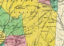
The Natchez Trace, also known as the Old Natchez Trace, is a historic forest trail within the United States which extends roughly 440 miles (710 km) from Nashville, Tennessee, to Natchez, Mississippi, linking the Cumberland, Tennessee, and Mississippi rivers.
Charley's Trace is a former Native American trail to the Mississippi River.

The Natchez Trace Parkway is a national parkway in the Southeastern United States that commemorates the historic Natchez Trace and preserves sections of that original trail. Its central feature is a two-lane road that extends 444 miles (715 km) from Natchez, Mississippi, to Nashville, Tennessee. Access to the parkway is limited, with more than 50 access points in Mississippi, Alabama, and Tennessee. The southern end of the route is in Natchez at its intersection with Liberty Road, and the northern end is northeast of Fairview, Tennessee, in the suburban community of Pasquo, at an intersection with Tennessee State Route 100. In addition to Natchez and Nashville, larger cities along the route include Jackson and Tupelo, Mississippi, and Florence, Alabama.


The Gaines Trace was a road in the Mississippi Territory. It was constructed in 1811 and 1812 from the Tennessee River to Cotton Gin Port on the upper Tombigbee River and on to Fort Stoddert on the lower Tombigbee. The portion from the Tennessee River to Cotton Gin Port was surveyed in 1807 and 1808 by Edmund P. Gaines, the road's namesake and a career United States Army officer.

Mississippi Highway 12 is a state highway in northern Mississippi that runs 198.7 miles (319.8 km) west–east from MS 1 west of Hollandale at the Mississippi River to State Route 18 at the Alabama state line northeast of Columbus. MS 12 traverses three major regions of the state, the Mississippi Delta, the North Central Hills, and the Golden Triangle.

The Golden Triangle (GTR) is a region in the east central portion of the U.S. state of Mississippi. The "triangle" is formed by the cities of Columbus, Starkville, and West Point but the region is often more broadly-defined to include all of Clay, Lowndes, and Oktibbeha counties and sometimes additional surrounding communities and counties as well. The term was used as a marketing strategy in the 1960s to promote economic development in the region and encourage additional cooperation between local communities in attracting investment, although the term was in use by 1939.

Mississippi Highway 555 is a state highway in southwestern Mississippi. The route has two sections, both in Adams County. The first section starts at Ogden Road and travels northwestward to its terminus at US 61. The second section starts at the concurrency of MS 930 and MS 932 and the concurrency of US 61 and US 84 in Natchez. MS 555 travels northward through Pine Ridge and ends at Anna's Bottom Road near the Anna site. The route travels by a few historical locations, including the Pine Ridge Presbyterian Church.

Jackson's Military Road was a 19th-century route connecting Nashville, Tennessee, with New Orleans, Louisiana. After the War of 1812, Congress appropriated funds in 1816 to build and improve this road. It was completed in 1820. The road was named for then General Andrew Jackson, hero of the United States victory at the Battle of New Orleans against British forces.

Oktoc is an unincorporated community in Oktibbeha County, Mississippi. Once known as "The Dairy Capital of the South," Oktoc is now home to several defunct dairy farms including Oak Ayr and Mactoc Farms, the largest two in the community. Oktoc has the oldest community club in the state and has not missed a meeting since its beginning in 1927.
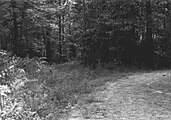
Seven segments of the historic Natchez Trace are listed on the National Register of Historic Places (NRHP). Also there are additional NRHP-listed structures and other sites along the Natchez Trace, which served the travelers of the trace and survive from the era of its active use.
Selsertown is an extinct town in Adams County, Mississippi, United States.
Agency is a ghost town located in Oktibbeha County, Mississippi, United States.

Pigeon Roost is a ghost town in Choctaw County, Mississippi.
Nashville is a ghost town in Lowndes County, Mississippi, United States.

Mississippi Highway 389 is a state highway that runs from south to north in the U.S. State of Mississippi. MS 389 currently exists in two sections. The southern section begins at MS 182 in Starkville. The road travels north out of the city, and crosses U.S. Route 82 and MS 15. North of Starkville, the route continues northwestwards and ends at the Oktibbeha–Clay county line south of Pheba. The northern section starts at MS 46 west of Montpelier, and it travels north to cross the Natchez Trace Parkway in Chickasaw County. MS 389 ends at MS 8 in Houston.