
Owsley County is a county located in the Eastern Coalfield region of the U.S. state of Kentucky. As of the 2020 census, the population was 4,051, making it the second-least populous county in Kentucky. The county seat is Booneville. The county was organized on January 23, 1843, from Clay, Estill, and Breathitt counties and named for William Owsley (1782–1862), the judge of the Kentucky Court of Appeals and Governor of Kentucky (1844–48). According to the 2010 census reports, Owsley County has the second-highest level of child poverty of any county in the United States. In terms of income per household, the county is the poorest in the nation. Between 1980 and 2014, the rate of death from cancer in the county increased by 45.6 percent, the largest such increase of any county in the United States.

Clifton is the largest city in Bosque County, in Central Texas in the United States. The city's population was 3,442 at the 2010 census.
Denver, formerly known as Dry Pond, is a census-designated place and unincorporated community in Lincoln County, North Carolina, United States. As of the 2010 census it had a population of 2,309.
Pollok is an unincorporated community in Angelina County, Texas, United States. According to the Handbook of Texas, the community had a population of 300 in 2000. It is located within the Lufkin, Texas micropolitan area.

Edwardsburgh/Cardinal is a township in the United Counties of Leeds and Grenville of eastern Ontario, Canada. Edwardsburgh township was first surveyed in 1783, and incorporated in 1850. The township was part of the historical Grenville County before it merged with Leeds County to form the United Counties in the 19th century.
Cayuga is an unincorporated community in northwestern Anderson County, Texas, United States. According to the Handbook of Texas, the community had a population of 200 in 2000. It is located within the Palestine, Texas micropolitan area.

A Friends meeting house is a meeting house of the Religious Society of Friends (Quakers), where meeting for worship is usually held.

Huckabay is an unincorporated community located at the intersection of State Highway 108 and Farm Road 219, ten miles northwest of Stephenville in Erath County, Texas, United States. It had a population of approximately 150 in 2000.

The Old Scotch Church, also known as the Tualatin Plains Presbyterian Church, is a church and national historic site located in an unincorporated part of Washington County, Oregon, near Hillsboro, Oregon, United States. The church dates to 1873 while the church structure with an eight-sided steeple dates to 1878. A cemetery on the church grounds holds the graves of church members and local pioneer settlers of the Tualatin Plains, including Joseph Meek.
Turnersville is an unincorporated community in Coryell County, Texas, United States, approximately 40 miles (64 km) west of Waco and 12 miles (19 km) north-northeast of Gatesville. As of 2004, the estimated population was 350.
Doss is an unincorporated farming and ranching community at the crossroads juncture of FM 783 and FM 648 in northwestern Gillespie County, Texas, United States. It is 19 miles NW of Fredericksburg and 14 miles NE of Harper. Postal zip code is 78618. Elevation is 1729 feet.
Montalba is an unincorporated community in central Anderson County, Texas, United States. According to the Handbook of Texas, the community had a population of 809 in 2019. It is located within the Palestine, Texas micropolitan area.
Brandon is an unincorporated community located in Hill County in Central Texas. It is located at the intersection of State Highway 22 and FM 1243, approximately ten miles east of Hillsboro.
Bethany is an unincorporated community in Baker County, Georgia, United States.
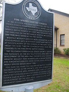
Pine Springs is an unincorporated community, also called Fruit, on U.S. 271 just north of Tyler, Texas in central Smith County, Texas. In 2000 the population was 150 residents.
Bethel is an unincorporated community in Anderson County, located in the U.S. state of Texas. According to the Handbook of Texas, 50 people lived in the community in 2000. It is a part of the Palestine, Texas micropolitan area.
Norse is an unincorporated community in Bosque County, Texas, United States. According to the Handbook of Texas, the community had a population of 110 in 2000.

Peyton is an unincorporated community in Blanco County, in the U.S. state of Texas. According to the Handbook of Texas, the community had a population of 30 in 2000.
Joe Lee is an unincorporated community in Bell County, in the U.S. state of Texas. According to the Handbook of Texas, only 2 people lived in the community in 2000. It is located within the Killeen-Temple-Fort Hood metropolitan area.
Smith Bend is an unincorporated community in Bosque County, in the U.S. state of Texas.


