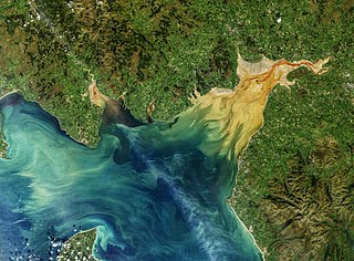
The Solway Firth is a firth that forms part of the border between England and Scotland, between Cumbria and Dumfries and Galloway. It stretches from St Bees Head, just south of Whitehaven in Cumbria, to the Mull of Galloway, on the western end of Dumfries and Galloway. The Isle of Man is also very near to the firth. The firth comprises part of the Irish Sea.

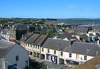
Dumfries is a market town and former royal burgh in Dumfries and Galloway, Scotland, near the mouth of the River Nith on the Solway Firth, 25 miles (40 km) from the Anglo-Scottish border. Dumfries is the county town of the historic county of Dumfriesshire.

Dumfries and Galloway is one of the 32 unitary council areas of Scotland, located in the western part of the Southern Uplands. It is bordered by East Ayrshire, South Ayrshire, and South Lanarkshire to the north; Scottish Borders to the north-east; the English ceremonial county of Cumbria, the Solway Firth, and the Irish Sea to the south, and the North Channel to the west. The administrative centre and largest settlement is the town of Dumfries. The second largest town is Stranraer, located 76 miles (122 km) to the west of Dumfries on the North Channel coast.
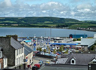
Stranraer is a town in Dumfries and Galloway, Scotland, on Loch Ryan and the northern side of the isthmus joining the Rhins of Galloway to the mainland. Stranraer is Dumfries and Galloway's second-largest town, with a population of nearly 13,000.

Castle Douglas is a town in Dumfries and Galloway, Scotland. It lies in the lieutenancy area of Kirkcudbrightshire, in the eastern part of Galloway, between the towns of Dalbeattie and Gatehouse of Fleet. It is in the ecclesiastical parish of Kelton.
Whithorn, is a royal burgh in the historic county of Wigtownshire in Dumfries and Galloway, Scotland, about 10 miles (16 km) south of Wigtown. The town was the location of the first recorded Christian church in Scotland, Candida Casa 'White/Shining House', built by Saint Ninian about 397.

Gatehouse of Fleet is a town, half in the civil parish of Girthon, and half in the parish of Anwoth, divided by the river Fleet, Kirkcudbrightshire, within the council administrative area of Dumfries and Galloway, Scotland.

Parton is a hamlet situated on the banks of the River Dee in the historical county of Kirkcudbrightshire, Dumfries and Galloway, Scotland.

Kippford is a small village along the Solway coast, in the historic county of Kirkcudbrightshire in Dumfries and Galloway, Scotland. Also known as the Solway Riviera and has the most expensive property in Dumfries & Galloway.

Urr Water or River Urr is a river which flows through the counties of Dumfriesshire and Kirkcudbrightshire in southwest Scotland.
Mochrum is a coastal civil and Church of Scotland parish situated to the east of Luce Bay on the Machars peninsula and 8 miles (13 km) southwest of Wigtown and in the historical county of Wigtownshire in Galloway, Scotland. It covers 22,000 acres (8,900 ha) and is approximately 10 miles (16 km) in length and 5 miles (8.0 km) in breadth. The parish contains the eponymous village of Mochrum, as well as Port William and the clachan of Elrig.
Glasserton is a civil parish in Dumfries and Galloway, south-west Scotland. It is on the Machars peninsula, in the traditional county of Wigtownshire. The parish is about 8 miles (13 km) in length, varying in breadth from 1 to 3 miles, and contains 13,477 acres (54.54 km2).

The Diocese of Galloway is a Latin Church ecclesiastical territory or diocese of the Catholic Church in Scotland. The pre-Reformation Diocese of Galloway, founded by Ninian in the fifth century, had broken allegiance with Rome in 1560, and disappeared in 1689 in the (official) Church of Scotland but continued in the Episcopal Church of Scotland. The modern Roman Catholic diocese incorporates the local authority areas of Dumfries and Galloway, South Ayrshire, East Ayrshire and parts of North Ayrshire, (Cumbrae). The bishop's cathedra is at St Margaret's Cathedral, Ayr.

Kirkcowan is an area about 15 miles in length, and from nearly two to nearly seven miles in breadth, comprising 30,580 acres, of which 7000 are arable, 300 woodland and plantations, and the remainder meadow, pasture in Machars, in the historical county of Wigtownshire, in Dumfries and Galloway, Scotland, with the village of Kirkcowan, bounded on the east by the river Bladnoch, on the west by the river Tarff, and is 6 miles W. by S.W. from Newton Stewart.
Stoneykirk is an area and a village in the heart of the Rhins of Galloway, Wigtownshire, in the administrative council area of Dumfries and Galloway, Scotland nearly 10 miles (16 km) in length and 3+1⁄2 miles (5.6 km) in breadth, bounded on the east by the bay of Luce, and on the west by the Irish Channel, 5 miles (8 km) south of Stranraer.

Crossmichael is a small village on the east side of Loch Ken in the historical county of Kirkcudbrightshire, about 4 miles (6.4 km) north of Castle Douglas in Scotland.
Rough Firth is an inlet on the northern coast of the Solway Firth in the Stewartry area of Dumfries and Galloway, Scotland. The firth lies between Almorness Point and Castlehill Point, and contains Rough Island. The village of Kippford stands near the head of the firth where the Urr Water reaches the sea; the only other coastal settlement of any size is Rockcliffe. The area is designated as the East Stewartry Coast National Scenic Area, one of the forty national scenic areas (NSAs) in Scotland.
Leswalt is a village and civil parish in Dumfries and Galloway, south-west Scotland. It lies between Portpatrick and Stranraer in the Rhins of Galloway, part of the traditional county of Wigtownshire. The parish covers around 8 square miles (21 km2).
Inch is a civil parish in Dumfries and Galloway, southwest Scotland. It lies on the shore of Loch Ryan, in the traditional county of Wigtownshire.
Old Luce is a civil parish in Dumfries and Galloway, Scotland. It lies in the Machars peninsula, in the traditional county of Wigtownshire. The parish is around 10 miles (16 km) long and 8 miles (13 km) broad, and contains 40,350 acres (16,330 ha).


