Roman Dam of Belas

Last updated
Roman Dam of Belas
Barragem romana Belas1.JPG
Part of the Roman dam complex, showing the ventilation structures (foreground) and the remaining dam segment (background)
Official nameBarragem Romana de Belas
Country Portugal
Location Queluz e Belas, Lisbon
Coordinates 38°47′35.6″N9°14′40.2″W / 38.793222°N 9.244500°W / 38.793222; -9.244500 Coordinates: 38°47′35.6″N9°14′40.2″W / 38.793222°N 9.244500°W / 38.793222; -9.244500
Opening date3rd century
Operator(s)Companhia das Águas de Lisboa
Dam and spillways
Height (foundation)8 m (26 ft)
Length15.5 m (51 ft)

The Roman Dam of Belas (Portuguese : Barragem Romana de Belas) is a 3rd-century Roman barrier constructed to serve the city of Olisipo, located in civil parish of Queluz e Belas, municipality of Sintra (in the Portuguese district of Lisbon). [1]

Contents

History

The dam was constructed in the 3rd century, although it is unclear when it was abandoned. [2]

In 1571, Francisco de Holanda first identified the dam and fountains constructed in Lisbon (in Da Fábrica que falece a citada de Lisboa). [2] [3] Holanda, an exponent of the Portuguese Renaissance, painter and humanist, designed the dam and the fountains that were built in the Portuguese capital, then suggesting that they be used reused to bring water to the city. [3] This was typical of the posture of someone who had interned in Rome, promoted by the policies of King John III (1502- 1557), that contemplated his cultural scholarship in Europe. [3] During this period Holanda was motivated by the rediscovery and elevation of the classical antiquity, whose testaments in Italy had influenced the principal courts of Europe. [3]

In a regal letter (dated 1573) King Sebastian recommended that they conclude whatever steps were necessary to bring water to Lisbon, but little was concluded. [2]

In 1619, King Philip III of Spain visited the old dam with the intention of promoting its reconstruction, under the direction of Leonardo Turriano. [2] Within the year there was a letter from Madrid with report and four projects established to bring water to Lisbon, with the best being the Roman aqueduct. [2] Taxes were established in order to cost the public works. But, in 1623, a letter determined that the taxes would be used to assist overseas Indian territories. [2]

In 1728, construction began on a new aqueduct that devastated part of the Roman in the area of "crags" because the dam was seen as unnecessary, given the abundance of possible sources of capture in the basin. [2] The smaller buildings erected there, the ventilators are still maintained by the Companhia das Águas de Lisboa. [2]

The construction of the Caneças-Lisbon roadway resulted in the destruction and burial of another wall of the dam. [2]

Architecture

The remnants of the dam are located in a rural place, implanted alongside and below the roadway, along the Carenque River, partially covered by forest and medium vegetation, situated 10 kilometres (33,000 ft) from the city centre. [2]

The ancient ruins of the dam are survived by a central segment some 15.5 metres (51 ft) long, 8 metres (26 ft) tall and 7 metres (23 ft) wide, and reinforced by three buttresses. [2]

It extends in the local occupied by roadway and the other end to the lateral of the valley, where a great part of the wall was destroyed. [2] The reservoir created by the dam warehoused approximately 125 cubic metres (4,400 cu ft) of water. [2] The channel from the structure extends 1,300 metres (4,300 ft) and is visible as it still intersects the more modern Águas Livres Aqueduct that was built over the old structures. [2]

See also

Related Research Articles

Belver (Gavião) Civil parish in Alentejo, Portugal

Belver is a Portuguese civil parish in the municipality of Gavião, district of Portalegre. The population in 2011 was 684, in an area of 69.84 km². It is situated along the northern bank of the Tagus River.

São Domingos de Rana Civil parish in Lisboa, Portugal

São Domingos de Rana is a civil parish of the Portuguese municipality of Cascais, part of the Greater Lisbon subregion. The population in 2011 was 57,502, in an area of 20.36 km². The parish includes the localities Abóboda, Cabeço de Mouro, Caparide, Matarraque, Outeiro de Polima, Polima, Rana, Talaíde, Tires, Trajouce and Zambujal.

Conímbriga Roman city in Lusitania

Conímbriga is one of the largest Roman settlements excavated in Portugal, and was classified as a National Monument in 1910. Located in the civil parish of Condeixa-a-Velha e Condeixa-a-Nova, in the municipality of Condeixa-a-Nova, it is situated 2 kilometres (1.2 mi) from the municipal seat and 16 kilometres (9.9 mi) from Coimbra.

Olisipo Roman city in Lusitania

Municipium Cives Romanorum Felicitas Julia Olisipo was the ancient name of modern-day Lisbon while part of the Roman Empire.

Paderne (Albufeira) Civil parish in Algarve, Portugal

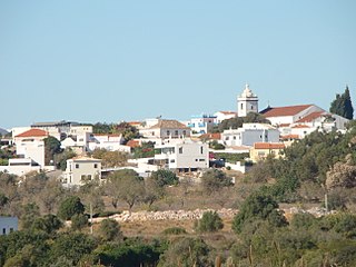
Paderne is a civil parish in the municipality (concelho) of Albufeira, in the Portuguese subregion of the Algarve. The population in 2011 was 3,304, in an area of 52.56 km².

Santa Clara Aqueduct

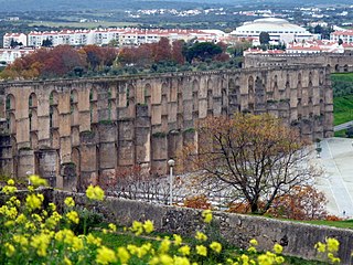
The Aqueduct of Santa Clara is the second largest Portuguese aqueduct system. Built between 1626 and 1714, it includes 999 arches stretching for 4 kilometres (2.5 mi) from the spring of Terroso in the municipality of Póvoa de Varzim to the Convent of Santa Clara in the municipality of Vila do Conde.

Praça do Império City square in Lisboa, Portugal

The Praça do Império is a city square and park situated adjacent to principal monuments and tourist attractions in the civil parish of Belém, municipality and Portuguese capital of Lisbon.

Mexilhoeira Grande Civil parish in Algarve, Portugal

Mexilhoeira Grande is a civil parish in the municipality (concelho) of Portimão in the southern Portuguese region of the Algarve. The population in 2011 was 4,029, in an area of 91.15 km².

The Ponte Romana do Rio Brenhas, sometimes known simply as the Ponta Romana de Moura or Ponte de Moura, is bridge built during the Roman occupation of the Iberian peninsula, that crosses the River Brenhas in the civil parish of Moura e Santo Amador in the municipality of Moura in the Portuguese district of Beja.

Ponte Velha de São Pedro da Torre is a bridge in the civil parish of São Pedro da Torre, municipality of Valença in the Portuguese district of Viana do Castelo.

Roman ruins of Cerro da Vila building in Loulé, Faro District, Portugal

The Roman Ruins of Cerro da Vila are the remnants of a historical villa in the Algarve region of southern Portugal. Its vestiges lie in the vicinity of the resort and marina of Vilamoura, in the civil parish of Quarteira, municipality of Loulé Municipality.

Castle of Valongo building in Évora, Évora District, Portugal

The Castle of Valongo is a well-preserved medieval castle located in the civil parish of Nossa Senhora de Machede, in the municipality of Évora, Portuguese Évora.

Roman ruins of Casais Velhos building in Cascais, Lisbon District, Portugal

The Roman ruins of Casais Velhos are the remains of a Roman town, in the municipality of Cascais, Lisbon District, Portugal that included baths, two cemeteries, remains of a wall and ceramic artifacts.

Roman villa of Alto da Cidreira

The Roman villa of Alto da Cidreira is a Roman villa in the civil parish of Alcabideche, municipality of Cascais, in the Lisbon District of Portugal. Although known since the 1890s, this site has largely been neglected by archaeologists, resulting in destruction of artefacts, including Roman era mosaics, a bath complex and an olive oil cellar.

The Roman villa of Outeiro de Polima ) is a Roman villa in the civil parish of São Domingos de Rana, in the Portuguese municipality of Cascais, dating from the 1st to 6th centuries AD.

The Roman villa of Quinta da Bolacha is a Roman villa in the civil parish of Falagueira-Venda Nova, municipality of Amadora, with an occupation dating from the 3rd and 4th century. It is commonly associated with the nearby Roman aqueduct, as well as the agricultural activities and Chalcedony mining occurring in the district.

The Roman Thermae of Maximinus, are the archaeological ruins of a monumental building and public baths, whose construction was integrated into the urban renewal of the civitas of Bracara Augusta, the Roman provincial capital of Gallaecia. The large public/civic construction consisted of a building, housing the baths, and a theatre, although the archaeological excavations continue.

Torrão Civil parish in Alentejo, Portugal

Torrão is a civil parish and town, in the municipality of Alcácer do Sal, in the Portuguese district of Setúbal, bordering on the districts of Évora and the Beja. It is crossed by the river Xarrama River. The population in 2011 was 2,295, in an area of 372.39 km².

Amoreira Aqueduct 16th-century aqueduct in Elvas, Portugal

The Amoreira Aqueduct is a 16th-century aqueduct that spans the Portuguese municipality of Elvas, bringing water into the fortified seat.

Caniçada Dam dam in Braga, Vieira do Minho, Parada do Bouro

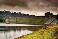
The Caniçada Dam is a concrete arch dam on the Cávado River, the civil parish of Parada do Bouro, in the municipality of Vieira do Minho, in the Portuguese Norte (district of Braga. It is owned by Companhia Portuguesa de Produção de Electricidade.

References

Notes

  1. "Lisboa (Portugal)". Romanaqueducts.info. 2005-03-25. Retrieved 2011-10-21.
  2. 1 2 3 4 5 6 7 8 9 10 11 12 13 14 Noé, Paula (1991), SIPA (ed.), Barragem Romana de Belas (IPA.00006416/PT031111040030) (in Portuguese), Lisbon, Portugal: SIPA – Sistema de Informação para o Património Arquitectónico, retrieved 6 March 2016
  3. 1 2 3 4 Martins, A. (2015), Ruínas da antiga barragem romana donde partia um aqueduto para Olisipo, IGESPAR – Instituto de Gestão do Património Arquitectónico e Arqueológico (Portuguese Institute of Architectural and Archaeological Heritage), retrieved 7 March 2016

Sources