
Shropshire is a landlocked historic county in the West Midlands region of England. It is bordered by Wales to the west and the English counties of Cheshire to the north, Staffordshire to the east, Worcestershire to the southeast, and Herefordshire to the south. A unitary authority of the same name was created in 2009, taking over from the previous county council and five district councils, now governed by Shropshire Council. The borough of Telford and Wrekin has been a separate unitary authority since 1998, but remains part of the ceremonial county.
Halesowen is a market town in the Metropolitan Borough of Dudley, in the county of West Midlands, England.

The Stour(, rhymes with "flour") is a river flowing through the counties of Worcestershire, the West Midlands and Staffordshire in the West Midlands region of England. The Stour is a major tributary of the River Severn, and it is about 25 miles (40 km) in length. It has played a considerable part in the economic history of the region.

Alveley is a village in the Severn Valley in southeast Shropshire, England, about 11 miles (18 km) south-southeast of Bridgnorth. It is in the civil parish of Alveley and Romsley. The 2011 Census recorded the parish population as 2,098. It is served by bus service 297 operated by Arriva Midlands. It is most famously known as being the hometown of Jack Jones, a local magician.
New Frankley in Birmingham is a civil parish in Birmingham, England. As such, it has its own parish council.

Abberley is a village and civil parish in north west Worcestershire, England.

Craven Arms is a market town and civil parish in Shropshire, England, on the A49 road and the Welsh Marches railway line, which link it north and south to the larger towns of Shrewsbury and Ludlow respectively. The Heart of Wales railway line joins the Welsh Marches line at Craven Arms and the town is served by Craven Arms railway station. The town is enclosed to the north by the Shropshire Hills Area of Outstanding Natural Beauty, and to the south is the fortified manor house of Stokesay Castle.
Bayston Hill is a village and civil parish in Shropshire, England. It is 3 miles (5 km) south of the county town Shrewsbury and located on the main A49 road, the Shrewsbury to Hereford road.

The Clent Hills lie 10 miles (16 km) south-west of Birmingham city centre in Clent, Worcestershire, England. The closest towns are Stourbridge and Halesowen, both in the West Midlands conurbation. The Clent Hills range consists of, in order from north-west to south-east: Wychbury Hill, Clent Hill, and Walton Hill. The north Worcestershire range of hills continues eastwards to include Romsley Hill, Waseley Hills and the Lickey Hills.

Romsley is a village and civil parish in the Bromsgrove District of Worcestershire, England, on the east side of the Clent Hills about 4 miles south of Halesowen. In 2001 it had a population of 1,601.

Known as the Hagley Road in Birmingham, the A456 is a main road in England running between Central Birmingham and Woofferton, Shropshire, south of Ludlow. Some sections of the route, for example Edgbaston near Bearwood, are also the route of the Elan Aqueduct which carries Birmingham's water supply from the Elan Valley.

The A442 is a main road which passes through the counties of Worcestershire and Shropshire, in the West Midlands region of England.

Whittington is a small village near Worcester close to Junction 7 of the M5 motorway, bounded by the motorway and the B4084, in the District of Wychavon. The motorway cuts through the village, most of it being on the west side but some houses were left on the east side.

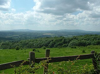
At 316 metres (1,037 ft) above sea level, Walton Hill is the highest point in the range of hills in northern Worcestershire known as the Clent Hills. It is the highest point for 21 miles (34 km) in all directions, and as such commands an excellent panorama. Its neighbours include Clent Hill, Wychbury Hill, Calcot Hill, and Romsley Hill.

Burford is a village and civil parish in Shropshire, England.
Shatterford Hill is an English geographical feature that extends from Bewdley in north Worcestershire to Birdsgreen near Alveley, just over the border in Shropshire. The hill is a long ridge running up the east side of the Severn Valley and peaks at 202 metres near the village of Shatterford on the A442 road between Kidderminster and Bridgnorth.
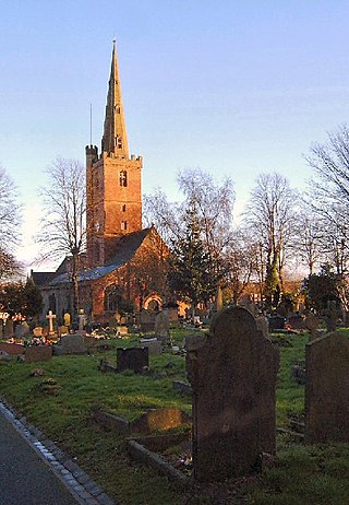
Halesowen was a medieval parish in the West Midlands of England.

The A491 is an A road in Zone 4 of the Great Britain numbering scheme.

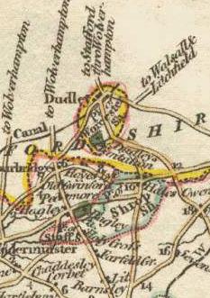
Between the late 11th century and 1844, the English county of Shropshire possessed a large exclave within the present-day Black Country and surrounding area. This territory was gained from neighbouring Worcestershire, and the exclave's border corresponded with the medieval Manor of Hala. Shropshire (Detached) contained the townships of Halesowen, Oldbury, Warley Salop, Ridgacre, Hunnington, Romsley and Langley. The exceptions were Cradley, Lutley and Warley Wigorn, which were exclaves or enclaves still aligned with the original county. Bounded entirely by Staffordshire and Worcestershire, Hala was part of Brimstree hundred, and totally detached from the rest of Shropshire. Bridgnorth, the nearest town within the main body of Shropshire, is 16.8 miles (27.03 km) away from Halesowen, whilst the county town of Shrewsbury is 34.6 miles (55.62 km) away.

